Trail Mountain bike Val-des-Prés - Les Forts de Briançon - Photo
 tracegps
tracegps

User

© OpenStreetMap contributors
Length
Length
35 km
Max alt
Max alt
2442 m
Uphill gradient
Uphill gradient
1402 m
Km-Effort
Km-Effort  
53 km
Min alt
Min alt
1356 m
Downhill gradient
Downhill gradient
1402 m
Boucle
Boucle
Yes
Creation date :
2014-12-10 00:00:00.0
Updated on :
2014-12-10 00:00:00.0

(0 Reviews)

Mountain bike
Mountain bike
3h00
Difficulty : Very difficult

Scan this QR Code to open this trail in the SityTrail application

FREE GPS app for hiking

Logo SityTrail SityTrail

IGN / Geographical institutes

Download SityTrail from the App Store Download SityTrail from Google Play

Logo SityTrail SityTrail World

The world is yours!

Download SityTrail from the App Store Download SityTrail from Google Play Download SityTrail on Huawei AppGallery

About

Trail Mountain bike of 35 km to be discovered at Provence-Alpes-Côte d'Azur, Hautes-Alpes, Val-des-Prés. This trail is proposed by tracegps.

Description

De nouveau sur les traces de la coupe de France marathon de Montgenèvre, météo toujours sympa même si frais en altitude, paysages fantastiques...la suite ICI

Elevation profile

Photos

Positioning

Country:
France
Region :
Provence-Alpes-Côte d'Azur
Department/Province :
Hautes-Alpes
Municipality :
Val-des-Prés
Location:
Unknown
Start:(UTM)
316566 ; 4976627 (32T) N.

Trails nearby

Trail Walking Montgenèvre - Le Chaberton - Photo
Walking
GUIDE
R@ph

Walking

Difficult
(2)
Montgenèvre, Provence-Alpes-Côte d'Azur, Hautes-Alpes, France
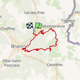
15.4 km | 32 km-effort
6h 15min
Yes
Trail Walking Briançon - Briançon Schappe-3 têtes - Photo
Walking
Orcal37

Walking

Easy
(2)
Briançon, Provence-Alpes-Côte d'Azur, Hautes-Alpes, France
6.5 km | 11 km-effort
2h 5min
Yes
Trail Mountain bike Val-des-Prés - Montgenèvre et col de la Lauze - Photo
Mountain bike
tracegps

Mountain bike

Very difficult
(1)
Val-des-Prés, Provence-Alpes-Côte d'Azur, Hautes-Alpes, France
38 km | 57 km-effort
3h 30min
Yes
Trail Walking Montgenèvre - le mont Chaberton - Photo
Walking
GUIDE
amiral13

Walking

Medium
(1)
Montgenèvre, Provence-Alpes-Côte d'Azur, Hautes-Alpes, France
16.4 km | 33 km-effort
8h 48min
Yes
Trail Walking Montgenèvre - Les crêtes du Chalvet - Photo
Walking
GUIDE
amiral13

Walking

Medium
Montgenèvre, Provence-Alpes-Côte d'Azur, Hautes-Alpes, France
12 km | 23 km-effort
6h 3min
Yes
Trail Walking Val-des-Prés - le Chenaillet et le grand charvia - Photo
Walking
GUIDE
amiral13

Walking

Medium
Val-des-Prés, Provence-Alpes-Côte d'Azur, Hautes-Alpes, France
11.3 km | 19.5 km-effort
4h 17min
No
Trail Walking Montgenèvre - le sommet de Château Jouan et le fort de Janus - Photo
Walking
GUIDE
amiral13

Walking

Difficult
Montgenèvre, Provence-Alpes-Côte d'Azur, Hautes-Alpes, France
13.8 km | 24 km-effort
4h 15min
Yes
Trail Walking Briançon - Circuit: Fort des 3 Têtes et Fort Dauphin - Photo
Walking
GUIDE
lhomme.ph

Walking

Easy
(2)
Briançon, Provence-Alpes-Côte d'Azur, Hautes-Alpes, France
7.4 km | 11.9 km-effort
2h 40min
Yes
Trail Walking Briançon - Briancon: Fort des Trois tètes - Photo
Walking
GUIDE
lhomme.ph

Walking

Very easy
Briançon, Provence-Alpes-Côte d'Azur, Hautes-Alpes, France
5 km | 8.5 km-effort
2h 8min
Yes


Close
My subscriptions