Trail Walking Chevry - CHEVRY:  à travers la campagne - Photo

CHEVRY: à travers la campagne

 chevry
chevry

User

© OpenStreetMap contributors
Length
Length
5.6 km
Max alt
Max alt
558 m
Uphill gradient
Uphill gradient
97 m
Km-Effort
Km-Effort  
6.9 km
Min alt
Min alt
472 m
Downhill gradient
Downhill gradient
100 m
Boucle
Boucle
Yes
Creation date :
2014-12-11 00:00:00.0
Updated on :
2014-12-11 00:00:00.0

(0 Reviews)

Walking
Walking
1h20
Difficulty : Unknown

Scan this QR Code to open this trail in the SityTrail application

FREE GPS app for hiking

Logo SityTrail SityTrail

IGN / Geographical institutes

Download SityTrail from the App Store Download SityTrail from Google Play

Logo SityTrail SityTrail World

The world is yours!

Download SityTrail from the App Store Download SityTrail from Google Play Download SityTrail on Huawei AppGallery

About

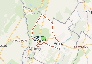
Trail Walking of 5.6 km to be discovered at Auvergne-Rhône-Alpes, Ain, Chevry. This trail is proposed by chevry.

Description

Depuis le parking de l''école Françoise Dolto en face de la poste (1), remontez la rue de la gare. Au carrefour, longez la D984c en direction de Gex (2).

Aux feux tricolores devant la mairie, traversez la route départementale et longez la rue du Château (3). Poursuivez par la route de la Source. Au croisement du chemin de la Vie de l''Auge, prenez tout droit (4), face au Jura ; à la bifurcation suivante, prenez le chemin carrossable  "Chemin de la Fin" (5) qui longe le golf d''Echenevex.

Au croisement suivant, prenez sur la droite (face aux Alpes) (6), le chemin de la vie d''Az. Attention Danger : il faut traverser la route départementale RD 984c  et poursuivre tout droit de l''autre côté (7) (domaine des Bois) en descendant le chemin de la vie d''Az.  

Au stop Béchettes/Vie d''Az, (8) prenez tout droit : face aux Alpes. Au croisement, descendez la route principale par le chemin des Moraines (9). Au rond-point, descendez par la route des Chatelets (St Genis) puis prenez sur la droite le chemin des Molets (10) (face au Jura).

Au carrefour de l''église, prenez la rue St Maurice (sens descente)(11), passage à niveau puis vous arrivez au parking de l''école.

Elevation profile

Points of interest

Point of interest Chevry - 6 - Photo
chevry
CHEVRY 
Point of interest Chevry - 3 - Photo
chevry
CHEVRY 
Point of interest Chevry - 4  - Photo
chevry
CHEVRY 
Point of interest Chevry - 1 - Photo
chevry
CHEVRY 
Point of interest Chevry - rond-point Véraz - Photo
chevry
Point of interest Chevry - 2 - Photo
chevry
CHEVRY 
Point of interest Chevry - 7 - Photo
chevry
CHEVRY 
Point of interest Chevry - 10) Ch des Molets  - Photo
chevry
Point of interest Chevry - 11 - Photo
chevry
CHEVRY 
Point of interest Chevry - Danger  Route - Photo
chevry
CHEVRY 
Point of interest Chevry - 5 - Photo
chevry
CHEVRY 

Positioning

Country:
France
Region :
Auvergne-Rhône-Alpes
Department/Province :
Ain
Municipality :
Chevry
Location:
Unknown
Start:(UTM)
271935 ; 5129535 (32T) N.

Trails nearby

Trail Walking Échenevex - Sources de l''Allondon - Echenevex - Photo
Walking
tracegps

Walking

Medium
Échenevex, Auvergne-Rhône-Alpes, Ain, France
3.5 km | 4.4 km-effort
2h 0min
Yes
Trail Cycle Meyrin - 2012-04-21 11h33m19 - Photo
Cycle
jpvergeres

Cycle

Medium
(1)
Meyrin, Geneva, Unknown, Switzerland
33 km | 39 km-effort
1h 27min
Yes
Trail Cycle Versonnex - Les jardins de l'Europe n°11 - Versonnex - Photo
Cycle
tracegps

Cycle

Medium
Versonnex, Auvergne-Rhône-Alpes, Ain, France
48 km | 55 km-effort
2h 30min
Yes
Trail Running Meyrin - Super Furius - Photo
Running
J-P Ballaman

Running

Easy
Meyrin, Geneva, Unknown, Switzerland
12.6 km | 14.7 km-effort
Unknown
Yes
Trail Walking Thoiry - Sergy  - Photo
Walking
monique surace

Walking

Thoiry, Auvergne-Rhône-Alpes, Ain, France
7.3 km | 8.2 km-effort
1h 49min
Yes
Trail Walking Prévessin-Moëns - 01.01 Pregnin  - Photo
Walking
monique surace

Walking

Prévessin-Moëns, Auvergne-Rhône-Alpes, Ain, France
4.1 km | 4.6 km-effort
1h 3min
No
Trail Running Meyrin - Parcours mesuré - rouge - 8.6km - Photo
Running
Genequand

Running

Medium
Meyrin, Geneva, Unknown, Switzerland
8.6 km | 9.9 km-effort
45min
Yes
Trail Mountain bike Crozet - Crozet,télécabine du fierney - Photo
Mountain bike
Christophe.39

Mountain bike

Difficult
Crozet, Auvergne-Rhône-Alpes, Ain, France
7.3 km | 14 km-effort
1h 30min
No
Trail Nordic walking Meyrin - Walking Foulées automnales 10 km - Photo
Nordic walking
Genequand

Nordic walking

Medium
Meyrin, Geneva, Unknown, Switzerland
10.4 km | 11.8 km-effort
1h 25min
Yes


Close
My subscriptions