Trail Walking Chevry - CHEVRY:  via Segny par les Béchettes - Photo

CHEVRY: via Segny par les Béchettes

 chevry
chevry

User

© OpenStreetMap contributors
Length
Length
6.9 km
Max alt
Max alt
526 m
Uphill gradient
Uphill gradient
77 m
Km-Effort
Km-Effort  
7.9 km
Min alt
Min alt
482 m
Downhill gradient
Downhill gradient
77 m
Boucle
Boucle
Yes
Creation date :
2014-12-11 00:00:00.0
Updated on :
2014-12-11 00:00:00.0

(0 Reviews)

Walking
Walking
1h30
Difficulty : Unknown

Scan this QR Code to open this trail in the SityTrail application

FREE GPS app for hiking

Logo SityTrail SityTrail

IGN / Geographical institutes

Download SityTrail from the App Store Download SityTrail from Google Play

Logo SityTrail SityTrail World

The world is yours!

Download SityTrail from the App Store Download SityTrail from Google Play Download SityTrail on Huawei AppGallery

About

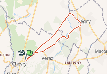
Trail Walking of 6.9 km to be discovered at Auvergne-Rhône-Alpes, Ain, Chevry. This trail is proposed by chevry.

Description

Depuis le parking de l''école Françoise Dolto, prenez la rue principale "rue St Maurice", puis à la sortie de l''agglomération, coupez la route pour prendre tout droit "les Béchettes" (1). Suivez cette route en montant sur la colline. Poursuivez de l''autre côté, direction SEGNY.

En bas de la descente (au niveau du pont du Journans), continuez en forêt. Au 2ème pont, restez sur la route principale puis à la patte d''oie, sur votre droite (2) (à droite de l''abri bus), prenez la rue des Tauques(3) (face aux Alpes), puis la rue du "Journans" (4) ; au virage après la fontaine, restez sur la route principale (5) ; prenez à droite la route des Borrax (6), puis le chemin des Borrax qui longe le "Journans" ; chemin en sous-bois.
Au pont (7), suivez le sentier qui monte en bordure de haie. Au lotissement, suivez le chemin de terre. Au croisement, prenez la route goudronnée (8) puis prenez tout droit. Poursuivez vers le cimetière de Chevry.  
Retour au village en passant devant l''église, jusqu''à l''arrivée.

Elevation profile

Points of interest

Point of interest Chevry - 1 - Photo
chevry
CHEVRY 
Point of interest Chevry - 8 - Photo
chevry
CHEVRY 
Point of interest Chevry - Arrivée - Photo
chevry
CHEVRY 
Point of interest Ségny - 7 - Photo
chevry
SÉGNY 
Point of interest Ségny - 6) Rue des Borrax - Photo
chevry
Point of interest Chevry - arrivée - Photo
chevry
CHEVRY 
Point of interest Chevry - départ - Photo
chevry
CHEVRY 
Point of interest Ségny - 5 - Photo
chevry
SÉGNY 
Point of interest Ségny - 4) Rue du Journans - Photo
chevry
Point of interest Ségny - 2 - Photo
chevry
SÉGNY 
Point of interest Ségny - 3) Rue des Tauques - Photo
chevry

Positioning

Country:
France
Region :
Auvergne-Rhône-Alpes
Department/Province :
Ain
Municipality :
Chevry
Location:
Unknown
Start:(UTM)
271967 ; 5129524 (32T) N.

Trails nearby

Trail Walking Échenevex - Sources de l''Allondon - Echenevex - Photo
Walking
tracegps

Walking

Medium
Échenevex, Auvergne-Rhône-Alpes, Ain, France
3.5 km | 4.4 km-effort
2h 0min
Yes
Trail Cycle Meyrin - 2012-04-21 11h33m19 - Photo
Cycle
jpvergeres

Cycle

Medium
(1)
Meyrin, Geneva, Unknown, Switzerland
33 km | 39 km-effort
1h 27min
Yes
Trail Cycle Versonnex - Les jardins de l'Europe n°11 - Versonnex - Photo
Cycle
tracegps

Cycle

Medium
Versonnex, Auvergne-Rhône-Alpes, Ain, France
48 km | 55 km-effort
2h 30min
Yes
Trail Running Meyrin - Super Furius - Photo
Running
J-P Ballaman

Running

Easy
Meyrin, Geneva, Unknown, Switzerland
12.6 km | 14.7 km-effort
Unknown
Yes
Trail Walking Thoiry - Sergy  - Photo
Walking
monique surace

Walking

Thoiry, Auvergne-Rhône-Alpes, Ain, France
7.3 km | 8.2 km-effort
1h 49min
Yes
Trail Walking Prévessin-Moëns - 01.01 Pregnin  - Photo
Walking
monique surace

Walking

Prévessin-Moëns, Auvergne-Rhône-Alpes, Ain, France
4.1 km | 4.6 km-effort
1h 3min
No
Trail Running Meyrin - Parcours mesuré - rouge - 8.6km - Photo
Running
Genequand

Running

Medium
Meyrin, Geneva, Unknown, Switzerland
8.6 km | 9.9 km-effort
45min
Yes
Trail Mountain bike Crozet - Crozet,télécabine du fierney - Photo
Mountain bike
Christophe.39

Mountain bike

Difficult
Crozet, Auvergne-Rhône-Alpes, Ain, France
7.3 km | 14 km-effort
1h 30min
No
Trail Nordic walking Meyrin - Walking Foulées automnales 10 km - Photo
Nordic walking
Genequand

Nordic walking

Medium
Meyrin, Geneva, Unknown, Switzerland
10.4 km | 11.8 km-effort
1h 25min
Yes


Close
My subscriptions