Tocht Mountainbike Givonne - Espace VTT FFC Pays Sedanais Le Banet - Circuit n° 12 - Photo

Espace VTT FFC Pays Sedanais Le Banet - Circuit n° 12

 tracegps
tracegps

Gebruiker

© OpenStreetMap contributors
Lengte
Lengte
40 km
Max. hoogte
Max. hoogte
440 m
Positief hoogteverschil
796 m
Km-Effort
Km-Effort  
51 km
Min. hoogte
Min. hoogte
224 m
Negatief hoogteverschil
794 m
Boucle
Boucle
Ja
Datum van aanmaak :
2014-12-10 00:00:00.0
Laatste wijziging :
2014-12-10 00:00:00.0

(0 Bericht)

Mountainbike
Mountainbike
4h00
Moeilijkheid : Moeilijk

Scan deze QR-code om de tocht te openen in de SityTrail-applicatie

Gratisgps-wandelapplicatie

Logo SityTrail SityTrail

IGN / Geografische instituten

SityTrail uit de App Store downloaden SityTrail uit Google Play downloaden

Logo SityTrail SityTrail World

De wereld gaat voor u open

SityTrail uit de App Store downloaden SityTrail uit Google Play downloaden SityTrail op Huawei AppGallery downloaden

Over ons

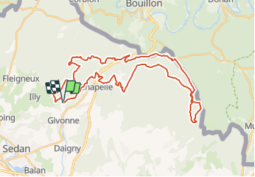
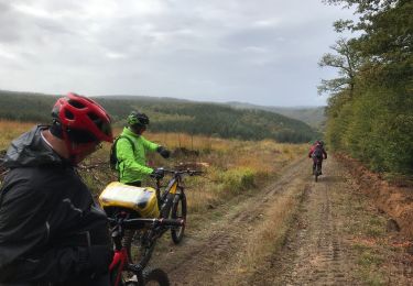
Tocht Mountainbike van 40 km beschikbaar op Grand Est, Ardennes, Givonne. Deze tocht wordt voorgesteld door tracegps.

Beschrijving

Espace VTT FFC Pays Sedanais Le Banet Circuit officiel labellisé par la Fédération Française de Cyclisme. Le Pays sedanais comporte 16 circuits balisés. Grâce à la variété des sites, les sorties sont adaptées aussi bien aux balades en famille qu'aux raids en solitaire. Votre périple pourra vous mener à l'aplomb de la vallée de la Semois entourant la superbe petite bourgade de Bouillon, en Belgique. Attention : Les pistes sont interdites les jours de chasse en batture, la nuit et par temps de neige. Sedan Sprint Club

Hoogteprofiel

Foto's

Plaatsbepaling

Land:
France
Regio :
Grand Est
Departement/Provincie :
Ardennes
Gemeente :
Givonne
Locatie:
Unknown
Vertrek:(Dec)
Vertrek:(UTM)
643337 ; 5510738 (31U) N.

Wandeltochten in de omgeving

Tocht Stappen Illy - Chemin des contrebandiers - Illy - Photo
Stappen
tracegps

Stappen

Gemakkelijk
(2)
Illy, Grand Est, Ardennes, France
7,9 km | 9,9 km-effort
1h 55min
Ja
Tocht Stappen Bazeilles - Du milieu de la forêt à Carignon - Photo
Stappen
jeff2

Stappen

Medium
Bazeilles, Grand Est, Ardennes, France
34 km | 39 km-effort
7h 53min
Neen
Tocht Stappen Illy - départ d'Olly, arrivée au milieu de la forêt domaniale de Sedan, Ardennes - Photo
Stappen
jeff2

Stappen

Medium
Illy, Grand Est, Ardennes, France
28 km | 36 km-effort
8h 51min
Neen
Tocht Mountainbike Sedan - 20191006 Yeyette sur la voie verte à Sedan  - Photo
Mountainbike

Mountainbike

Sedan, Grand Est, Ardennes, France
37 km | 44 km-effort
6h 23min
Ja
Tocht Noords wandelen Saint-Menges - Saint Menges FFSP 4/9/22 - Photo
Noords wandelen
olidri

Noords wandelen

Moeilijk
Saint-Menges, Grand Est, Ardennes, France
21 km | 27 km-effort
3h 17min
Ja
Tocht Huifkarwandeling La Chapelle - SityTrail - FUSION ATTELAGE BOUILLON - Photo
Huifkarwandeling
GUIDE
DUPONT Rita

Huifkarwandeling

Gemakkelijk
La Chapelle, Grand Est, Ardennes, France
23 km | 31 km-effort
Onbekend
Neen
Tocht Te voet Illy - Sentier du Bois Talot - Photo
Te voet
PRO

Te voet

Gemakkelijk
Illy, Grand Est, Ardennes, France
7,9 km | 10 km-effort
2h 15min
Ja
Tocht Mountainbike La Chapelle - 20191004 Yeyette à Givonne jour 1 - Photo
Mountainbike

Mountainbike

Moeilijk
La Chapelle, Grand Est, Ardennes, France
26 km | 33 km-effort
3h 1min
Ja
Tocht Stappen Givonne - FORÊT DE GIVONNES - Photo
Stappen
PascalBanide

Stappen

Gemakkelijk
Givonne, Grand Est, Ardennes, France
11,6 km | 14,6 km-effort
3h 26min
Ja


Sluiten
Mijn abonnementen