Tocht Stappen Sentheim - Sentheim Buchberg - Photo

Sentheim Buchberg

 helmut68
helmut68

Gebruiker

© OpenStreetMap contributors
Lengte
Lengte
14,7 km
Max. hoogte
Max. hoogte
765 m
Positief hoogteverschil
460 m
Km-Effort
Km-Effort  
21 km
Min. hoogte
Min. hoogte
353 m
Negatief hoogteverschil
461 m
Boucle
Boucle
Ja
Datum van aanmaak :
2020-06-01 08:18:12.802
Laatste wijziging :
2020-06-01 21:03:19.807

(0 Bericht)

Stappen
Stappen
3h38
Moeilijkheid : Medium

Scan deze QR-code om de tocht te openen in de SityTrail-applicatie

Gratisgps-wandelapplicatie

Logo SityTrail SityTrail

IGN / Geografische instituten

SityTrail uit de App Store downloaden SityTrail uit Google Play downloaden

Logo SityTrail SityTrail World

De wereld gaat voor u open

SityTrail uit de App Store downloaden SityTrail uit Google Play downloaden SityTrail op Huawei AppGallery downloaden

Over ons

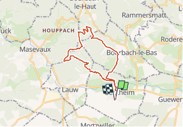
Tocht Stappen van 14,7 km beschikbaar op Grand Est, Haut-Rhin, Sentheim. Deze tocht wordt voorgesteld door helmut68.

Beschrijving

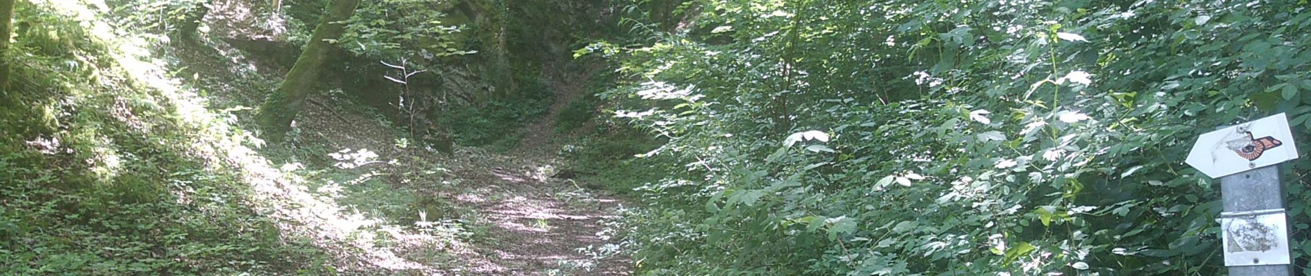
Départ place de jeux de Sentheim (ou place de l'église).Suivre le balisage rectangle " rouge blanc rouge ",une fois le pont de la Doller passé , le suivre jusqu'au Schirm, mais juste un peu avant il faudra monter à gauche pour suivre le balisage "triangle jaune" jusqu'au Gros Chêne.Mais avant vous passerez par le rocher du poilus ( tables et bancs pour...)ou vous aurez une vue splendide sur le début de la vallée de la Doller et le lac de Michelbach.
De là une montée vous amènera jusqu'au Buchberg ou un banc vous attend pour contempler la vallée de Masevaux.
Le retour se fera par le châlet de la Saegenkopf Hutte pour ensuite rejoindre Sentheim en suivant le balisage "Rond Jaune".
Parcours agréable ,souvent à l'ombre, avec de très belles vues...
Alors à vos chaussures !

Hoogteprofiel

Foto's

Plaatsbepaling

Land:
France
Regio :
Grand Est
Departement/Provincie :
Haut-Rhin
Gemeente :
Sentheim
Locatie:
Unknown
Vertrek:(UTM)
353923 ; 5290710 (32T) N.

Wandeltochten in de omgeving

Tocht Stappen Masevaux-Niederbruck - Masevaux - Rossberg par le belvédère du Fuchsfelsen - Photo
Stappen
Bart2015

Stappen

Medium
(1)
Masevaux-Niederbruck, Grand Est, Haut-Rhin, France
19,9 km | 34 km-effort
4h 44min
Ja
Tocht Stappen Sentheim - Sentheim Rossberg - Photo
Stappen
helmut68

Stappen

Medium
(1)
Sentheim, Grand Est, Haut-Rhin, France
27 km | 40 km-effort
6h 11min
Ja
Tocht Stappen Lauw - 2022-07-14 Marche Lauw Refuge CAF Baerenkopf - Photo
Stappen
GUIDE
holtzv

Stappen

Zeer moeilijk
Lauw, Grand Est, Haut-Rhin, France
18,4 km | 31 km-effort
5h 35min
Neen
Tocht Te voet Sentheim - Sentier géologique du Wolfloch - Photo
Te voet
PRO

Te voet

Gemakkelijk
Sentheim, Grand Est, Haut-Rhin, France
3,8 km | 4,8 km-effort
1h 5min
Neen
Tocht Te voet Sentheim - Sentheim - Bergwald - Eichwald - Guevenheim - Sentheim - Photo
Te voet
patrickbeyrath

Te voet

Gemakkelijk
(1)
Sentheim, Grand Est, Haut-Rhin, France
13,4 km | 16,6 km-effort
Onbekend
Ja
Tocht Stappen Sentheim - Knapphutte Saegenkopf Hütte - Photo
Stappen
helmut68

Stappen

Medium
Sentheim, Grand Est, Haut-Rhin, France
13,8 km | 17,2 km-effort
5h 11min
Ja
Tocht Stappen Sentheim - Montori - Photo
Stappen
helmut68

Stappen

Medium
Sentheim, Grand Est, Haut-Rhin, France
17,7 km | 24 km-effort
4h 47min
Ja
Tocht Mountainbike Sentheim - AperoDioller - Photo
Mountainbike
helmut68

Mountainbike

Gemakkelijk
Sentheim, Grand Est, Haut-Rhin, France
24 km | 27 km-effort
1h 23min
Ja
Tocht Stappen Sentheim - Baerenkopf  - Photo
Stappen
helmut68

Stappen

Moeilijk
Sentheim, Grand Est, Haut-Rhin, France
33 km | 49 km-effort
7h 0min
Ja


Sluiten
Mijn abonnementen