Tocht Stappen Sentheim - Bucherg - Photo
 helmut68
helmut68

Gebruiker

© OpenStreetMap contributors
Lengte
Lengte
16,6 km
Max. hoogte
Max. hoogte
765 m
Positief hoogteverschil
494 m
Km-Effort
Km-Effort  
23 km
Min. hoogte
Min. hoogte
353 m
Negatief hoogteverschil
492 m
Boucle
Boucle
Ja
Datum van aanmaak :
2020-10-18 09:04:42.743
Laatste wijziging :
2022-07-16 20:51:44.641

(0 Bericht)

Stappen
Stappen
4h00
Moeilijkheid : Medium

Scan deze QR-code om de tocht te openen in de SityTrail-applicatie

Gratisgps-wandelapplicatie

Logo SityTrail SityTrail

IGN / Geografische instituten

SityTrail uit de App Store downloaden SityTrail uit Google Play downloaden

Logo SityTrail SityTrail World

De wereld gaat voor u open

SityTrail uit de App Store downloaden SityTrail uit Google Play downloaden SityTrail op Huawei AppGallery downloaden

Over ons

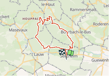
Tocht Stappen van 16,6 km beschikbaar op Grand Est, Haut-Rhin, Sentheim. Deze tocht wordt voorgesteld door helmut68.

Beschrijving

Départ et arrivée place de l'église de Sentheim
Traversez le vieux village , ensuite la Doller par le pont des vignes et sur votre droite  suivez le chemin balisé " anneau jaune" jusqu'au parcours sportif de Bourbach le Bas .
Là ,prenez la direction col du Schirm balisé " rectangle rouge blanc rouge". Un peu avant ce dernier , un chemin ,puis sentier balisé " triangle jaune" vous amènera au "Rocher du Poilu " ( tables de pique-nique ) puis au sommet du Buchberg .  Deux points de vue sur la basse vallée de la Doller , Masevaux, le lac de Michelbach ...Pour le retour suivez toujours le balisage " triangle jaune " jusqu'au " Gros Chêne " Là ,prenez le balisage "disque jaune " jusqu'à l'entrée de Lauw et de suite la route ( à votre gauche ) balisée " triangle bleu" puis le sentier de découverte qui vous amènera à nouveau à Sentheim.
Alors à vos chaussures !

Hoogteprofiel

Foto's

Plaatsbepaling

Land:
France
Regio :
Grand Est
Departement/Provincie :
Haut-Rhin
Gemeente :
Sentheim
Locatie:
Unknown
Vertrek:(UTM)
353916 ; 5290610 (32T) N.

Wandeltochten in de omgeving

Tocht Stappen Masevaux-Niederbruck - Masevaux - Rossberg par le belvédère du Fuchsfelsen - Photo
Stappen
Bart2015

Stappen

Medium
(1)
Masevaux-Niederbruck, Grand Est, Haut-Rhin, France
19,9 km | 34 km-effort
4h 44min
Ja
Tocht Stappen Sentheim - Sentheim Rossberg - Photo
Stappen
helmut68

Stappen

Medium
(1)
Sentheim, Grand Est, Haut-Rhin, France
27 km | 40 km-effort
6h 11min
Ja
Tocht Stappen Lauw - 2022-07-14 Marche Lauw Refuge CAF Baerenkopf - Photo
Stappen
GUIDE
holtzv

Stappen

Zeer moeilijk
Lauw, Grand Est, Haut-Rhin, France
18,4 km | 31 km-effort
5h 35min
Neen
Tocht Te voet Sentheim - Sentier géologique du Wolfloch - Photo
Te voet
PRO

Te voet

Gemakkelijk
Sentheim, Grand Est, Haut-Rhin, France
3,8 km | 4,8 km-effort
1h 5min
Neen
Tocht Te voet Sentheim - Sentheim - Bergwald - Eichwald - Guevenheim - Sentheim - Photo
Te voet
patrickbeyrath

Te voet

Gemakkelijk
(1)
Sentheim, Grand Est, Haut-Rhin, France
13,4 km | 16,6 km-effort
Onbekend
Ja
Tocht Stappen Sentheim - Knapphutte Saegenkopf Hütte - Photo
Stappen
helmut68

Stappen

Medium
Sentheim, Grand Est, Haut-Rhin, France
13,8 km | 17,2 km-effort
5h 11min
Ja
Tocht Stappen Sentheim - Montori - Photo
Stappen
helmut68

Stappen

Medium
Sentheim, Grand Est, Haut-Rhin, France
17,7 km | 24 km-effort
4h 47min
Ja
Tocht Mountainbike Sentheim - AperoDioller - Photo
Mountainbike
helmut68

Mountainbike

Gemakkelijk
Sentheim, Grand Est, Haut-Rhin, France
24 km | 27 km-effort
1h 23min
Ja
Tocht Stappen Sentheim - Baerenkopf  - Photo
Stappen
helmut68

Stappen

Moeilijk
Sentheim, Grand Est, Haut-Rhin, France
33 km | 49 km-effort
7h 0min
Ja


Sluiten
Mijn abonnementen