boucle autour du Cucurucull
PVERTICAL
Gebruiker
Lengte
12,8 km
Max. hoogte
2366 m
Positief hoogteverschil
1062 m
Km-Effort
27 km
Min. hoogte
1316 m
Negatief hoogteverschil
1062 m
Boucle
Ja
Datum van aanmaak :
2018-04-17 19:46:10.548
Laatste wijziging :
2018-04-17 19:46:10.548
7h21
Moeilijkheid : Moeilijk
Gratisgps-wandelapplicatie
Over ons
Tocht Sneeuwschoenen van 12,8 km beschikbaar op Occitanië, Pyrénées-Orientales, Fontpédrouse. Deze tocht wordt voorgesteld door PVERTICAL.
Beschrijving
depuis Prats Balaguer et ascension du col Mitja - bien respecter le sens de la boucle (moins difficile) - possiblité de ne pas faire le col de Mitja
Plaatsbepaling
Land:
France
Regio :
Occitanië
Departement/Provincie :
Pyrénées-Orientales
Gemeente :
Fontpédrouse
Locatie:
Unknown
Vertrek:(Dec)
Vertrek:(UTM)
431956 ; 4705493 (31T) N.
Opmerkingen
Wandeltochten in de omgeving
boucle des gorges de Caranca
Stappen
Medium
(2)
Thuès-Entre-Valls,
Occitanië,
Pyrénées-Orientales,
France
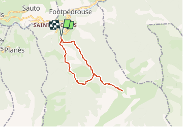
7,2 km | 15,3 km-effort
3h 1min
Ja
Gorges de la garanca
Stappen
Heel gemakkelijk
(1)
Thuès-Entre-Valls,
Occitanië,
Pyrénées-Orientales,
France
6,7 km | 13,1 km-effort
3h 39min
Neen
Tour du Cucurucull
Stappen
Medium
(1)
Fontpédrouse,
Occitanië,
Pyrénées-Orientales,
France
9,3 km | 18,5 km-effort
3h 24min
Ja
étang de Planès
Stappen
Medium
(2)
Planès,
Occitanië,
Pyrénées-Orientales,
France
10,8 km | 19,6 km-effort
3h 54min
Neen
fontpérouse sentier des canaux et sources chaudes naturelles_T
Stappen
Medium
(1)
Fontpédrouse,
Occitanië,
Pyrénées-Orientales,
France
13,7 km | 25 km-effort
5h 9min
Ja
bains de St Thomas
Stappen
Medium
(1)
Saint-Pierre-dels-Forcats,
Occitanië,
Pyrénées-Orientales,
France
8,6 km | 12,2 km-effort
2h 42min
Neen
llagonne - Calvet
Stappen
Medium
(2)
La Llagonne,
Occitanië,
Pyrénées-Orientales,
France
11,2 km | 14,2 km-effort
3h 0min
Neen
Gorges de Carança
Stappen
Medium
(2)
Thuès-Entre-Valls,
Occitanië,
Pyrénées-Orientales,
France
13,6 km | 30 km-effort
3h 43min
Ja
2022 TRANSPYRÉNÉENNE : refuge du Ras de la Carança
Stappen
Moeilijk
Fontpédrouse,
Occitanië,
Pyrénées-Orientales,
France
17,2 km | 31 km-effort
4h 36min
Neen