Tocht Mountainbike Petitefontaine - randonnee damien b0f9f1be9aec2b53eed3c73a4403da5a - Photo

randonnee damien b0f9f1be9aec2b53eed3c73a4403da5a

 jibus90
jibus90

Gebruiker

© OpenStreetMap contributors
Lengte
Lengte
19,5 km
Max. hoogte
Max. hoogte
423 m
Positief hoogteverschil
231 m
Km-Effort
Km-Effort  
23 km
Min. hoogte
Min. hoogte
297 m
Negatief hoogteverschil
314 m
Boucle
Boucle
Neen
Datum van aanmaak :
2018-09-30 18:57:21.443
Laatste wijziging :
2018-09-30 18:57:21.448

(0 Bericht)

Mountainbike
Mountainbike
--
Moeilijkheid : Medium

Scan deze QR-code om de tocht te openen in de SityTrail-applicatie

Gratisgps-wandelapplicatie

Logo SityTrail SityTrail

IGN / Geografische instituten

SityTrail uit de App Store downloaden SityTrail uit Google Play downloaden

Logo SityTrail SityTrail World

De wereld gaat voor u open

SityTrail uit de App Store downloaden SityTrail uit Google Play downloaden SityTrail op Huawei AppGallery downloaden

Over ons

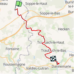
Tocht Mountainbike van 19,5 km beschikbaar op Bourgondië-Franche-Comté, Territoire-de-Belfort, Petitefontaine. Deze tocht wordt voorgesteld door jibus90.

Hoogteprofiel

Plaatsbepaling

Land:
France
Regio :
Bourgondië-Franche-Comté
Departement/Provincie :
Territoire-de-Belfort
Gemeente :
Petitefontaine
Locatie:
Unknown
Vertrek:(Dec)
Vertrek:(UTM)
350453 ; 5287362 (32T) N.

Wandeltochten in de omgeving

Tocht Stappen Sentheim - Sentheim Rossberg - Photo
Stappen
helmut68

Stappen

Medium
(1)
Sentheim, Grand Est, Haut-Rhin, France
27 km | 40 km-effort
6h 11min
Ja
Tocht Stappen Lauw - 2022-07-14 Marche Lauw Refuge CAF Baerenkopf - Photo
Stappen
GUIDE
holtzv

Stappen

Zeer moeilijk
Lauw, Grand Est, Haut-Rhin, France
18,4 km | 31 km-effort
5h 35min
Neen
Tocht Te voet Sentheim - Sentier géologique du Wolfloch - Photo
Te voet
PRO

Te voet

Gemakkelijk
Sentheim, Grand Est, Haut-Rhin, France
3,8 km | 4,8 km-effort
1h 5min
Neen
Tocht Te voet Sentheim - Sentheim - Bergwald - Eichwald - Guevenheim - Sentheim - Photo
Te voet
patrickbeyrath

Te voet

Gemakkelijk
(1)
Sentheim, Grand Est, Haut-Rhin, France
13,4 km | 16,6 km-effort
Onbekend
Ja
Tocht Stappen Sentheim - Knapphutte Saegenkopf Hütte - Photo
Stappen
helmut68

Stappen

Medium
Sentheim, Grand Est, Haut-Rhin, France
13,8 km | 17,2 km-effort
5h 11min
Ja
Tocht Stappen Sentheim - Montori - Photo
Stappen
helmut68

Stappen

Medium
Sentheim, Grand Est, Haut-Rhin, France
17,7 km | 24 km-effort
4h 47min
Ja
Tocht Mountainbike Sentheim - AperoDioller - Photo
Mountainbike
helmut68

Mountainbike

Gemakkelijk
Sentheim, Grand Est, Haut-Rhin, France
24 km | 27 km-effort
1h 23min
Ja
Tocht Stappen Sentheim - Baerenkopf  - Photo
Stappen
helmut68

Stappen

Moeilijk
Sentheim, Grand Est, Haut-Rhin, France
33 km | 49 km-effort
7h 0min
Ja
Tocht Stappen Sentheim - Lac Seigneurie Soultzbach - Photo
Stappen
helmut68

Stappen

Gemakkelijk
Sentheim, Grand Est, Haut-Rhin, France
10,9 km | 12,7 km-effort
3h 26min
Ja


Sluiten
Mijn abonnementen