Trail Walking Courchevel - Raid de Tarentaise en Maurienne - Photo

Raid de Tarentaise en Maurienne

 tracegps
tracegps

User

© OpenStreetMap contributors
Length
Length
78 km
Max alt
Max alt
2942 m
Uphill gradient
Uphill gradient
6985 m
Km-Effort
Km-Effort  
171 km
Min alt
Min alt
1408 m
Downhill gradient
Downhill gradient
6986 m
Boucle
Boucle
Yes
Creation date :
2014-12-10 00:00:00.0
Updated on :
2014-12-10 00:00:00.0

(0 Reviews)

Walking
Walking
60h00
Difficulty : Very difficult

Scan this QR Code to open this trail in the SityTrail application

FREE GPS app for hiking

Logo SityTrail SityTrail

IGN / Geographical institutes

Download SityTrail from the App Store Download SityTrail from Google Play

Logo SityTrail SityTrail World

The world is yours!

Download SityTrail from the App Store Download SityTrail from Google Play Download SityTrail on Huawei AppGallery

About

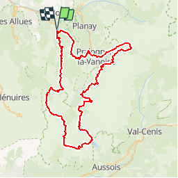
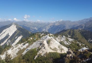
Trail Walking of 78 km to be discovered at Auvergne-Rhône-Alpes, Savoy, Courchevel. This trail is proposed by tracegps.

Description

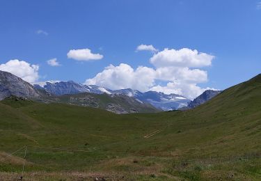
Raid de 4 à 6 jours, en plein coeur du Parc National de la Vanoise. Etapes moyennes, échappées toujours possibles dans la journée en cas de gros temps. Tous les détails de ce raid sont sur Montagne-Cool

Elevation profile

Photos

Positioning

Country:
France
Region :
Auvergne-Rhône-Alpes
Department/Province :
Savoy
Municipality :
Courchevel
Location:
Saint-Bon-Tarentaise
Start:(UTM)
315701 ; 5032245 (32T) N.

Trails nearby

Trail Walking Pralognan-la-Vanoise - Pralognan - la crête du mont Charvet - Photo
Walking
countryjack

Walking

Medium
(1)
Pralognan-la-Vanoise, Auvergne-Rhône-Alpes, Savoy, France
11.4 km | 24 km-effort
5h 1min
No
Trail Walking Courchevel - lac des creux au départ de l'altiport  - Photo
Walking
Klhn

Walking

Easy
(1)
Courchevel, Auvergne-Rhône-Alpes, Savoy, France
6.8 km | 11.1 km-effort
2h 40min
Yes
Trail Mountain bike Bozel - activity_9181659290 (1) - Photo
Mountain bike
GUIDE
pascalou73

Mountain bike

Easy
Bozel, Auvergne-Rhône-Alpes, Savoy, France
9.4 km | 13.8 km-effort
57min
Yes
Trail Walking Courchevel - Petit Mont Blanc par Courchevel - Photo
Walking
Brusa

Walking

Easy
(1)
Courchevel, Auvergne-Rhône-Alpes, Savoy, France
19.8 km | 34 km-effort
6h 59min
Yes
Trail Walking Bozel - mont de la guerre - Photo
Walking
whisper73

Walking

Easy
(1)
Bozel, Auvergne-Rhône-Alpes, Savoy, France
7.6 km | 21 km-effort
Unknown
No
Trail Walking Courchevel - Brêche de la Portetta - Photo
Walking
tracegps

Walking

Very difficult
(1)
Courchevel, Auvergne-Rhône-Alpes, Savoy, France
12.7 km | 27 km-effort
5h 0min
Yes
Trail Walking Courchevel - Courchevel-Moriond,  Lac de  la Rosière, col de la Chal, crête du Mont Charvet, col de Grosse Pierre, Cascades des Poux - Photo
Walking
ranchoup

Walking

Difficult
Courchevel, Auvergne-Rhône-Alpes, Savoy, France
12.8 km | 25 km-effort
5h 36min
Yes
Trail Walking Courchevel - lacs Merlet depuis vallon des Avals - Photo
Walking
bymarc26

Walking

Medium
Courchevel, Auvergne-Rhône-Alpes, Savoy, France
18.4 km | 31 km-effort
5h 5min
Yes
Trail Walking Bozel - Hauteville Montfort - Photo
Walking
franquen

Walking

Difficult
Bozel, Auvergne-Rhône-Alpes, Savoy, France
37 km | 59 km-effort
1h 30min
Yes


Close
My subscriptions