Trail Mountain bike Saint-Pierre-dels-Forcats - Espace VTT - FFC Capcir - Haut Confluent - Circuit n°14 - Pla du Cambra d'Ase - Photo

Espace VTT - FFC Capcir - Haut Confluent - Circuit n°14 - Pla du Cambra d'Ase

 tracegps
tracegps

User

© OpenStreetMap contributors
Length
Length
7.9 km
Max alt
Max alt
1945 m
Uphill gradient
Uphill gradient
302 m
Km-Effort
Km-Effort  
11.9 km
Min alt
Min alt
1638 m
Downhill gradient
Downhill gradient
302 m
Boucle
Boucle
Yes
Creation date :
2014-12-10 00:00:00.0
Updated on :
2014-12-10 00:00:00.0

(0 Reviews)

Mountain bike
Mountain bike
2h00
Difficulty : Difficult

Scan this QR Code to open this trail in the SityTrail application

FREE GPS app for hiking

Logo SityTrail SityTrail

IGN / Geographical institutes

Download SityTrail from the App Store Download SityTrail from Google Play

Logo SityTrail SityTrail World

The world is yours!

Download SityTrail from the App Store Download SityTrail from Google Play Download SityTrail on Huawei AppGallery

About

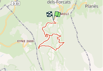
Trail Mountain bike of 7.9 km to be discovered at Occitania, Pyrénées-Orientales, Saint-Pierre-dels-Forcats. This trail is proposed by tracegps.

Description

Espace VTT - FFC Capcir – Haut Confluent Circuit officiel labellisé par la Fédération Française de Cyclisme. Ce parcours sportif avec un fort dénivelé vous permettra de découvrir de plus près le magnifique cirque du Cambra d’Ase (Cambre d’Aze), visible de la Cerdagne au Capcir.

Elevation profile

Photos

Positioning

Country:
France
Region :
Occitania
Department/Province :
Pyrénées-Orientales
Municipality :
Saint-Pierre-dels-Forcats
Location:
Unknown
Start:(UTM)
427403 ; 4704067 (31T) N.

Trails nearby

Trail Walking Eyne - Eyne,col de Nuria,pic d'Eyne,Torre d'Eyne,Eyne. - Photo
Walking
Machaon6

Walking

Very difficult
(1)
Eyne, Occitania, Pyrénées-Orientales, France
24 km | 43 km-effort
8h 44min
Yes
Trail Walking Fontpédrouse - Tour du Cucurucull - Photo
Walking
Pek56

Walking

Medium
(1)
Fontpédrouse, Occitania, Pyrénées-Orientales, France
9.3 km | 18.5 km-effort
3h 24min
Yes
Trail Walking Planès - étang de Planès - Photo
Walking
fhascoet

Walking

Medium
(2)
Planès, Occitania, Pyrénées-Orientales, France
10.8 km | 19.6 km-effort
3h 54min
No
Trail Walking Fontpédrouse - fontpérouse sentier des canaux et sources chaudes naturelles_T - Photo
Walking
force

Walking

Medium
(1)
Fontpédrouse, Occitania, Pyrénées-Orientales, France
13.7 km | 25 km-effort
5h 9min
Yes
Trail Walking Eyne - Le Cambre d'Ase - Photo
Walking
tracegps

Walking

Difficult
(1)
Eyne, Occitania, Pyrénées-Orientales, France
8.9 km | 22 km-effort
4h 0min
Yes
Trail Walking Eyne - Vallée d'Eyne - Photo
Walking
GUIDE
nadinebondoux

Walking

Medium
Eyne, Occitania, Pyrénées-Orientales, France
10.7 km | 17.6 km-effort
4h 40min
Yes
Trail Walking Bolquère - bolqueres - Photo
Walking
foxtay

Walking

Very easy
(1)
Bolquère, Occitania, Pyrénées-Orientales, France
3.8 km | 4.6 km-effort
1h 1min
Yes
Trail Walking Saint-Pierre-dels-Forcats - bains  de St Thomas  - Photo
Walking
Ptitjack30

Walking

Medium
(1)
Saint-Pierre-dels-Forcats, Occitania, Pyrénées-Orientales, France
8.6 km | 12.2 km-effort
2h 42min
No
Trail Walking La Llagonne - llagonne - Calvet - Photo
Walking
merencianoep

Walking

Medium
(2)
La Llagonne, Occitania, Pyrénées-Orientales, France
11.2 km | 14.2 km-effort
3h 0min
No


Close
My subscriptions