Trail Mountain bike Lacrouzette - Ronde des rochers 2008 - Photo

Ronde des rochers 2008

 tracegps
tracegps

User

© OpenStreetMap contributors
Length
Length
30 km
Max alt
Max alt
700 m
Uphill gradient
Uphill gradient
711 m
Km-Effort
Km-Effort  
39 km
Min alt
Min alt
484 m
Downhill gradient
Downhill gradient
710 m
Boucle
Boucle
Yes
Creation date :
2014-12-10 00:00:00.0
Updated on :
2014-12-10 00:00:00.0

(1 Reviews)

Mountain bike
Mountain bike
2h15
Difficulty : Medium

Scan this QR Code to open this trail in the SityTrail application

FREE GPS app for hiking

Logo SityTrail SityTrail

IGN / Geographical institutes

Download SityTrail from the App Store Download SityTrail from Google Play

Logo SityTrail SityTrail World

The world is yours!

Download SityTrail from the App Store Download SityTrail from Google Play Download SityTrail on Huawei AppGallery

About

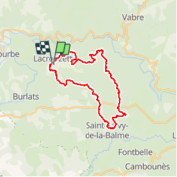
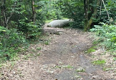
Trail Mountain bike of 30 km to be discovered at Occitania, Tarn, Lacrouzette. This trail is proposed by tracegps.

Description

Ronde des Rochers édition 2008. Organisée par les VTT Club et Vélo Club Crouzétols, la traditionnelle ronde des rochers du 11 novembre a fêté ses dix ans d'existence. Elle s'élance du Foyer rural de Lacrouzette vers les sentiers et chemins forestiers du Sidobre. Deux boucles inédites d'une vingtaine et d'une trentaine de kilomètres, tracées et imaginées à travers les somptueux et éclatants paysages automnaux des bois de cet exceptionnel massif granitique du Parc régional du Haut Languedoc, ont été proposées aux nombreux vététistes.

Elevation profile

Positioning

Country:
France
Region :
Occitania
Department/Province :
Tarn
Municipality :
Lacrouzette
Location:
Unknown
Start:(UTM)
447317 ; 4834297 (31T) N.

Comments

Please log in to post a review or rate the element


tres agréable et très beau


Trails nearby

Trail Walking Lacrouzette - les rochers de sidobre  - Photo
Walking
leroj73

Walking

Very easy
(1)
Lacrouzette, Occitania, Tarn, France
11.9 km | 15.5 km-effort
3h 31min
Yes
Trail Walking Lacrouzette - OR-7523970--Lacrouzette:2017-06-10 Sidobre rocs de crémaussel et Lac du Merle - Photo
Walking
cappelle

Walking

Very difficult
(1)
Lacrouzette, Occitania, Tarn, France
15.6 km | 21 km-effort
4h 39min
Yes
Trail On foot Lacrouzette - les rochers du sidobre - Photo
On foot
leroj73

On foot

Very easy
(1)
Lacrouzette, Occitania, Tarn, France
11.2 km | 15.2 km-effort
Unknown
Yes
Trail Mountain bike Lacrouzette - Lacrouzette VTT 2016 - Photo
Mountain bike
J-Mi

Mountain bike

Easy
(3)
Lacrouzette, Occitania, Tarn, France
32 km | 41 km-effort
2h 36min
Yes
Trail On foot Burlats - Chemin des Fontaines - Photo
On foot
PRO

On foot

Easy
Burlats, Occitania, Tarn, France
7.3 km | 8.5 km-effort
1h 55min
No
Trail Walking Burlats - Burlats cascade de la truite - Photo
Walking
poisson1103

Walking

Medium
Burlats, Occitania, Tarn, France
19.3 km | 30 km-effort
5h 22min
No
Trail Walking Burlats - billets l'Agout 18kms 577m 4h30 - Photo
Walking
guiller

Walking

Easy
Burlats, Occitania, Tarn, France
18.2 km | 25 km-effort
4h 44min
Yes
Trail Walking Lacrouzette - Sidobre - Photo
Walking
pantin

Walking

Medium
Lacrouzette, Occitania, Tarn, France
14.7 km | 19.1 km-effort
4h 21min
Yes
Trail Walking Burlats - Sidobre Castres  - Photo
Walking
GUIDE
Ada11

Walking

Easy
Burlats, Occitania, Tarn, France
18.8 km | 26 km-effort
4h 28min
Yes


Close
My subscriptions