Trail Walking Wegscheid - Forêt des volcans à Wegscheid - Photo

Forêt des volcans à Wegscheid

 tracegps
tracegps

User

© OpenStreetMap contributors
Length
Length
11.4 km
Max alt
Max alt
1036 m
Uphill gradient
Uphill gradient
633 m
Km-Effort
Km-Effort  
19.9 km
Min alt
Min alt
525 m
Downhill gradient
Downhill gradient
631 m
Boucle
Boucle
Yes
Creation date :
2014-12-10 00:00:00.0
Updated on :
2014-12-10 00:00:00.0

(0 Reviews)

Walking
Walking
4h00
Difficulty : Medium

Scan this QR Code to open this trail in the SityTrail application

FREE GPS app for hiking

Logo SityTrail SityTrail

IGN / Geographical institutes

Download SityTrail from the App Store Download SityTrail from Google Play

Logo SityTrail SityTrail World

The world is yours!

Download SityTrail from the App Store Download SityTrail from Google Play Download SityTrail on Huawei AppGallery

About

Trail Walking of 11.4 km to be discovered at Grand Est, Haut-Rhin, Wegscheid. This trail is proposed by tracegps.

Description

Beau circuit, principalement en forêt, parsemé de curiosités sur le plan géologique et agrémenté de superbes chalets-refuges. Accès en voiture : D466 en provenance de Masevaux, traverser le village de Wegscheid. A la sortie du village, prendre la route à droite sur environ 2km. Se garer sur un parking en contrebas d'un réservoir.

Elevation profile

Photos

Points of interest

Point of interest Wegscheid - 1020m - Photo
tracegps
WEGSCHEID 
Point of interest Wegscheid - Bifurcation - Photo
tracegps
WEGSCHEID 
Point of interest Masevaux-Niederbruck - Chalet Sattelboden (913m) - Photo
tracegps
MASEVAUX-NIEDERBRUCK 
Point of interest Rimbach-près-Masevaux - Chalet Stahlberg (839m) - Photo
tracegps
RIMBACH-PRÈS-MASEVAUX 
Point of interest Wegscheid - Falaise Fuchsfelsen (980) - Photo
tracegps
Point of interest Wegscheid - Parking (530m) - Photo
tracegps
WEGSCHEID 

Positioning

Country:
France
Region :
Grand Est
Department/Province :
Haut-Rhin
Municipality :
Wegscheid
Location:
Unknown
Start:(UTM)
348073 ; 5297981 (32T) N.

Trails nearby

Trail Walking Masevaux-Niederbruck - Masevaux - Rossberg par le belvédère du Fuchsfelsen - Photo
Walking
Bart2015

Walking

Medium
(1)
Masevaux-Niederbruck, Grand Est, Haut-Rhin, France
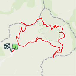
19.9 km | 34 km-effort
4h 44min
Yes
Trail Walking Rimbach-près-Masevaux - Haute Bers - Photo
Walking
helmut68

Walking

Medium
(1)
Rimbach-près-Masevaux, Grand Est, Haut-Rhin, France
12 km | 20 km-effort
3h 25min
Yes
Trail Walking Sewen - Boucle entre les lacs de Sewen et d'Alfeld - Photo
Walking
tracegps

Walking

Medium
(1)
Sewen, Grand Est, Haut-Rhin, France
8.1 km | 12.3 km-effort
2h 30min
Yes
Trail Walking Storckensohn - lac des perches marchettes - Photo
Walking
lacote

Walking

Medium
(1)
Storckensohn, Grand Est, Haut-Rhin, France
11.9 km | 20 km-effort
4h 8min
Yes
Trail Walking Storckensohn - 2022-07-16 Marche Auberge Gazon Vert Chapelle des Ves - Photo
Walking
GUIDE
holtzv

Walking

Very difficult
Storckensohn, Grand Est, Haut-Rhin, France
21 km | 37 km-effort
6h 11min
No
Trail Walking Kirchberg - 2022-07-15 Marche Refuge Baerenkopf Auberge Gazon Vert - Photo
Walking
GUIDE
holtzv

Walking

Very difficult
Kirchberg, Grand Est, Haut-Rhin, France
23 km | 38 km-effort
8h 21min
No
Trail Walking Masevaux-Niederbruck - Rando CLAS du 25/04/2024 - Photo
Walking
boubou68

Walking

Very difficult
Masevaux-Niederbruck, Grand Est, Haut-Rhin, France
17 km | 28 km-effort
4h 24min
Yes
Trail Walking Kirchberg - Rando du 11/04/2024  ..Marcheurs - Photo
Walking
boubou68

Walking

Very difficult
Kirchberg, Grand Est, Haut-Rhin, France
23 km | 37 km-effort
5h 37min
Yes
Trail Walking Sewen - Sewen - abris de Dolleren et du Sommerseite - Lachtelweiher - Col du Lochberg - Wissgrut - Photo
Walking
Bart2015

Walking

Very difficult
Sewen, Grand Est, Haut-Rhin, France
24 km | 39 km-effort
8h 58min
Yes


Close
My subscriptions