Trail Walking Buhl - Le Hohrupf depuis Buhl - Photo

Le Hohrupf depuis Buhl

 tracegps
tracegps

User

© OpenStreetMap contributors
Length
Length
9.5 km
Max alt
Max alt
795 m
Uphill gradient
Uphill gradient
447 m
Km-Effort
Km-Effort  
15.5 km
Min alt
Min alt
361 m
Downhill gradient
Downhill gradient
450 m
Boucle
Boucle
Yes
Creation date :
2014-12-10 00:00:00.0
Updated on :
2014-12-10 00:00:00.0

(0 Reviews)

Walking
Walking
3h00
Difficulty : Medium

Scan this QR Code to open this trail in the SityTrail application

FREE GPS app for hiking

Logo SityTrail SityTrail

IGN / Geographical institutes

Download SityTrail from the App Store Download SityTrail from Google Play

Logo SityTrail SityTrail World

The world is yours!

Download SityTrail from the App Store Download SityTrail from Google Play Download SityTrail on Huawei AppGallery

About

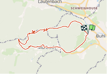
Trail Walking of 9.5 km to be discovered at Grand Est, Haut-Rhin, Buhl. This trail is proposed by tracegps.

Description

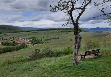
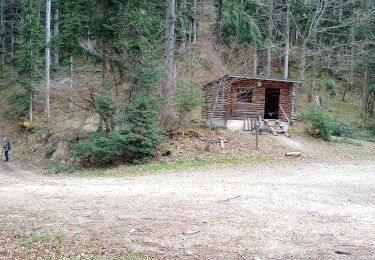
Le château du Hohrupf a été édifié au 13e siècle pour protéger l'abbaye de Murbach. Perché sur un belvédère à une altitude de 813m, il ne subsiste plus que quelques ruines, mais le panorama 360° vaut le détour. Le circuit part de Buhl et rejoint le Hohrupf par une pente régulière en 1h15. Au retour nous avons fait un détour par le col du Wolfsgrübe et par l'abbaye de Mürbach qui vaut bien une petite visite.

Elevation profile

Photos

Positioning

Country:
France
Region :
Grand Est
Department/Province :
Haut-Rhin
Municipality :
Buhl
Location:
Unknown
Start:(UTM)
364133 ; 5309949 (32T) N.

Trails nearby

Trail On foot Goldbach-Altenbach - Firstacker - Willer sur Thur - Photo
On foot
PRO

On foot

Easy
Goldbach-Altenbach, Grand Est, Haut-Rhin, France
7.4 km | 9.6 km-effort
2h 11min
No
Trail Walking Soultz-Haut-Rhin - Rando Marcheurs..04/04_2025 - Photo
Walking
boubou68

Walking

Very difficult
Soultz-Haut-Rhin, Grand Est, Haut-Rhin, France
21 km | 35 km-effort
4h 42min
Yes
Trail Walking Murbach - La
Walking
boubou68

Walking

Very difficult
Murbach, Grand Est, Haut-Rhin, France
14.7 km | 28 km-effort
4h 3min
Yes
Trail Walking Murbach - Murbach - Photo
Walking
oscar1

Walking

Difficult
Murbach, Grand Est, Haut-Rhin, France
15.4 km | 25 km-effort
4h 25min
Yes
Trail Walking Soultzmatt - Rando du 30/03/2034 - Photo
Walking
boubou68

Walking

Difficult
Soultzmatt, Grand Est, Haut-Rhin, France
19.5 km | 29 km-effort
4h 32min
Yes
Trail Walking Goldbach-Altenbach - Firstacker - Grand Ballon (11/08/2022) - Photo
Walking
Richard68500

Walking

Medium
Goldbach-Altenbach, Grand Est, Haut-Rhin, France
14.2 km | 22 km-effort
4h 22min
Yes
Trail Walking Linthal - Linthal - Petit Ballon - Klintzkopf - Photo
Walking
Bart2015

Walking

Difficult
Linthal, Grand Est, Haut-Rhin, France
23 km | 37 km-effort
5h 25min
Yes
Trail Walking Orschwihr - Boucle pour Soultzmatt - Photo
Walking
GuyVachet

Walking

Medium
Orschwihr, Grand Est, Haut-Rhin, France
12.4 km | 16.5 km-effort
4h 4min
Yes
Trail Walking Buhl - Wolfsgrube (4/3/2021) - Photo
Walking
Richard68500

Walking

Medium
Buhl, Grand Est, Haut-Rhin, France
12 km | 19 km-effort
3h 39min
Yes


Close
My subscriptions