Trail Snowshoes Borce - Pic de Gabedaille en boucle - Photo

Pic de Gabedaille en boucle

 tracegps
tracegps

User

© OpenStreetMap contributors
Length
Length
13.2 km
Max alt
Max alt
2236 m
Uphill gradient
Uphill gradient
1173 m
Km-Effort
Km-Effort  
29 km
Min alt
Min alt
1075 m
Downhill gradient
Downhill gradient
1175 m
Boucle
Boucle
Yes
Creation date :
2014-12-10 00:00:00.0
Updated on :
2014-12-10 00:00:00.0

(0 Reviews)

Snowshoes
Snowshoes
7h00
Difficulty : Difficult

Scan this QR Code to open this trail in the SityTrail application

FREE GPS app for hiking

Logo SityTrail SityTrail

IGN / Geographical institutes

Download SityTrail from the App Store Download SityTrail from Google Play

Logo SityTrail SityTrail World

The world is yours!

Download SityTrail from the App Store Download SityTrail from Google Play Download SityTrail on Huawei AppGallery

About

Trail Snowshoes of 13.2 km to be discovered at New Aquitaine, Pyrénées-Atlantiques, Borce. This trail is proposed by tracegps.

Description

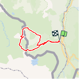
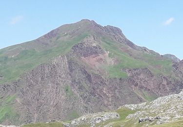
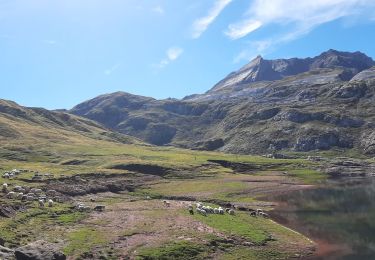
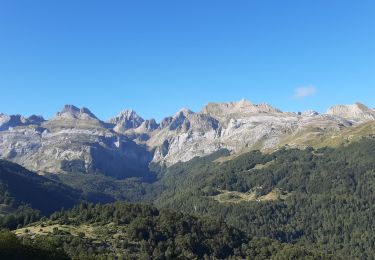
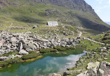
Pic de Gabedaille (2258m)en boucle par le col de la Contende et l'Escalé d'Aigue Torte Malgré son altitude modeste, le pic frontalier de Gabedaille (ou signal d'Espélunguère) constitue un exceptionnel belvédère. Peu de circuits aussi courts offrent à la fois une telle variété de paysages et un panorama aussi somptueux. Au sommet vous pourrez contempler : le Visaurin (tout près), el Castillo de Acher et son air de château fort, les Aiguilles d'Ansabère, La Tables des Trois Rois, le Pic d'Anie, les Orgues de Camplong, le Pic Labigouer, l'Ossau, le Pic des Moines, le Palas, Le Balaïtous, le lac d'Estaens, etc ...

Elevation profile

Photos

Positioning

Country:
France
Region :
New Aquitaine
Department/Province :
Pyrénées-Atlantiques
Municipality :
Borce
Location:
Unknown
Start:(UTM)
699255 ; 4743371 (30T) N.

Trails nearby

Trail On foot Urdos - Sentier de Peyranère au Refuge de Larry PNP - Photo
On foot
PRO

On foot

Easy
Urdos, New Aquitaine, Pyrénées-Atlantiques, France
10.4 km | 19.6 km-effort
4h 27min
No
Trail On foot Urdos - Sentier du Plateau de la Gentiane PNP - Photo
On foot
PRO

On foot

Easy
Urdos, New Aquitaine, Pyrénées-Atlantiques, France
3.6 km | 7.3 km-effort
1h 39min
No
Trail On foot Urdos - Sentier du Lac d'Estaëns PNP - Photo
On foot
PRO

On foot

Easy
Urdos, New Aquitaine, Pyrénées-Atlantiques, France
5.1 km | 10.1 km-effort
2h 17min
No
Trail Walking Borce - Boucle Lescun 4J - E4 - Photo
Walking
veneon

Walking

Very easy
(1)
Borce, New Aquitaine, Pyrénées-Atlantiques, France
18 km | 27 km-effort
4h 59min
No
Trail Walking Borce - hrp Arlet to candanchu  - Photo
Walking
markloopt

Walking

Medium
(1)
Borce, New Aquitaine, Pyrénées-Atlantiques, France
21 km | 33 km-effort
9h 17min
No
Trail Walking Borce - Lac d'Estaens - Photo
Walking
bedous

Walking

Difficult
Borce, New Aquitaine, Pyrénées-Atlantiques, France
10.2 km | 18.3 km-effort
4h 10min
Yes
Trail Walking Urdos - Col d'Ayous depuis Urdos - Photo
Walking
bedous

Walking

Difficult
Urdos, New Aquitaine, Pyrénées-Atlantiques, France
14.6 km | 29 km-effort
6h 53min
Yes
Trail Walking Urdos - Plateau de la gentiane - Photo
Walking
bedous

Walking

Medium
Urdos, New Aquitaine, Pyrénées-Atlantiques, France
7.7 km | 13.2 km-effort
3h 18min
Yes
Trail Walking Jaca - Astun au refuge d'Ayous - Photo
Walking
bedous

Walking

Difficult
Jaca, Aragon, Huesca, Spain
16.1 km | 29 km-effort
7h 29min
Yes


Close
My subscriptions