Trail Walking Sare - Altxanga - Photo
 tracegps
tracegps

User

© OpenStreetMap contributors
Length
Length
9.2 km
Max alt
Max alt
552 m
Uphill gradient
Uphill gradient
528 m
Km-Effort
Km-Effort  
16.2 km
Min alt
Min alt
98 m
Downhill gradient
Downhill gradient
525 m
Boucle
Boucle
Yes
Creation date :
2014-12-10 00:00:00.0
Updated on :
2014-12-10 00:00:00.0

(1 Reviews)

Walking
Walking
2h40
Difficulty : Medium

Scan this QR Code to open this trail in the SityTrail application

FREE GPS app for hiking

Logo SityTrail SityTrail

IGN / Geographical institutes

Download SityTrail from the App Store Download SityTrail from Google Play

Logo SityTrail SityTrail World

The world is yours!

Download SityTrail from the App Store Download SityTrail from Google Play Download SityTrail on Huawei AppGallery

About

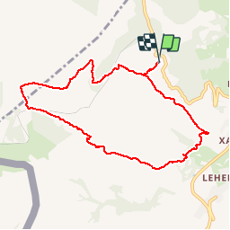
Trail Walking of 9.2 km to be discovered at New Aquitaine, Pyrénées-Atlantiques, Sare. This trail is proposed by tracegps.

Description

Du col de Saint Ignace vers Sare. A 620m du col prendre à droite puis à gauche et laisser la voiture au bout de la route suivre le chemin balisé "autour de Sare". Belle boucle avec vue sur le bassin de Sare et le massif de la Rhune, visite d'une redoute en forme d'étoile.

Elevation profile

Photos

Positioning

Country:
France
Region :
New Aquitaine
Department/Province :
Pyrénées-Atlantiques
Municipality :
Sare
Location:
Unknown
Start:(UTM)
613568 ; 4797379 (30T) N.

Comments

Please log in to post a review or rate the element


Trails nearby

Trail Walking Ascain - ascain Sare ascain - Photo
Walking
RayFab

Walking

Medium
(1)
Ascain, New Aquitaine, Pyrénées-Atlantiques, France
18.8 km | 27 km-effort
4h 39min
Yes
Trail Walking Sare - sare - Photo
Walking
JPLACANAU

Walking

Very easy
(1)
Sare, New Aquitaine, Pyrénées-Atlantiques, France
6.6 km | 8.9 km-effort
2h 22min
No
Trail Walking Urrugne - Montagne de Ciboure - Trabenea - Photo
Walking
tracegps

Walking

Medium
(2)
Urrugne, New Aquitaine, Pyrénées-Atlantiques, France
8.6 km | 13.3 km-effort
2h 30min
Yes
Trail Walking Saint-Pée-sur-Nivelle - Uhartea 22   - Photo
Walking
tracegps

Walking

Very difficult
(1)
Saint-Pée-sur-Nivelle, New Aquitaine, Pyrénées-Atlantiques, France
22 km | 31 km-effort
7h 0min
Yes
Trail Nordic walking Saint-Pée-sur-Nivelle - Eric Saint Pé Les bergeries  - Photo
Nordic walking
oger_eric

Nordic walking

Medium
(1)
Saint-Pée-sur-Nivelle, New Aquitaine, Pyrénées-Atlantiques, France
15.3 km | 20 km-effort
4h 4min
No
Trail Walking Sare - La rhune par la face EST - Photo
Walking
DECHAMPD

Walking

Medium
(1)
Sare, New Aquitaine, Pyrénées-Atlantiques, France
13.8 km | 26 km-effort
5h 10min
Yes
Trail Walking Sare - sare les palombieres - Photo
Walking
GUIDE
antignacs

Walking

Easy
Sare, New Aquitaine, Pyrénées-Atlantiques, France
15.8 km | 24 km-effort
4h 44min
Yes
Trail Walking Sare - la rhune depuis Sare (2) - Photo
Walking
jcaudron

Walking

Very easy
(4)
Sare, New Aquitaine, Pyrénées-Atlantiques, France
13.9 km | 26 km-effort
4h 0min
Yes
Trail Walking Urrugne - rhune - Photo
Walking
phil331

Walking

Medium
(1)
Urrugne, New Aquitaine, Pyrénées-Atlantiques, France
11.9 km | 24 km-effort
4h 43min
Yes


Close
My subscriptions