Trail Walking Steenwerck - Circuit du Pont de Pierre - Steenwerck - Photo

Circuit du Pont de Pierre - Steenwerck

 tracegps
tracegps

User

© OpenStreetMap contributors
Length
Length
12.2 km
Max alt
Max alt
21 m
Uphill gradient
Uphill gradient
42 m
Km-Effort
Km-Effort  
12.7 km
Min alt
Min alt
13 m
Downhill gradient
Downhill gradient
41 m
Boucle
Boucle
Yes
Creation date :
2014-12-10 00:00:00.0
Updated on :
2014-12-10 00:00:00.0

(0 Reviews)

Walking
Walking
3h15
Difficulty : Difficult

Scan this QR Code to open this trail in the SityTrail application

FREE GPS app for hiking

Logo SityTrail SityTrail

IGN / Geographical institutes

Download SityTrail from the App Store Download SityTrail from Google Play

Logo SityTrail SityTrail World

The world is yours!

Download SityTrail from the App Store Download SityTrail from Google Play Download SityTrail on Huawei AppGallery

About

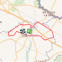
Trail Walking of 12.2 km to be discovered at Hauts-de-France, Nord, Steenwerck. This trail is proposed by tracegps.

Description

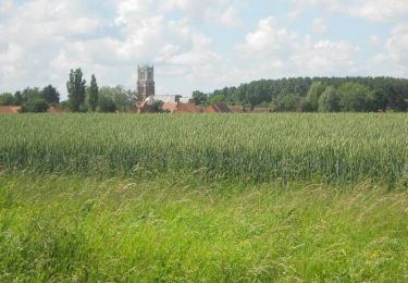
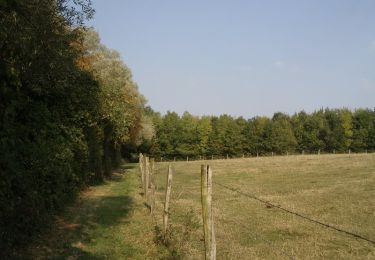
Circuit du Pont de Pierre. Départ du musée de la vie rurale à Steenwerck. La longueur dédie l’itinéraire au promeneur habitué à la marche d’une demi-journée mais est sans égale avec les 100 km de Steenwerck organisés sur la commune. Le Musée de la Vie Rurale complètera la connaissance de la campagne flamande et restaurera le randonneur fatigué ou assoiffé. Retrouvez cette randonnée sur le site du Comité Départemental du Tourisme du Nord.

Elevation profile

Photos

Positioning

Country:
France
Region :
Hauts-de-France
Department/Province :
Nord
Municipality :
Steenwerck
Location:
Unknown
Start:(UTM)
483841 ; 5616456 (31U) N.

Trails nearby

Trail On foot Sailly-sur-la-Lys - Chemin Champêtre - Photo
On foot
PRO

On foot

Easy
Sailly-sur-la-Lys, Hauts-de-France, Pas-de-Calais, France
9.1 km | 9.7 km-effort
2h 11min
No
Trail On foot Sailly-sur-la-Lys - Chemin de l’Alloeu - Photo
On foot
PRO

On foot

Easy
Sailly-sur-la-Lys, Hauts-de-France, Pas-de-Calais, France
3.6 km | 3.7 km-effort
50min
Yes
Trail On foot Sailly-sur-la-Lys - Chemin des Sûres - Photo
On foot
PRO

On foot

Easy
Sailly-sur-la-Lys, Hauts-de-France, Pas-de-Calais, France
5.3 km | 5.5 km-effort
1h 14min
No
Trail Motor Bailleul - 104 - Photo
Motor
abalcerek

Motor

Very easy
(3)
Bailleul, Hauts-de-France, Nord, France
127 km | 140 km-effort
3h 49min
No
Trail Walking Sailly-sur-la-Lys - Chemin Champêtre - Sailly-sur-la-Lys - Photo
Walking
Blourouce

Walking

Medium
(1)
Sailly-sur-la-Lys, Hauts-de-France, Pas-de-Calais, France
9.7 km | 10.3 km-effort
2h 18min
Yes
Trail Walking Sailly-sur-la-Lys - Chemin Champêtre - Sailly sur la Lys - Photo
Walking
tracegps

Walking

Medium
Sailly-sur-la-Lys, Hauts-de-France, Pas-de-Calais, France
9.7 km | 10.3 km-effort
2h 30min
Yes
Trail Walking Sailly-sur-la-Lys - Chemin de l'Alloeu - Sailly sur la Lys - Photo
Walking
tracegps

Walking

Easy
Sailly-sur-la-Lys, Hauts-de-France, Pas-de-Calais, France
4 km | 4.1 km-effort
1h 0min
Yes
Trail Running Bailleul - bailleul - Photo
Running
jamboxland

Running

Easy
Bailleul, Hauts-de-France, Nord, France
14.4 km | 16.6 km-effort
1h 20min
Yes
Trail Walking Bailleul - Sentier du Ravensberg - Bailleul - Photo
Walking
tracegps

Walking

Difficult
Bailleul, Hauts-de-France, Nord, France
14.4 km | 16.8 km-effort
3h 40min
Yes


Close
My subscriptions