Trail Walking Saint-Chéron - Autour de Saint Chéron - Photo

Autour de Saint Chéron

 tracegps
tracegps

User

© OpenStreetMap contributors
Length
Length
23 km
Max alt
Max alt
164 m
Uphill gradient
Uphill gradient
430 m
Km-Effort
Km-Effort  
29 km
Min alt
Min alt
60 m
Downhill gradient
Downhill gradient
434 m
Boucle
Boucle
Yes
Creation date :
2014-12-10 00:00:00.0
Updated on :
2014-12-10 00:00:00.0

(1 Reviews)

Walking
Walking
4h49
Difficulty : Difficult

Scan this QR Code to open this trail in the SityTrail application

FREE GPS app for hiking

Logo SityTrail SityTrail

IGN / Geographical institutes

Download SityTrail from the App Store Download SityTrail from Google Play

Logo SityTrail SityTrail World

The world is yours!

Download SityTrail from the App Store Download SityTrail from Google Play Download SityTrail on Huawei AppGallery

About

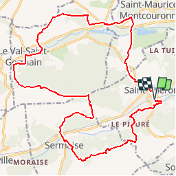
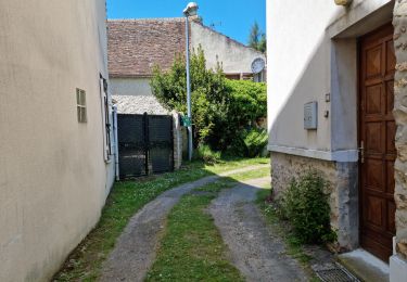
Trail Walking of 23 km to be discovered at Ile-de-France, Essonne, Saint-Chéron. This trail is proposed by tracegps.

Description

Circuit proposé par le Comité Départemental de Randonnée des Hauts de Seine. Particularité : Dénivelé 450m. Passage très délicat sur le GR1 au sud de Sermaise, modification du tracé pour arriver à Sermaise. Parking départ : gare ou mairie de Saint-Chéron . Descriptif : nb, Saint-Chéron gare, parc de l'Orge, Saint-Evroult (source et lavoir), la Guillotière, la Boissière ... GR1, Le Mesnil, Sermaise (église) ... PR, bois de la Bretonnière, Butte de Ville Pierreuse ... GRP, ferme des Sueurs, la Vieuville, leVal-Saint-Germain (14km) … nb, bois de Tous Vents ... GR111, les Rochettes de Granville, les Beaux Sablons, le Marais, cote 66 ...PR le Petit Bois ... GRP, Saint Chéron. Des sentiers ont pu être modifiés depuis la dernière validation et les itinéraires proposés n’engagent pas la responsabilité du Comité. Signalez-nous les modifications rencontrées pour mise à jour de la randothèque.

Elevation profile

Photos

Positioning

Country:
France
Region :
Ile-de-France
Department/Province :
Essonne
Municipality :
Saint-Chéron
Location:
Unknown
Start:(UTM)
435505 ; 5377930 (31U) N.

Comments

Please log in to post a review or rate the element


Bonne randonnée familiale


Trails nearby

Trail Walking Saint-Sulpice-de-Favières - Les Pétales de Souzy - Photo
Walking
tracegps

Walking

Difficult
(1)
Saint-Sulpice-de-Favières, Ile-de-France, Essonne, France
23 km | 29 km-effort
4h 49min
Yes
Trail Walking Saint-Sulpice-de-Favières - St Sulpice - Photo
Walking
Auger91

Walking

Medium
(1)
Saint-Sulpice-de-Favières, Ile-de-France, Essonne, France
8 km | 10.1 km-effort
2h 18min
Yes
Trail Walking Sermaise - 2018-09-26 Rando Sermaise - Photo
Walking
jchezlemas

Walking

Easy
(1)
Sermaise, Ile-de-France, Essonne, France
12.3 km | 15 km-effort
3h 15min
Yes
Trail Walking Villeconin - Villeconin - Photo
Walking
guydu41

Walking

Medium
Villeconin, Ile-de-France, Essonne, France
8.5 km | 10.9 km-effort
2h 11min
Yes
Trail Walking Saint-Sulpice-de-Favières - Saint-Sulpice-de-Favières - Photo
Walking
guydu41

Walking

Medium
Saint-Sulpice-de-Favières, Ile-de-France, Essonne, France
7.5 km | 9.4 km-effort
1h 55min
Yes
Trail Walking Souzy-la-Briche - Carrières de Madagascar à Souzy-la-Briche  - Photo
Walking
guydu41

Walking

Medium
Souzy-la-Briche, Ile-de-France, Essonne, France
6.8 km | 8.3 km-effort
1h 52min
Yes
Trail Walking Saint-Maurice-Montcouronne - Boucle St Maurice Montcouronne - Brigitte - Photo
Walking
chessyca

Walking

Very easy
Saint-Maurice-Montcouronne, Ile-de-France, Essonne, France
21 km | 24 km-effort
4h 19min
Yes
Trail On foot Saint-Sulpice-de-Favières - Randonnée Saint-Sulpice-de-Favieres n°2 - Photo
On foot
Jean Pierre Parent

On foot

Medium
Saint-Sulpice-de-Favières, Ile-de-France, Essonne, France
20 km | 25 km-effort
4h 51min
Yes
Trail Walking Souzy-la-Briche - Rumba à Souzy la briche - Photo
Walking
philou91

Walking

Easy
Souzy-la-Briche, Ile-de-France, Essonne, France
7.6 km | 9.3 km-effort
2h 29min
Yes


Close
My subscriptions