Trail Mountain bike Sarrebourg - Circuit VTT de la Zone de Loisirs - Sarrebourg - Photo

Circuit VTT de la Zone de Loisirs - Sarrebourg

 tracegps
tracegps

User

© OpenStreetMap contributors
Length
Length
4.6 km
Max alt
Max alt
287 m
Uphill gradient
Uphill gradient
57 m
Km-Effort
Km-Effort  
5.3 km
Min alt
Min alt
244 m
Downhill gradient
Downhill gradient
55 m
Boucle
Boucle
Yes
Creation date :
2014-12-10 00:00:00.0
Updated on :
2014-12-10 00:00:00.0

(0 Reviews)

Mountain bike
Mountain bike
30m
Difficulty : Easy

Scan this QR Code to open this trail in the SityTrail application

FREE GPS app for hiking

Logo SityTrail SityTrail

IGN / Geographical institutes

Download SityTrail from the App Store Download SityTrail from Google Play

Logo SityTrail SityTrail World

The world is yours!

Download SityTrail from the App Store Download SityTrail from Google Play Download SityTrail on Huawei AppGallery

About

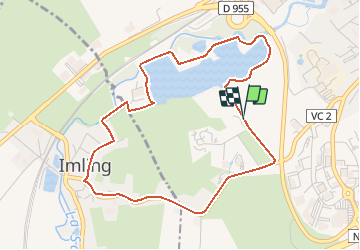
Trail Mountain bike of 4.6 km to be discovered at Grand Est, Moselle, Sarrebourg. This trail is proposed by tracegps.

Description

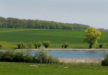
Le circuit part de la piscine vers l’étang de la ville et le contourne par la droite. Après le Lieu-dit Moulin Rouge, tourner à droite en direction du village d’Imling. Emprunter la première rue à gauche, assez raide, puis traverser une partie du village jusqu’au carrefour. Continuer à gauche en direction du lieu-dit Le Château. Suivre la route bordée de tilleuls à partir de laquelle on peut apercevoir les crêtes vosgiennes puis regagner la Zone de loisirs.

Elevation profile

Photos

Positioning

Country:
France
Region :
Grand Est
Department/Province :
Moselle
Municipality :
Sarrebourg
Location:
Unknown
Start:(UTM)
355690 ; 5398605 (32U) N.

Trails nearby

Trail Cycle Sarrebourg - Aux portes de Sarrebourg, le Pays des Grands Etangs - Sarrebourg - Circuit 20 - Photo
Cycle
tracegps

Cycle

Difficult
Sarrebourg, Grand Est, Moselle, France
59 km | 69 km-effort
3h 30min
Yes
Trail Walking Dolving - 2022-05-25-Circuit St Ulrich - Photo
Walking
milou1941

Walking

Easy
Dolving, Grand Est, Moselle, France
4.8 km | 5.9 km-effort
1h 20min
Yes
Trail Mountain bike Sarrebourg - Circuit VTT de Réding-Sarrebourg - Photo
Mountain bike
tracegps

Mountain bike

Difficult
Sarrebourg, Grand Est, Moselle, France
35 km | 42 km-effort
4h 0min
Yes
Trail Mountain bike Sarrebourg - Circuit VTT des Etangs de Rinting - Photo
Mountain bike
tracegps

Mountain bike

Difficult
Sarrebourg, Grand Est, Moselle, France
26 km | 31 km-effort
2h 30min
Yes
Trail Mountain bike Sarrebourg - Circuit VTT de la Vallée de la Sarre -Sarrebourg - Photo
Mountain bike
tracegps

Mountain bike

Medium
(1)
Sarrebourg, Grand Est, Moselle, France
18.9 km | 23 km-effort
1h 30min
Yes
Trail Motorbike Sarrebourg - export-route-des-cretes-cols-vosgiens - Photo
Motorbike
HG74250

Motorbike

Very easy
Sarrebourg, Grand Est, Moselle, France
449 km | 571 km-effort
Unknown
No
Trail Mountain bike Bébing - Bebing-Walscheid-Mont Ste Odile en VTT - Photo
Mountain bike
bbazin

Mountain bike

Difficult
Bébing, Grand Est, Moselle, France
72 km | 97 km-effort
6h 40min
No
Trail Bicycle tourism Hesse - Boucle Hesse - Abreschviller - Sarrebourg - Photo
Bicycle tourism
nfranche

Bicycle tourism

Medium
Hesse, Grand Est, Moselle, France
49 km | 56 km-effort
Unknown
Yes
Trail Cycle Hesse - piste cyclable, Alexis - Photo
Cycle
fredodlageo

Cycle

Easy
Hesse, Grand Est, Moselle, France
27 km | 31 km-effort
1h 45min
Yes


Close
My subscriptions