Trail Walking Castelculier - Saint-Amans / Saint-Ferréol, deux églises en Agenais - Pays de l'Agenais - Photo

Saint-Amans / Saint-Ferréol, deux églises en Agenais - Pays de l'Agenais

 tracegps
tracegps

User

© OpenStreetMap contributors
Length
Length
11.1 km
Max alt
Max alt
175 m
Uphill gradient
Uphill gradient
292 m
Km-Effort
Km-Effort  
15 km
Min alt
Min alt
64 m
Downhill gradient
Downhill gradient
290 m
Boucle
Boucle
Yes
Creation date :
2014-12-10 00:00:00.0
Updated on :
2014-12-10 00:00:00.0

(1 Reviews)

Walking
Walking
3h00
Difficulty : Medium

Scan this QR Code to open this trail in the SityTrail application

FREE GPS app for hiking

Logo SityTrail SityTrail

IGN / Geographical institutes

Download SityTrail from the App Store Download SityTrail from Google Play

Logo SityTrail SityTrail World

The world is yours!

Download SityTrail from the App Store Download SityTrail from Google Play Download SityTrail on Huawei AppGallery

About

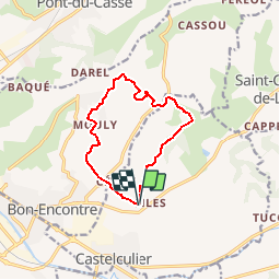
Trail Walking of 11.1 km to be discovered at New Aquitaine, Lot-et-Garonne, Castelculier. This trail is proposed by tracegps.

Description

Saint Amans Com. Castelculier / Saint Ferréol Com. Bon Encontre Ce circuit qui relie deux églises isolées dans la campagne agenaise traverse deux fois la profonde et étroite vallée du Mondot. Ceci promet de belles montées, mais l’effort sera récompensé par les points de vue offerts sur la vallée de la Garonne… Téléchargez la fiche de cette randonnée sur le site du Tourisme du Lot et Garonne. Villascopia, le spectacle de la vie gallo-romaine par CDT47

Elevation profile

Photos

Positioning

Country:
France
Region :
New Aquitaine
Department/Province :
Lot-et-Garonne
Municipality :
Castelculier
Location:
Unknown
Start:(UTM)
316134 ; 4895187 (31T) N.

Comments

Please log in to post a review or rate the element


très bien


Trails nearby

Trail Mountain bike Lafox - super rando du mercredi - Photo
Mountain bike
wardom

Mountain bike

Difficult
(1)
Lafox, New Aquitaine, Lot-et-Garonne, France
21 km | 26 km-effort
1h 29min
Yes
Trail Mountain bike Castelculier - Rando VTT Amans - Laroque Timbaut et le bois de Courties - Agen Bon Encontre - Photo
Mountain bike
tracegps

Mountain bike

Difficult
Castelculier, New Aquitaine, Lot-et-Garonne, France
40 km | 50 km-effort
2h 30min
Yes
Trail Mountain bike Sauveterre-Saint-Denis - Sauveterre St Denis - Photo
Mountain bike
tracegps

Mountain bike

Medium
Sauveterre-Saint-Denis, New Aquitaine, Lot-et-Garonne, France
30 km | 34 km-effort
2h 0min
Yes
Trail Walking Sauveterre-Saint-Denis - Sauveterre St Denis - Photo
Walking
tracegps

Walking

Very difficult
Sauveterre-Saint-Denis, New Aquitaine, Lot-et-Garonne, France
30 km | 34 km-effort
6h 0min
Yes
Trail Equestrian Saint-Pierre-de-Clairac - Saint-Pierre-de-Clairac, dans la vallée de la Séoune - Pays de l'Agenais - Photo
Equestrian
tracegps

Equestrian

Medium
Saint-Pierre-de-Clairac, New Aquitaine, Lot-et-Garonne, France
10 km | 12.1 km-effort
1h 40min
Yes
Trail Mountain bike Saint-Pierre-de-Clairac - Saint-Pierre-de-Clairac, dans la vallée de la Séoune - Pays de l'Agenais - Photo
Mountain bike
tracegps

Mountain bike

Medium
Saint-Pierre-de-Clairac, New Aquitaine, Lot-et-Garonne, France
10 km | 12.1 km-effort
1h 15min
Yes
Trail Walking Saint-Pierre-de-Clairac - Saint-Pierre-de-Clairac, dans la vallée de la Séoune - Pays de l'Agenais - Photo
Walking
tracegps

Walking

Medium
Saint-Pierre-de-Clairac, New Aquitaine, Lot-et-Garonne, France
10 km | 12.1 km-effort
2h 40min
Yes
Trail Mountain bike Saint-Jean-de-Thurac - Saint-Jean-de-Thurac, du canal aux coteaux de Serres - Pays de l'Agenais - Photo
Mountain bike
tracegps

Mountain bike

Medium
Saint-Jean-de-Thurac, New Aquitaine, Lot-et-Garonne, France
7.1 km | 9.9 km-effort
1h 10min
Yes
Trail Walking Saint-Jean-de-Thurac - Saint-Jean-de-Thurac, du canal aux coteaux de Serres - Pays de l'Agenais - Photo
Walking
tracegps

Walking

Medium
Saint-Jean-de-Thurac, New Aquitaine, Lot-et-Garonne, France
7.1 km | 9.9 km-effort
2h 15min
Yes


Close
My subscriptions