Trail Walking Marcilhac-sur-Célé - La ronde des Dolmens - Marcilhac sur Célé - Photo

La ronde des Dolmens - Marcilhac sur Célé

 tracegps
tracegps

User

© OpenStreetMap contributors
Length
Length
17.7 km
Max alt
Max alt
395 m
Uphill gradient
Uphill gradient
396 m
Km-Effort
Km-Effort  
23 km
Min alt
Min alt
151 m
Downhill gradient
Downhill gradient
396 m
Boucle
Boucle
Yes
Creation date :
2014-12-10 00:00:00.0
Updated on :
2014-12-10 00:00:00.0

(1 Reviews)

Walking
Walking
6h00
Difficulty : Medium

Scan this QR Code to open this trail in the SityTrail application

FREE GPS app for hiking

Logo SityTrail SityTrail

IGN / Geographical institutes

Download SityTrail from the App Store Download SityTrail from Google Play

Logo SityTrail SityTrail World

The world is yours!

Download SityTrail from the App Store Download SityTrail from Google Play Download SityTrail on Huawei AppGallery

About

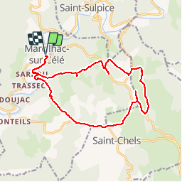
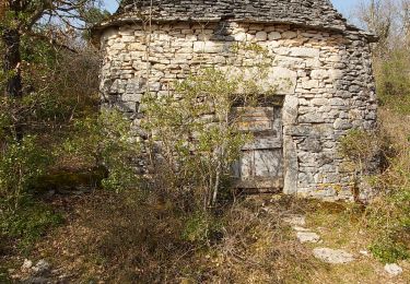
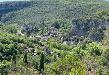
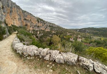
Trail Walking of 17.7 km to be discovered at Occitania, Lot, Marcilhac-sur-Célé. This trail is proposed by tracegps.

Description

Une boucle entre Marcilhac sur Célé et St Chels pour découvrir huit dolmens cachés dans le causse.

Elevation profile

Photos

Positioning

Country:
France
Region :
Occitania
Department/Province :
Lot
Municipality :
Marcilhac-sur-Célé
Location:
Unknown
Start:(UTM)
402396 ; 4934075 (31T) N.

Comments

Please log in to post a review or rate the element


Trails nearby

Trail Walking Brengues - brengues-7854558 - Photo
Walking
houbart

Walking

Difficult
(1)
Brengues, Occitania, Lot, France
11.9 km | 16.5 km-effort
3h 45min
Yes
Trail Walking Marcilhac-sur-Célé - Marcilhac sur Célé - Photo
Walking
tracegps

Walking

Medium
(2)
Marcilhac-sur-Célé, Occitania, Lot, France
8.4 km | 10.8 km-effort
3h 15min
Yes
Trail Walking Marcilhac-sur-Célé - Autour de Marcilhac sur Célé - Photo
Walking
tracegps

Walking

Very difficult
(2)
Marcilhac-sur-Célé, Occitania, Lot, France
17.8 km | 25 km-effort
5h 0min
Yes
Trail Walking Marcilhac-sur-Célé - Marcilhac st sulpice  - Photo
Walking
GUIDE
antignacs

Walking

Medium
Marcilhac-sur-Célé, Occitania, Lot, France
20 km | 27 km-effort
5h 0min
Yes
Trail Walking Sauliac-sur-Célé - Sauliac sur céle Cabreret en boucle  - Photo
Walking
Gaillard Isabelle

Walking

Easy
(1)
Sauliac-sur-Célé, Occitania, Lot, France
19.9 km | 28 km-effort
5h 52min
Yes
Trail Walking Marcilhac-sur-Célé - Marcilhac-sur-Célé - Boucle - Photo
Walking
Indi34

Walking

Easy
Marcilhac-sur-Célé, Occitania, Lot, France
7.9 km | 10.8 km-effort
3h 3min
Yes
Trail sport Marcilhac-sur-Célé - 20240420 Marcilhac - Cabrerets  - Photo
sport
ThonyM

sport

Very easy
Marcilhac-sur-Célé, Occitania, Lot, France
22 km | 30 km-effort
Unknown
No
Trail Walking Marcilhac-sur-Célé - Marcilhac-sur-Célé  - Photo
Walking
thomas.o.vert

Walking

Easy
Marcilhac-sur-Célé, Occitania, Lot, France
7.4 km | 9.8 km-effort
2h 13min
Yes
Trail Walking Sauliac-sur-Célé - Sauliac Monteils Blars  - Photo
Walking
GUIDE
antignacs

Walking

Easy
Sauliac-sur-Célé, Occitania, Lot, France
17.1 km | 24 km-effort
4h 21min
Yes


Close
My subscriptions