Trail Walking Nérac - Nérac, la balade de Nazareth - Pays d'Albret - Photo

Nérac, la balade de Nazareth - Pays d'Albret

 tracegps
tracegps

User

© OpenStreetMap contributors
Length
Length
10.7 km
Max alt
Max alt
182 m
Uphill gradient
Uphill gradient
163 m
Km-Effort
Km-Effort  
12.8 km
Min alt
Min alt
48 m
Downhill gradient
Downhill gradient
157 m
Boucle
Boucle
Yes
Creation date :
2014-12-10 00:00:00.0
Updated on :
2014-12-10 00:00:00.0

(0 Reviews)

Walking
Walking
2h30
Difficulty : Medium

Scan this QR Code to open this trail in the SityTrail application

FREE GPS app for hiking

Logo SityTrail SityTrail

IGN / Geographical institutes

Download SityTrail from the App Store Download SityTrail from Google Play

Logo SityTrail SityTrail World

The world is yours!

Download SityTrail from the App Store Download SityTrail from Google Play Download SityTrail on Huawei AppGallery

About

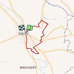
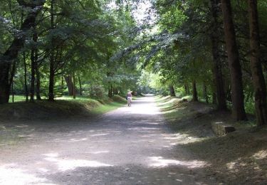
Trail Walking of 10.7 km to be discovered at New Aquitaine, Lot-et-Garonne, Nérac. This trail is proposed by tracegps.

Description

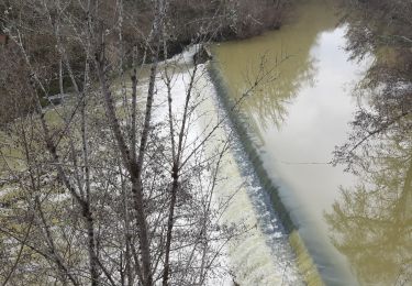
Nérac, la balade de Nazareth - Pays d'Albret. Nérac / Le Cauze Communauté de Communes du Val d’Albret Cet itinéraire qui traverse la Capitale de l’Albret présente le Val de Baïse des coteaux à la plaine. Point de vue sur la ville, panoramas sur de larges paysages, fenêtres sur la rivière : regardez ! Téléchargez la fiche de cette randonnée sur le site du Tourisme du Lot et Garonne.

Elevation profile

Photos

Positioning

Country:
France
Region :
New Aquitaine
Department/Province :
Lot-et-Garonne
Municipality :
Nérac
Location:
Unknown
Start:(UTM)
287356 ; 4890277 (31T) N.

Trails nearby

Trail Walking Barbaste - Cauderoue et Ste-Catherine, les pieds dans la Gélise - Pays d'Albret - Photo
Walking
tracegps

Walking

Medium
(1)
Barbaste, New Aquitaine, Lot-et-Garonne, France
6.8 km | 8.5 km-effort
2h 0min
Yes
Trail Walking Nérac - Gélise, frontière des sables - Pays d'Albret - Photo
Walking
tracegps

Walking

Medium
(1)
Nérac, New Aquitaine, Lot-et-Garonne, France
10.2 km | 12.7 km-effort
2h 30min
Yes
Trail On foot Nérac - Mézin, vers Nérac, avec le petit train touristique 19.6 km - Photo
On foot
PRO

On foot

Medium
Nérac, New Aquitaine, Lot-et-Garonne, France
17.3 km | 21 km-effort
4h 42min
No
Trail Walking Barbaste - Cauderoue Ste Catherine Cauderoue - Photo
Walking
Forsans

Walking

Easy
Barbaste, New Aquitaine, Lot-et-Garonne, France
6.4 km | 8.3 km-effort
2h 6min
Yes
Trail On foot Lasserre - Fieux, panoramas de Gascogne - 14.5 km - Photo
On foot
PRO

On foot

Easy
Lasserre, New Aquitaine, Lot-et-Garonne, France
14.4 km | 19 km-effort
4h 19min
Yes
Trail On foot Espiens - Espiens, dans les coteaux, vers le château de Salles - 10.7km - Photo
On foot
PRO

On foot

Easy
Espiens, New Aquitaine, Lot-et-Garonne, France
9 km | 11.8 km-effort
2h 40min
No
Trail Walking Barbaste - Cauderoue Barbaste boucle - Photo
Walking
Forsans

Walking

Very easy
Barbaste, New Aquitaine, Lot-et-Garonne, France
8 km | 10.2 km-effort
2h 9min
Yes
Trail Mountain bike Nérac - Nérac, via Puy Fort Eguille et Nazareth - Photo
Mountain bike
tracegps

Mountain bike

Medium
Nérac, New Aquitaine, Lot-et-Garonne, France
17.7 km | 22 km-effort
2h 19min
Yes
Trail Walking Nérac - Nérac, via Puy Fort Eguille et Nazareth - Photo
Walking
tracegps

Walking

Difficult
Nérac, New Aquitaine, Lot-et-Garonne, France
17.7 km | 22 km-effort
4h 40min
Yes


Close
My subscriptions