Trail Snowshoes Châtel - Petite  Châtel - Photo
 pascalou73
pascalou73

User GUIDE

© OpenStreetMap contributors
Length
Length
5.7 km
Max alt
Max alt
1633 m
Uphill gradient
Uphill gradient
368 m
Km-Effort
Km-Effort  
10.6 km
Min alt
Min alt
1269 m
Downhill gradient
Downhill gradient
367 m
Boucle
Boucle
Yes
Creation date :
2019-05-06 16:38:23.786
Updated on :
2019-05-06 16:38:23.786

(0 Reviews)

Snowshoes
Snowshoes
2h00
Difficulty : Medium

Scan this QR Code to open this trail in the SityTrail application

FREE GPS app for hiking

Logo SityTrail SityTrail

IGN / Geographical institutes

Download SityTrail from the App Store Download SityTrail from Google Play

Logo SityTrail SityTrail World

The world is yours!

Download SityTrail from the App Store Download SityTrail from Google Play Download SityTrail on Huawei AppGallery

About

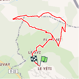
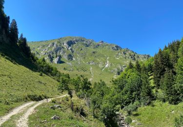
Trail Snowshoes of 5.7 km to be discovered at Auvergne-Rhône-Alpes, Upper Savoy, Châtel. This trail is proposed by pascalou73.

Description

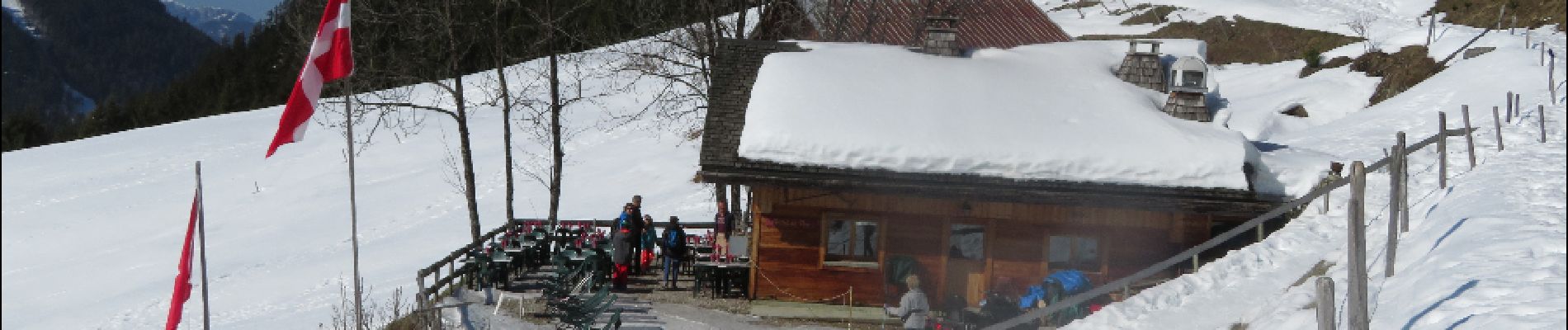
Une belle randonnée sur châtel .Avec une Buvette

Elevation profile

Photos

Points of interest

Point of interest Châtel - petit chatel - Photo
pascalou73
CHÂTEL 
Point of interest Châtel - petit chatel - Photo
pascalou73
CHÂTEL 
Point of interest La Chapelle-d'Abondance - petit chatel - Photo
pascalou73
LA CHAPELLE-D'ABONDANCE 

Positioning

Country:
France
Region :
Auvergne-Rhône-Alpes
Department/Province :
Upper Savoy
Municipality :
Châtel
Location:
Unknown
Start:(UTM)
333195 ; 5127389 (32T) N.

Trails nearby

Trail Walking La Chapelle-d'Abondance - Le Linleu 2093 m, depuis Sevan-devant - Photo
Walking
tracegps

Walking

Medium
(1)
La Chapelle-d'Abondance, Auvergne-Rhône-Alpes, Upper Savoy, France
5.1 km | 11.9 km-effort
3h 0min
Yes
Trail Walking La Chapelle-d'Abondance - Les Cornettes de Bise par le sentier de Saix Rouquin - Photo
Walking
tracegps

Walking

Difficult
(1)
La Chapelle-d'Abondance, Auvergne-Rhône-Alpes, Upper Savoy, France
10 km | 25 km-effort
6h 30min
Yes
Trail Walking La Chapelle-d'Abondance - Cascade boucle 2 - Photo
Walking
Derrendinger

Walking

Difficult
(1)
La Chapelle-d'Abondance, Auvergne-Rhône-Alpes, Upper Savoy, France
10.1 km | 14.9 km-effort
3h 23min
Yes
Trail On foot Vionnaz - Torgon village - Chalet de Blancsex - Photo
On foot
PRO

On foot

Easy
Vionnaz, Valais/Wallis, Monthey, Switzerland
4.4 km | 8.7 km-effort
1h 58min
No
Trail On foot Vionnaz - Torgon village - Dravers - Photo
On foot
PRO

On foot

Easy
Vionnaz, Valais/Wallis, Monthey, Switzerland
4 km | 8.3 km-effort
1h 53min
No
Trail Snowshoes Châtel - Randonnée entre la France et la suisse  - Photo
Snowshoes
GUIDE
pascalou73

Snowshoes

Easy
Châtel, Auvergne-Rhône-Alpes, Upper Savoy, France
5.8 km | 8.5 km-effort
2h 3min
Yes
Trail Walking Châtel - Les Mattes - Photo
Walking
mlienhart

Walking

Difficult
Châtel, Auvergne-Rhône-Alpes, Upper Savoy, France
11.1 km | 22 km-effort
5h 42min
Yes
Trail Snowshoes Châtel - les Québales - Photo
Snowshoes
GUIDE
pascalou73

Snowshoes

Difficult
Châtel, Auvergne-Rhône-Alpes, Upper Savoy, France
3 km | 8.4 km-effort
2h 0min
No
Trail Walking Troistorrents - Morgins - circuit Bonavau, La Truche,La Foilleuse, Savolaire 29.09.18 - Photo
Walking
duamerg

Walking

Medium
Troistorrents, Valais/Wallis, Monthey, Switzerland
15.1 km | 23 km-effort
4h 50min
Yes


Close
My subscriptions