Trail Walking Coarraze - Circuit des Serres - Coarraze - Photo

Circuit des Serres - Coarraze

 tracegps
tracegps

User

© OpenStreetMap contributors
Length
Length
8.7 km
Max alt
Max alt
468 m
Uphill gradient
Uphill gradient
220 m
Km-Effort
Km-Effort  
11.7 km
Min alt
Min alt
300 m
Downhill gradient
Downhill gradient
217 m
Boucle
Boucle
Yes
Creation date :
2014-12-10 00:00:00.0
Updated on :
2014-12-10 00:00:00.0

(0 Reviews)

Walking
Walking
2h07
Difficulty : Medium

Scan this QR Code to open this trail in the SityTrail application

FREE GPS app for hiking

Logo SityTrail SityTrail

IGN / Geographical institutes

Download SityTrail from the App Store Download SityTrail from Google Play

Logo SityTrail SityTrail World

The world is yours!

Download SityTrail from the App Store Download SityTrail from Google Play Download SityTrail on Huawei AppGallery

About

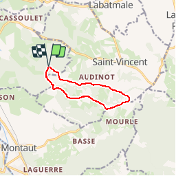
Trail Walking of 8.7 km to be discovered at New Aquitaine, Pyrénées-Atlantiques, Coarraze. This trail is proposed by tracegps.

Description

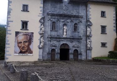
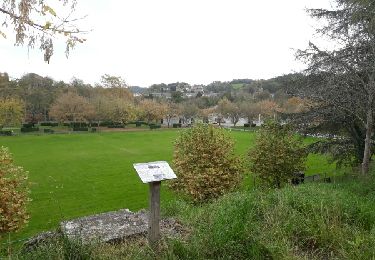
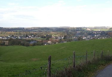
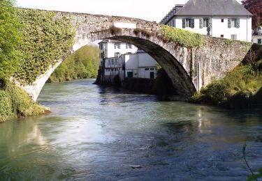
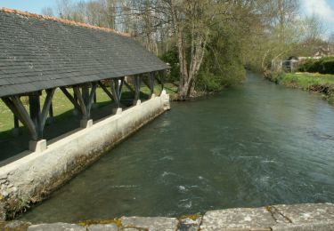
Au départ, le 7 février 2012, sur la commune de Coarraze, nous avons emprunté sur une courte distance quelques chemins défoncés par les engins d'exploitation forestière. Les ornières, les flaques d'eau gelées et la boue ne manquaient pas car les parties ensoleillées commençaient à dégeler. Puis, on a pu débarrasser nos chaussures de la boue collante sur une courte portion goudronnée. Sur un chemin relativement propre et sur la commune de Saint-Vincent, une belle côte nous attendait. Au sommet, on a pu admirer un superbe panorama sur les Pyrénées très enneigées. Entre nous et la chaîne, nous avions la grande forêt de Mourle qui va jusqu'au Lac de Lourdes. Pour terminer la journée, une longue descente, le long du Lagoin, souvent dans l'ombre, et parfois avec du verglas, nous a permis de rejoindre le point de départ.

Elevation profile

Positioning

Country:
France
Region :
New Aquitaine
Department/Province :
Pyrénées-Atlantiques
Municipality :
Coarraze
Location:
Unknown
Start:(UTM)
728893 ; 4782384 (30T) N.

Trails nearby

Trail Walking Lestelle-Bétharram - 2023 10 10 CHEMIN du PIÉMONT PYRÉNÉEN - 18ème étape : Lestelle-Bétharram - Asson - Bruges - Mifaget - Ste Colome - Arudy - Photo
Walking
LEGUE

Walking

Medium
Lestelle-Bétharram, New Aquitaine, Pyrénées-Atlantiques, France
28 km | 36 km-effort
6h 9min
No
Trail Walking Labatmale - gr782 - Photo
Walking
GUIDE
marmotte65

Walking

Medium
Labatmale, New Aquitaine, Pyrénées-Atlantiques, France
5.4 km | 6.1 km-effort
1h 28min
No
Trail Walking Lestelle-Bétharram - LESTELLE BETHARRAM entre amis - Photo
Walking
GUIDE
marmotte65

Walking

Very easy
Lestelle-Bétharram, New Aquitaine, Pyrénées-Atlantiques, France
9.5 km | 12.5 km-effort
2h 29min
Yes
Trail Walking Lestelle-Bétharram - grottes - Photo
Walking
pilgrim08

Walking

Medium
Lestelle-Bétharram, New Aquitaine, Pyrénées-Atlantiques, France
11 km | 14 km-effort
2h 14min
Yes
Trail Walking Coarraze - CHEMIN DES SERRES - Photo
Walking
marche64110

Walking

Medium
(1)
Coarraze, New Aquitaine, Pyrénées-Atlantiques, France
8.7 km | 11.6 km-effort
2h 38min
Yes
Trail Walking Lestelle-Bétharram - Ballade Lestelle-betharram - Photo
Walking
pilgrim08

Walking

Very easy
Lestelle-Bétharram, New Aquitaine, Pyrénées-Atlantiques, France
6.5 km | 7.8 km-effort
1h 30min
Yes
Trail Walking Lestelle-Bétharram - croix des hauteurs - Photo
Walking
pilgrim08

Walking

Medium
Lestelle-Bétharram, New Aquitaine, Pyrénées-Atlantiques, France
5.8 km | 7.6 km-effort
1h 14min
Yes
Trail Walking Lestelle-Bétharram - Lestelle - Boucle des Bastides - Photo
Walking
tracegps

Walking

Medium
Lestelle-Bétharram, New Aquitaine, Pyrénées-Atlantiques, France
12.2 km | 16.3 km-effort
3h 0min
Yes
Trail Walking Igon - Boucle de l'Ouzom à Asson - Photo
Walking
tracegps

Walking

Medium
Igon, New Aquitaine, Pyrénées-Atlantiques, France
13 km | 16.4 km-effort
3h 30min
Yes


Close
My subscriptions