Trail Walking Taillades - taillades - Photo
© OpenStreetMap contributors
Length
Length
7.6 km
Max alt
Max alt
186 m
Uphill gradient
Uphill gradient
166 m
Km-Effort
Km-Effort  
9.8 km
Min alt
Min alt
99 m
Downhill gradient
Downhill gradient
166 m
Boucle
Boucle
Yes
Creation date :
2014-12-10 00:00:00.0
Updated on :
2014-12-10 00:00:00.0

(1 Reviews)

Walking
Walking
1h36
Difficulty : Unknown

Scan this QR Code to open this trail in the SityTrail application

FREE GPS app for hiking

Logo SityTrail SityTrail

IGN / Geographical institutes

Download SityTrail from the App Store Download SityTrail from Google Play

Logo SityTrail SityTrail World

The world is yours!

Download SityTrail from the App Store Download SityTrail from Google Play Download SityTrail on Huawei AppGallery

About

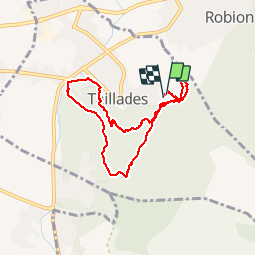
Trail Walking of 7.6 km to be discovered at Provence-Alpes-Côte d'Azur, Vaucluse, Taillades. This trail is proposed by fireman84.

Description

Petite rando courte et sympa à faire en famille

Elevation profile

Photos

Points of interest

Point of interest Cavaillon - Point 1 - Photo
fireman84
CAVAILLON 

Positioning

Country:
France
Region :
Provence-Alpes-Côte d'Azur
Department/Province :
Vaucluse
Municipality :
Taillades
Location:
Unknown
Start:(UTM)
668958 ; 4855627 (31T) N.

Comments

Please log in to post a review or rate the element


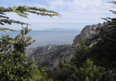
Très joli parcours, pas fatigant. En avril, thym et romarin en fleurs... Et les cystes commencent aussi... Champêtre !


Trails nearby

Trail Walking Robion - petit luberon - Photo
Walking
GUIDE
nadinebondoux

Walking

Difficult
(1)
Robion, Provence-Alpes-Côte d'Azur, Vaucluse, France
16.7 km | 27 km-effort
6h 23min
Yes
Trail Cycle Cavaillon - Autour du Luberon à vélo - Photo
Cycle
GUIDE+

Cycle

Difficult
(4)
Cavaillon, Provence-Alpes-Côte d'Azur, Vaucluse, France
236 km | 285 km-effort
15h 46min
Yes
Trail Cycle Cavaillon - Parcours n°3 - Cavaillon - Photo
Cycle
GUIDE+

Cycle

Easy
(2)
Cavaillon, Provence-Alpes-Côte d'Azur, Vaucluse, France
45 km | 50 km-effort
2h 55min
No
Trail Walking Oppède - PF-Oppède - Le Vallon de Combrès - Le Sautadou du Bausset - Photo
Walking
MicDul

Walking

Difficult
(1)
Oppède, Provence-Alpes-Côte d'Azur, Vaucluse, France
13.6 km | 23 km-effort
4h 45min
Yes
Trail Walking Taillades - Par la Gorge de Badarel et les Rochers de Baude - Photo
Walking
tracegps

Walking

Medium
(3)
Taillades, Provence-Alpes-Côte d'Azur, Vaucluse, France
8 km | 14.7 km-effort
4h 0min
Yes
Trail Walking Taillades - Les Taillades-De la source du Boulon au Castelas - Gorge de Badarel sous la neige - Photo
Walking
tracegps

Walking

Difficult
(1)
Taillades, Provence-Alpes-Côte d'Azur, Vaucluse, France
7 km | 10.8 km-effort
3h 0min
Yes
Trail Mountain bike Maubec - Luberon - Grande Traversée de Vaucluse - de Maubec / Robion à Mérindol - Photo
Mountain bike
GUIDE+

Mountain bike

Difficult
(1)
Maubec, Provence-Alpes-Côte d'Azur, Vaucluse, France
32 km | 42 km-effort
2h 47min
No
Trail Walking Taillades - Taillades Badarel  Brayette Robion - Photo
Walking
kephas

Walking

Difficult
(1)
Taillades, Provence-Alpes-Côte d'Azur, Vaucluse, France
10.6 km | 17.6 km-effort
3h 41min
Yes
Trail Walking Cheval-Blanc - bergerie/badarel - Photo
Walking
fireman84

Walking

Medium
(1)
Cheval-Blanc, Provence-Alpes-Côte d'Azur, Vaucluse, France
9.9 km | 16 km-effort
3h 20min
Yes


Close
My subscriptions