Trail Cycle Cavaillon - Parcours n°3 - Cavaillon - Photo

Randonnées de Vélo Loisir Provence GUIDE+

© OpenStreetMap contributors
Length
Length
45 km
Max alt
Max alt
195 m
Uphill gradient
Uphill gradient
419 m
Km-Effort
Km-Effort  
50 km
Min alt
Min alt
57 m
Downhill gradient
Downhill gradient
420 m
Boucle
Boucle
No
Creation date :
2015-01-07 00:00:00.0
Updated on :
2015-01-07 00:00:00.0

(2 Reviews)

Cycle
Cycle
2h55
Difficulty : Easy

Scan this QR Code to open this trail in the SityTrail application

FREE GPS app for hiking

Logo SityTrail SityTrail

IGN / Geographical institutes

Download SityTrail from the App Store Download SityTrail from Google Play

Logo SityTrail SityTrail World

The world is yours!

Download SityTrail from the App Store Download SityTrail from Google Play Download SityTrail on Huawei AppGallery

About

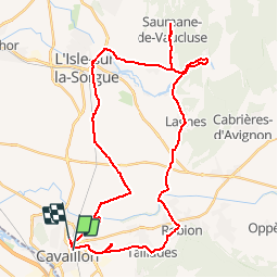
Trail Cycle of 45 km to be discovered at Provence-Alpes-Côte d'Azur, Vaucluse, Cavaillon. This trail is proposed by Vélo Loisir Provence.

Description

A superb itinerary which will take you from the slopes of the Petit Luberon to the Monts de Vaucluse with a stop at the absolutely unavoidable Fontaine de Vaucluse. Direction of the itinerary : Cavaillon => Les Taillades => Robion => Lagnes => Fontaine-de-Vaucluse => Saumane-de-Vaucluse => Isle-sur-la-Sorgue => Cavaillon

Elevation profile

Photos

Positioning

Country:
France
Region :
Provence-Alpes-Côte d'Azur
Department/Province :
Vaucluse
Municipality :
Cavaillon
Location:
Unknown
Start:(UTM)
664263 ; 4855543 (31T) N.

Comments

Please log in to post a review or rate the element


Trails nearby

Trail Cycle Cavaillon - Autour du Luberon à vélo - Photo
Cycle
GUIDE+

Cycle

Difficult
(4)
Cavaillon, Provence-Alpes-Côte d'Azur, Vaucluse, France
236 km | 285 km-effort
15h 46min
Yes
Trail Cycle Cavaillon - Parcours n°1 - Cavaillon - Photo
Cycle
GUIDE+

Cycle

Difficult
(2)
Cavaillon, Provence-Alpes-Côte d'Azur, Vaucluse, France
33 km | 41 km-effort
2h 21min
Yes
Trail Walking Taillades - Par la Gorge de Badarel et les Rochers de Baude - Photo
Walking
tracegps

Walking

Medium
(3)
Taillades, Provence-Alpes-Côte d'Azur, Vaucluse, France
8 km | 14.7 km-effort
4h 0min
Yes
Trail Walking Taillades - taillades - Photo
Walking
fireman84

Walking

Very easy
(1)
Taillades, Provence-Alpes-Côte d'Azur, Vaucluse, France
7.6 km | 9.8 km-effort
1h 36min
Yes
Trail Walking Taillades - Les Taillades-De la source du Boulon au Castelas - Gorge de Badarel sous la neige - Photo
Walking
tracegps

Walking

Difficult
(1)
Taillades, Provence-Alpes-Côte d'Azur, Vaucluse, France
7 km | 10.8 km-effort
3h 0min
Yes
Trail Walking Taillades - Taillades Badarel  Brayette Robion - Photo
Walking
kephas

Walking

Difficult
(1)
Taillades, Provence-Alpes-Côte d'Azur, Vaucluse, France
10.6 km | 17.6 km-effort
3h 41min
Yes
Trail Walking Cheval-Blanc - bergerie/badarel - Photo
Walking
fireman84

Walking

Medium
(1)
Cheval-Blanc, Provence-Alpes-Côte d'Azur, Vaucluse, France
9.9 km | 16 km-effort
3h 20min
Yes
Trail Mountain bike Cheval-Blanc - vidok vtt - Photo
Mountain bike
fireman84

Mountain bike

Difficult
(2)
Cheval-Blanc, Provence-Alpes-Côte d'Azur, Vaucluse, France
17.4 km | 24 km-effort
1h 36min
Yes
Trail Mountain bike Cavaillon - Foret des cêdres D+850m par veloroute Calavon - Photo
Mountain bike
ericberlin

Mountain bike

Very difficult
Cavaillon, Provence-Alpes-Côte d'Azur, Vaucluse, France
55 km | 66 km-effort
4h 35min
Yes


Close
My subscriptions