Trail Walking Boubers-sur-Canche - 7 km autour de Boubers sur Canche - Photo

7 km autour de Boubers sur Canche

 tracegps
tracegps

User

© OpenStreetMap contributors
Length
Length
6.8 km
Max alt
Max alt
126 m
Uphill gradient
Uphill gradient
88 m
Km-Effort
Km-Effort  
7.9 km
Min alt
Min alt
54 m
Downhill gradient
Downhill gradient
90 m
Boucle
Boucle
Yes
Creation date :
2014-12-10 00:00:00.0
Updated on :
2014-12-10 00:00:00.0

(0 Reviews)

Walking
Walking
1h40
Difficulty : Easy

Scan this QR Code to open this trail in the SityTrail application

FREE GPS app for hiking

Logo SityTrail SityTrail

IGN / Geographical institutes

Download SityTrail from the App Store Download SityTrail from Google Play

Logo SityTrail SityTrail World

The world is yours!

Download SityTrail from the App Store Download SityTrail from Google Play Download SityTrail on Huawei AppGallery

About

Trail Walking of 6.8 km to be discovered at Hauts-de-France, Pas-de-Calais, Boubers-sur-Canche. This trail is proposed by tracegps.

Description

Circuit proposé par la commune de Boubers sur Canche. Départ du parking de l'église, place du Général de Gaulle.

Elevation profile

Photos

Positioning

Country:
France
Region :
Hauts-de-France
Department/Province :
Pas-de-Calais
Municipality :
Boubers-sur-Canche
Location:
Unknown
Start:(Dec)
Start:(UTM)
445686 ; 5571291 (31U) N.

Trails nearby

Trail Walking Ligny-sur-Canche - LIGNY SUR CANCHE - Le fond de Boubers - Photo
Walking
temmichel

Walking

Difficult
Ligny-sur-Canche, Hauts-de-France, Pas-de-Calais, France
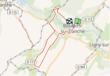
10.7 km | 12.7 km-effort
2h 52min
Yes
Trail On foot Bonnières - BONNIERES (62) - Les éoliennes - Photo
On foot
temmichel

On foot

Easy
Bonnières, Hauts-de-France, Pas-de-Calais, France
15.2 km | 16.9 km-effort
3h 50min
Yes
Trail Walking Blangerval-Blangermont - Blangermont  - Photo
Walking
Jeni Co'lor

Walking

Medium
Blangerval-Blangermont, Hauts-de-France, Pas-de-Calais, France
14.2 km | 16.4 km-effort
3h 21min
Yes
Trail Other activity Frévent - Nord - Pas-de-Calais - Ligne 305 - Saint-Roch - Frévent - Photo
Other activity
mich54

Other activity

Very easy
Frévent, Hauts-de-France, Pas-de-Calais, France
11 km | 12.4 km-effort
5min
No
Trail Walking Frévent - FREVENT  - Photo
Walking
dehemjacques

Walking

Medium
Frévent, Hauts-de-France, Pas-de-Calais, France
27 km | 31 km-effort
6h 42min
Yes
Trail Walking Frévent - Rando Frevent 16 km - Photo
Walking
alainchti62

Walking

Difficult
Frévent, Hauts-de-France, Pas-de-Calais, France
15.9 km | 18.4 km-effort
4h 11min
Yes
Trail Walking Frévent - Frévent (3) 23.5Kms Dén P 319m - Photo
Walking
alain62rando

Walking

Very difficult
Frévent, Hauts-de-France, Pas-de-Calais, France
24 km | 28 km-effort
6h 4min
Yes


Close
My subscriptions