Trail Other activity Frévent - Nord - Pas-de-Calais - Ligne 305 - Saint-Roch - Frévent - Photo

Nord - Pas-de-Calais - Ligne 305 - Saint-Roch - Frévent

 mich54
mich54

User

© OpenStreetMap contributors
Length
Length
11 km
Max alt
Max alt
158 m
Uphill gradient
Uphill gradient
119 m
Km-Effort
Km-Effort  
12.4 km
Min alt
Min alt
75 m
Downhill gradient
Downhill gradient
60 m
Boucle
Boucle
No
Creation date :
2016-11-04 00:00:00.0
Updated on :
2016-11-04 00:00:00.0

(0 Reviews)

Other activity
Other activity
5m
Difficulty : Unknown

Scan this QR Code to open this trail in the SityTrail application

FREE GPS app for hiking

Logo SityTrail SityTrail

IGN / Geographical institutes

Download SityTrail from the App Store Download SityTrail from Google Play

Logo SityTrail SityTrail World

The world is yours!

Download SityTrail from the App Store Download SityTrail from Google Play Download SityTrail on Huawei AppGallery

About

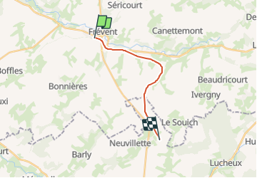
Trail Other activity of 11 km to be discovered at Hauts-de-France, Pas-de-Calais, Frévent. This trail is proposed by mich54.

Description

Section de Bouquemaison à Frévent.
La ligne de Saint-Roch à Frévent est une ligne de chemin de fer non électrifiée à voie unique qui relie la gare de Saint-Roch (Somme) à celle de Frévent sur la ligne de Fives à Abbeville. Elle est déposée sur une partie de son parcours, entre Frévent et Doullens.(Source Wikipédia)

Elevation profile

Positioning

Country:
France
Region :
Hauts-de-France
Department/Province :
Pas-de-Calais
Municipality :
Frévent
Location:
Unknown
Start:(UTM)
449034 ; 5569345 (31U) N.

Trails nearby

Trail Walking Boubers-sur-Canche - 7 km autour de Boubers sur Canche - Photo
Walking
tracegps

Walking

Easy
Boubers-sur-Canche, Hauts-de-France, Pas-de-Calais, France
6.8 km | 7.9 km-effort
1h 40min
Yes
Trail Walking Ligny-sur-Canche - LIGNY SUR CANCHE - Le fond de Boubers - Photo
Walking
temmichel

Walking

Difficult
Ligny-sur-Canche, Hauts-de-France, Pas-de-Calais, France
10.7 km | 12.7 km-effort
2h 52min
Yes
Trail On foot Bonnières - BONNIERES (62) - Les éoliennes - Photo
On foot
temmichel

On foot

Easy
Bonnières, Hauts-de-France, Pas-de-Calais, France
15.2 km | 16.9 km-effort
3h 50min
Yes
Trail Walking Frévent - FREVENT  - Photo
Walking
dehemjacques

Walking

Medium
Frévent, Hauts-de-France, Pas-de-Calais, France
27 km | 31 km-effort
6h 42min
Yes
Trail Walking Frévent - Rando Frevent 16 km - Photo
Walking
alainchti62

Walking

Difficult
Frévent, Hauts-de-France, Pas-de-Calais, France
15.9 km | 18.4 km-effort
4h 11min
Yes
Trail Walking Frévent - Frévent (3) 23.5Kms Dén P 319m - Photo
Walking
alain62rando

Walking

Very difficult
Frévent, Hauts-de-France, Pas-de-Calais, France
24 km | 28 km-effort
6h 4min
Yes


Close
My subscriptions