Trail Cycle Saint-Héand - Pont-Fançais - Photo
 ddx42
ddx42

User

© OpenStreetMap contributors
Length
Length
43 km
Max alt
Max alt
857 m
Uphill gradient
Uphill gradient
748 m
Km-Effort
Km-Effort  
53 km
Min alt
Min alt
472 m
Downhill gradient
Downhill gradient
748 m
Boucle
Boucle
Yes
Creation date :
2014-12-10 00:00:00.0
Updated on :
2014-12-10 00:00:00.0

(0 Reviews)

Cycle
Cycle
2h00
Difficulty : Easy

Scan this QR Code to open this trail in the SityTrail application

FREE GPS app for hiking

Logo SityTrail SityTrail

IGN / Geographical institutes

Download SityTrail from the App Store Download SityTrail from Google Play

Logo SityTrail SityTrail World

The world is yours!

Download SityTrail from the App Store Download SityTrail from Google Play Download SityTrail on Huawei AppGallery

About

Trail Cycle of 43 km to be discovered at Auvergne-Rhône-Alpes, Loire, Saint-Héand. This trail is proposed by ddx42.

Description

Parcours d'entrainement.

Elevation profile

Positioning

Country:
France
Region :
Auvergne-Rhône-Alpes
Department/Province :
Loire
Municipality :
Saint-Héand
Location:
Unknown
Start:(UTM)
606645 ; 5042656 (31T) N.

Trails nearby

Trail Walking Saint-Héand - St Heand, Montrond, Mont Morin, Pierre de la Bauche et retour St Heand - Photo
Walking
acsglaurent

Walking

Medium
(1)
Saint-Héand, Auvergne-Rhône-Alpes, Loire, France
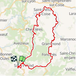
16 km | 23 km-effort
5h 20min
Yes
Trail Walking La Fouillouse - Randonnée au dessus de La Fouillouse  - Photo
Walking
dudu42

Walking

Medium
La Fouillouse, Auvergne-Rhône-Alpes, Loire, France
14.6 km | 19.9 km-effort
3h 39min
Yes
Trail Mountain bike Veauche - Par Monts et par Veauche (2014-VTT-70km) - Veauche - Photo
Mountain bike
tracegps

Mountain bike

Very difficult
Veauche, Auvergne-Rhône-Alpes, Loire, France
69 km | 90 km-effort
6h 0min
Yes
Trail Mountain bike Veauche - Par Monts et par Veauche (2014-VTT-45km) - Veauche - Photo
Mountain bike
tracegps

Mountain bike

Difficult
Veauche, Auvergne-Rhône-Alpes, Loire, France
47 km | 61 km-effort
4h 0min
Yes
Trail Mountain bike L'Étrat - 16ème Randonnée Le Terrassou (2013-VTT-60km) - L'Étrat - Photo
Mountain bike
tracegps

Mountain bike

Very difficult
L'Étrat, Auvergne-Rhône-Alpes, Loire, France
60 km | 84 km-effort
5h 30min
Yes
Trail Walking Saint-Héand - izzy - Photo
Walking
bena42

Walking

Easy
Saint-Héand, Auvergne-Rhône-Alpes, Loire, France
5.9 km | 8.1 km-effort
1h 10min
Yes
Trail Mountain bike Veauche - Par Monts et par Veauche - Veauche - Photo
Mountain bike
tracegps

Mountain bike

Very difficult
Veauche, Auvergne-Rhône-Alpes, Loire, France
69 km | 97 km-effort
6h 0min
Yes
Trail Walking Saint-Héand - tour de st heand - Photo
Walking
acsglaurent

Walking

Very easy
Saint-Héand, Auvergne-Rhône-Alpes, Loire, France
13.2 km | 18.3 km-effort
3h 15min
Yes
Trail Walking Saint-Héand - Saint-héand, la pierre de la bauche, les alisiers, le rivollier, les baraques, Saint-héand - Photo
Walking
nollac

Walking

Medium
Saint-Héand, Auvergne-Rhône-Alpes, Loire, France
12.3 km | 17.8 km-effort
2h 53min
Yes


Close
My subscriptions