Trail Walking Queige - Tour du Beaufortain Etape 1/7 - Photo

Tour du Beaufortain Etape 1/7

© OpenStreetMap contributors
Length
Length
15.2 km
Max alt
Max alt
1728 m
Uphill gradient
Uphill gradient
1321 m
Km-Effort
Km-Effort  
30 km
Min alt
Min alt
593 m
Downhill gradient
Downhill gradient
371 m
Boucle
Boucle
No
Creation date :
2014-12-10 00:00:00.0
Updated on :
2014-12-10 00:00:00.0

(0 Reviews)

Walking
Walking
7h00
Difficulty : Unknown

Scan this QR Code to open this trail in the SityTrail application

FREE GPS app for hiking

Logo SityTrail SityTrail

IGN / Geographical institutes

Download SityTrail from the App Store Download SityTrail from Google Play

Logo SityTrail SityTrail World

The world is yours!

Download SityTrail from the App Store Download SityTrail from Google Play Download SityTrail on Huawei AppGallery

About

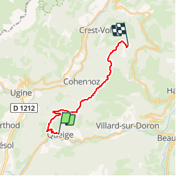
Trail Walking of 15.2 km to be discovered at Auvergne-Rhône-Alpes, Savoy, Queige. This trail is proposed by renaud.levant.

Description

Première étape dur tour (sur sept), de Queige au refuge du Lachat

Elevation profile

Positioning

Country:
France
Region :
Auvergne-Rhône-Alpes
Department/Province :
Savoy
Municipality :
Queige
Location:
Unknown
Start:(UTM)
302191 ; 5066103 (32T) N.

Trails nearby

Trail Walking Queige - Le sentier de la mémoire - Les Pointières - Photo
Walking
tracegps

Walking

Medium
(1)
Queige, Auvergne-Rhône-Alpes, Savoy, France
5.1 km | 8.9 km-effort
3h 0min
Yes
Trail Mountain bike Villard-sur-Doron - devalbertville - Photo
Mountain bike
biollay

Mountain bike

Difficult
(1)
Villard-sur-Doron, Auvergne-Rhône-Alpes, Savoy, France
18.9 km | 27 km-effort
1h 30min
No
Trail Walking Marthod - Santier botanique - Photo
Walking
biollay

Walking

Difficult
Marthod, Auvergne-Rhône-Alpes, Savoy, France
7.3 km | 12 km-effort
2h 49min
Yes
Trail Walking Villard-sur-Doron - Mont Bisanne et Croix de Coste - Photo
Walking
flip38

Walking

Difficult
Villard-sur-Doron, Auvergne-Rhône-Alpes, Savoy, France
22 km | 34 km-effort
6h 34min
Yes
Trail Snowshoes Villard-sur-Doron - De Bisanne 1500 à Mont Bisanne - Photo
Snowshoes
ilur56

Snowshoes

Medium
Villard-sur-Doron, Auvergne-Rhône-Alpes, Savoy, France
8.9 km | 15.2 km-effort
3h 2min
Yes
Trail Snowshoes Queige - Le Haut du Pré depuis le parking des Croix - Photo
Snowshoes
ilur56

Snowshoes

Medium
Queige, Auvergne-Rhône-Alpes, Savoy, France
7.1 km | 14.5 km-effort
2h 42min
Yes
Trail Walking Ugine - chateau - Photo
Walking
Bugeat

Walking

Medium
Ugine, Auvergne-Rhône-Alpes, Savoy, France
15.8 km | 29 km-effort
4h 11min
Yes
Trail Walking Queige - La Roche Pourrie depuis les Chappes - Photo
Walking
tracegps

Walking

Difficult
Queige, Auvergne-Rhône-Alpes, Savoy, France
4.3 km | 10.3 km-effort
3h 4min
Yes
Trail Walking Venthon - Traversée de la Roche Pourrie, Mont Mirantin, 2460m - Photo
Walking
tracegps

Walking

Difficult
Venthon, Auvergne-Rhône-Alpes, Savoy, France
15.4 km | 33 km-effort
9h 30min
Yes


Close
My subscriptions