Trail Walking Husseren-Wesserling - Ht-Mahrel - Photo
 dick68
dick68

User

© OpenStreetMap contributors
Length
Length
10.9 km
Max alt
Max alt
627 m
Uphill gradient
Uphill gradient
307 m
Km-Effort
Km-Effort  
15 km
Min alt
Min alt
439 m
Downhill gradient
Downhill gradient
306 m
Boucle
Boucle
Yes
Creation date :
2014-12-10 00:00:00.0
Updated on :
2014-12-10 00:00:00.0

(0 Reviews)

Walking
Walking
3h15
Difficulty : Easy

Scan this QR Code to open this trail in the SityTrail application

FREE GPS app for hiking

Logo SityTrail SityTrail

IGN / Geographical institutes

Download SityTrail from the App Store Download SityTrail from Google Play

Logo SityTrail SityTrail World

The world is yours!

Download SityTrail from the App Store Download SityTrail from Google Play Download SityTrail on Huawei AppGallery

About

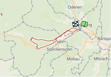
Trail Walking of 10.9 km to be discovered at Grand Est, Haut-Rhin, Husseren-Wesserling. This trail is proposed by dick68.

Description

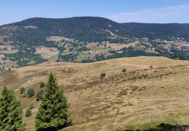
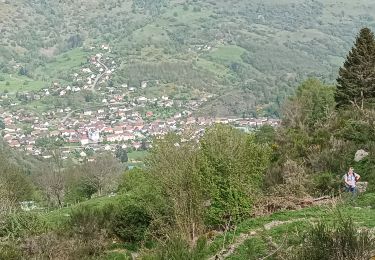
Fellering - Pont_Rouge - Oelberg - Brisgau - Urbes - Mémorial - Mahrel - Ht_Mahrel- Refuge AN - Urbes - Sentier découverte - Pont_Rouge

Elevation profile

Positioning

Country:
France
Region :
Grand Est
Department/Province :
Haut-Rhin
Municipality :
Husseren-Wesserling
Location:
Unknown
Start:(UTM)
349143 ; 5306247 (32T) N.

Trails nearby

Trail Walking Linthal - Markstein - Photo
Walking
VacheKiri67

Walking

Medium
(1)
Linthal, Grand Est, Haut-Rhin, France
14 km | 19.8 km-effort
4h 45min
Yes
Trail Walking Storckensohn - lac des perches marchettes - Photo
Walking
lacote

Walking

Medium
(1)
Storckensohn, Grand Est, Haut-Rhin, France
11.9 km | 20 km-effort
4h 8min
Yes
Trail Walking Fellering - Felsach _chapelle ST Nicolas_frenz - Photo
Walking
Le grand Claude

Walking

Difficult
(1)
Fellering, Grand Est, Haut-Rhin, France
9.6 km | 16.5 km-effort
3h 45min
Yes
Trail Walking Storckensohn - 2022-07-16 Marche Auberge Gazon Vert Chapelle des Ves - Photo
Walking
GUIDE
holtzv

Walking

Very difficult
Storckensohn, Grand Est, Haut-Rhin, France
21 km | 37 km-effort
6h 11min
No
Trail On foot Lautenbachzell - Parking Bellevue - Hundsrucken - Markstein - Photo
On foot
patrickbeyrath

On foot

Medium
(1)
Lautenbachzell, Grand Est, Haut-Rhin, France
9.4 km | 13 km-effort
Unknown
Yes
Trail Walking Oderen - 6146369-Chapelle St Nicolas 2 - Photo
Walking

Walking

Medium
(1)
Oderen, Grand Est, Haut-Rhin, France
10.9 km | 17.9 km-effort
3h 41min
Yes
Trail Walking Oderen - Oderen Bergenbach Langenbach - Photo
Walking
geishouse

Walking

Medium
Oderen, Grand Est, Haut-Rhin, France
7.1 km | 11.6 km-effort
3h 40min
No
Trail Walking Mollau - Le rossberg - Photo
Walking
margotte

Walking

Medium
Mollau, Grand Est, Haut-Rhin, France
14.9 km | 25 km-effort
7h 41min
Yes
Trail Walking Oderen - trek alsacien (1ère étape) - Photo
Walking
Godasses et Grosses Pattes

Walking

Medium
Oderen, Grand Est, Haut-Rhin, France
9.2 km | 18.1 km-effort
4h 0min
No


Close
My subscriptions