Trail Mountain bike Orbey - Tête des Faux - Photo

Tête des Faux

 tracegps
tracegps

User

© OpenStreetMap contributors
Length
Length
14.5 km
Max alt
Max alt
1178 m
Uphill gradient
Uphill gradient
430 m
Km-Effort
Km-Effort  
20 km
Min alt
Min alt
933 m
Downhill gradient
Downhill gradient
430 m
Boucle
Boucle
Yes
Creation date :
2014-12-10 00:00:00.0
Updated on :
2014-12-10 00:00:00.0

(0 Reviews)

Mountain bike
Mountain bike
2h15
Difficulty : Medium

Scan this QR Code to open this trail in the SityTrail application

FREE GPS app for hiking

Logo SityTrail SityTrail

IGN / Geographical institutes

Download SityTrail from the App Store Download SityTrail from Google Play

Logo SityTrail SityTrail World

The world is yours!

Download SityTrail from the App Store Download SityTrail from Google Play Download SityTrail on Huawei AppGallery

About

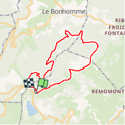
Trail Mountain bike of 14.5 km to be discovered at Grand Est, Haut-Rhin, Orbey. This trail is proposed by tracegps.

Description

Sur ce circuit les éléments intéressants se bousculent. Les points de vue sur la Plaine d'Alsace et la forêt Noire sont très nombreux. Un moment de recueillement vous est proposé au cimetière Duchesne, de nombreux vestiges de la Première Guerre sont visibles tout au long du circuit.

Elevation profile

Photos

Positioning

Country:
France
Region :
Grand Est
Department/Province :
Haut-Rhin
Municipality :
Orbey
Location:
Unknown
Start:(UTM)
358244 ; 5332890 (32U) N.

Trails nearby

Trail Horseback riding Orbey - 2020-06-28 WE Orbey Petit Hohnack Glasborn - Photo
Horseback riding
GUIDE
holtzv

Horseback riding

Difficult
(1)
Orbey, Grand Est, Haut-Rhin, France
22 km | 31 km-effort
4h 5min
Yes
Trail Horseback riding Orbey - 2020-06-27 WE Orbey Noir Gazon Vert Forlet - Photo
Horseback riding
GUIDE
holtzv

Horseback riding

Medium
(1)
Orbey, Grand Est, Haut-Rhin, France
21 km | 30 km-effort
3h 59min
Yes
Trail Other activity Soultzeren - Totom 4 lacs - Photo
Other activity
dinozore

Other activity

Medium
(1)
Soultzeren, Grand Est, Haut-Rhin, France
15.6 km | 26 km-effort
4h 37min
Yes
Trail Walking Orbey - Le Tour du Lac Blanc par le Rocher Hans et le sentier de crête - Photo
Walking
tracegps

Walking

Difficult
(3)
Orbey, Grand Est, Haut-Rhin, France
4.4 km | 7.7 km-effort
2h 30min
Yes
Trail Walking Le Bonhomme - Tête des faux . - Photo
Walking
heurtinpatrick

Walking

Medium
(1)
Le Bonhomme, Grand Est, Haut-Rhin, France
11.9 km | 16.6 km-effort
3h 46min
Yes
Trail Mountain bike Orbey - Lac Blanc  - Têtes des Faux - Photo
Mountain bike
tracegps

Mountain bike

Medium
(1)
Orbey, Grand Est, Haut-Rhin, France
15.3 km | 21 km-effort
1h 0min
Yes
Trail Walking Le Bonhomme - Le Bonhomme - Circuit du village - Photo
Walking
GUIDE
Desrumaux

Walking

Easy
(1)
Le Bonhomme, Grand Est, Haut-Rhin, France
3 km | 5.3 km-effort
1h 30min
Yes
Trail Horseback riding Orbey - gite pre au bois gazon du Faing lac blanc lac noir - Photo
Horseback riding
IsaFal

Horseback riding

Medium
(1)
Orbey, Grand Est, Haut-Rhin, France
17.2 km | 25 km-effort
3h 17min
Yes
Trail Walking Orbey - 2022-07-23 Marche Lacs Blanc Noir Forlet - Photo
Walking
GUIDE
holtzv

Walking

Medium
Orbey, Grand Est, Haut-Rhin, France
16.2 km | 26 km-effort
5h 57min
Yes


Close
My subscriptions