Trail Mountain bike Labaroche - Tour de Labaroche - Photo

Tour de Labaroche

 tracegps
tracegps

User

© OpenStreetMap contributors
Length
Length
23 km
Max alt
Max alt
934 m
Uphill gradient
Uphill gradient
646 m
Km-Effort
Km-Effort  
31 km
Min alt
Min alt
626 m
Downhill gradient
Downhill gradient
642 m
Boucle
Boucle
Yes
Creation date :
2014-12-10 00:00:00.0
Updated on :
2014-12-10 00:00:00.0

(1 Reviews)

Mountain bike
Mountain bike
3h30
Difficulty : Medium

Scan this QR Code to open this trail in the SityTrail application

FREE GPS app for hiking

Logo SityTrail SityTrail

IGN / Geographical institutes

Download SityTrail from the App Store Download SityTrail from Google Play

Logo SityTrail SityTrail World

The world is yours!

Download SityTrail from the App Store Download SityTrail from Google Play Download SityTrail on Huawei AppGallery

About

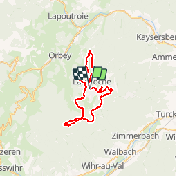
Trail Mountain bike of 23 km to be discovered at Grand Est, Haut-Rhin, Labaroche. This trail is proposed by tracegps.

Description

Circuit autour de Labaroche. Plusieurs vues imprenables sur la plaine d'Alsace. Passage par les jolies ruines du Hohnack. Si vous en avez l'occasion, visitez le musée du Bois de Labaroche.

Elevation profile

Photos

Positioning

Country:
France
Region :
Grand Est
Department/Province :
Haut-Rhin
Municipality :
Labaroche
Location:
Unknown
Start:(UTM)
365460 ; 5329513 (32U) N.

Comments

Please log in to post a review or rate the element


quelques raidillons hard, mais pas long et sinon assez bien panneaute


Trails nearby

Trail Walking Hohrod - Circuit historique 1914-18 Hohrodberg - Linge - Photo
Walking
VacheKiri67

Walking

Medium
(1)
Hohrod, Grand Est, Haut-Rhin, France
14 km | 19.8 km-effort
5h 50min
Yes
Trail Walking Ammerschwihr - Trois Épis le rocher du corbeau  - Photo
Walking
zazie

Walking

Easy
(2)
Ammerschwihr, Grand Est, Haut-Rhin, France
4.4 km | 5.7 km-effort
59min
Yes
Trail Walking Lapoutroie - 2012-06-16 Marche aux Alisiers Orbey - Photo
Walking
GUIDE
holtzv

Walking

Easy
(2)
Lapoutroie, Grand Est, Haut-Rhin, France
11.1 km | 16.6 km-effort
2h 49min
Yes
Trail Horseback riding Gunsbach - Le petit Hohnack - verkort (23) - Photo
Horseback riding
eddyvermeulen1

Horseback riding

Easy
(1)
Gunsbach, Grand Est, Haut-Rhin, France
13.1 km | 18.4 km-effort
2h 25min
Yes
Trail Walking Orbey - Orbey-Labaroche - Photo
Walking
ilur56

Walking

Easy
(1)
Orbey, Grand Est, Haut-Rhin, France
13.7 km | 21 km-effort
4h 17min
Yes
Trail Walking Kaysersberg-Vignoble - Le tour de Kysersberg - Photo
Walking
GUIDE
pascalou73

Walking

Medium
(1)
Kaysersberg-Vignoble, Grand Est, Haut-Rhin, France
7.9 km | 11.7 km-effort
2h 34min
Yes
Trail Walking Hohrod - Hohrodberg - Le Linge - Photo
Walking
sit68000

Walking

Easy
(2)
Hohrod, Grand Est, Haut-Rhin, France
6.5 km | 10.3 km-effort
2h 2min
Yes
Trail Walking Wintzenheim - Château de Pflixbourg depuis Saint Gilles - Photo
Walking
sit68000

Walking

Easy
(1)
Wintzenheim, Grand Est, Haut-Rhin, France
3.7 km | 6.2 km-effort
1h 21min
Yes
Trail On foot Walbach - wihr au val - le petit hohnack - Photo
On foot
OxygenLT

On foot

Medium
(1)
Walbach, Grand Est, Haut-Rhin, France
15.6 km | 25 km-effort
5h 46min
Yes


Close
My subscriptions