Trail Walking Hohrod - Hohrodberg - Le Linge - Photo

Hohrodberg - Le Linge

 sit68000
sit68000

User

© OpenStreetMap contributors
Length
Length
6.5 km
Max alt
Max alt
1048 m
Uphill gradient
Uphill gradient
285 m
Km-Effort
Km-Effort  
10.3 km
Min alt
Min alt
811 m
Downhill gradient
Downhill gradient
290 m
Boucle
Boucle
Yes
Creation date :
2014-12-10 00:00:00.0
Updated on :
2014-12-10 00:00:00.0

(2 Reviews)

Walking
Walking
2h02
Difficulty : Easy

Scan this QR Code to open this trail in the SityTrail application

FREE GPS app for hiking

Logo SityTrail SityTrail

IGN / Geographical institutes

Download SityTrail from the App Store Download SityTrail from Google Play

Logo SityTrail SityTrail World

The world is yours!

Download SityTrail from the App Store Download SityTrail from Google Play Download SityTrail on Huawei AppGallery

About

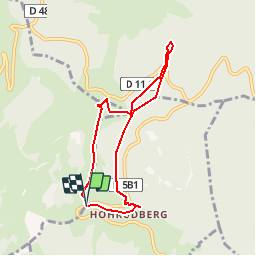
Trail Walking of 6.5 km to be discovered at Grand Est, Haut-Rhin, Hohrod. This trail is proposed by sit68000.

Description

Accès :
Depuis Munster par Hohrod (D5 b1) jusqu'au parking au-dessus de Hohrodberg.
Départ : Face au parking.
Durée : 2h
Distance : 5,8km
Balisage : Circuit historique
Dénivelé : 270m

Prendre le sentier en face du parking. Les n° du parcours correspondent aux bornes explicatives, de 1 à 24.
Carte IGN TOP 25 n°3718

Elevation profile

Positioning

Country:
France
Region :
Grand Est
Department/Province :
Haut-Rhin
Municipality :
Hohrod
Location:
Unknown
Start:(UTM)
360402 ; 5325473 (32U) N.

Comments

Please log in to post a review or rate the element


Trails nearby

Trail Horseback riding Orbey - 2020-06-28 WE Orbey Petit Hohnack Glasborn - Photo
Horseback riding
GUIDE
holtzv

Horseback riding

Difficult
(1)
Orbey, Grand Est, Haut-Rhin, France
22 km | 31 km-effort
4h 5min
Yes
Trail Horseback riding Orbey - 2020-06-27 WE Orbey Noir Gazon Vert Forlet - Photo
Horseback riding
GUIDE
holtzv

Horseback riding

Medium
(1)
Orbey, Grand Est, Haut-Rhin, France
21 km | 30 km-effort
3h 59min
Yes
Trail Other activity Soultzeren - Totom 4 lacs - Photo
Other activity
dinozore

Other activity

Medium
(1)
Soultzeren, Grand Est, Haut-Rhin, France
15.6 km | 26 km-effort
4h 37min
Yes
Trail Walking Munster - De Munster aux 3 Fours (Aller) - Munster - Photo
Walking
tracegps

Walking

Difficult
(1)
Munster, Grand Est, Haut-Rhin, France
14.8 km | 27 km-effort
5h 0min
No
Trail Walking Hohrod - Circuit historique 1914-18 Hohrodberg - Linge - Photo
Walking
VacheKiri67

Walking

Medium
(1)
Hohrod, Grand Est, Haut-Rhin, France
14 km | 19.8 km-effort
5h 50min
Yes
Trail Walking Munster - 19.06.13.Munster  - Photo
Walking
ROPPJP

Walking

Very easy
(1)
Munster, Grand Est, Haut-Rhin, France
7.3 km | 10.6 km-effort
2h 10min
Yes
Trail Walking Soultzeren - Tanet-Gazon du faing par lac vert et retour sommet du Tanet - Photo
Walking
ride-in-Elsass

Walking

Medium
(1)
Soultzeren, Grand Est, Haut-Rhin, France
10 km | 15.6 km-effort
4h 24min
Yes
Trail Mountain bike Labaroche - Tour de Labaroche - Photo
Mountain bike
tracegps

Mountain bike

Medium
(1)
Labaroche, Grand Est, Haut-Rhin, France
23 km | 31 km-effort
3h 30min
Yes
Trail Horseback riding Gunsbach - Le petit Hohnack - verkort (23) - Photo
Horseback riding
eddyvermeulen1

Horseback riding

Easy
(1)
Gunsbach, Grand Est, Haut-Rhin, France
13.1 km | 18.4 km-effort
2h 25min
Yes


Close
My subscriptions