Trail Walking Hohrod - Circuit historique 1914-18 Hohrodberg - Linge - Photo

Circuit historique 1914-18 Hohrodberg - Linge

© OpenStreetMap contributors
Length
Length
14 km
Max alt
Max alt
1048 m
Uphill gradient
Uphill gradient
438 m
Km-Effort
Km-Effort  
19.8 km
Min alt
Min alt
738 m
Downhill gradient
Downhill gradient
441 m
Boucle
Boucle
Yes
Creation date :
2014-12-10 00:00:00.0
Updated on :
2014-12-10 00:00:00.0

(1 Reviews)

Walking
Walking
5h50
Difficulty : Medium

Scan this QR Code to open this trail in the SityTrail application

FREE GPS app for hiking

Logo SityTrail SityTrail

IGN / Geographical institutes

Download SityTrail from the App Store Download SityTrail from Google Play

Logo SityTrail SityTrail World

The world is yours!

Download SityTrail from the App Store Download SityTrail from Google Play Download SityTrail on Huawei AppGallery

About

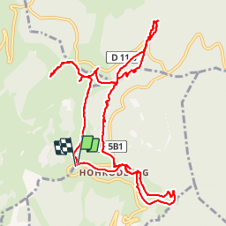
Trail Walking of 14 km to be discovered at Grand Est, Haut-Rhin, Hohrod. This trail is proposed by VacheKiri67.

Description

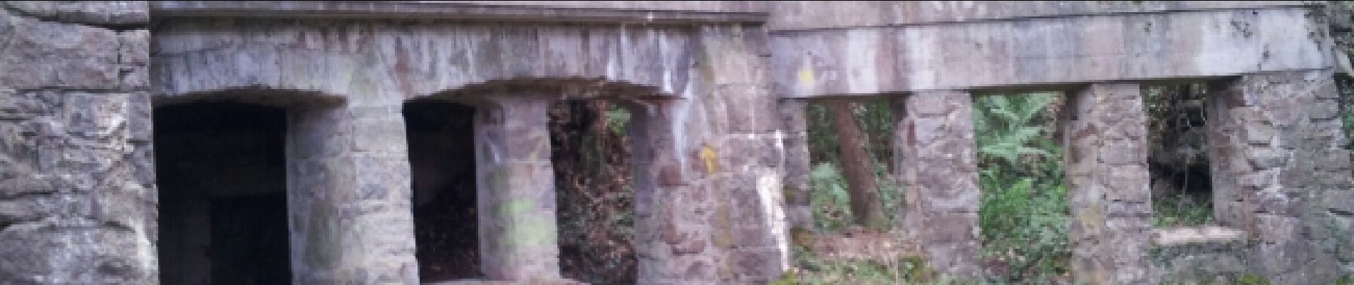
Faite le 15/06/2014 avec notre fils de 9 ans. Circuit historique 1914-18 Hohrodberg - Linge. Le circuit réalisé est le circuit principal (3h) avec les annexes B (champ de bataille du Linge 1h15) et D' (1h15). Nous avons réalisé la boucle autours du Schratzmaennele dans le sens inverse. Descriptif complet à télécharger ici : www.cc-vallee-munster.fr/view_document.php?id=19

Elevation profile

Photos

30 photos in total. Please click on a photo to see them all in the gallery.

Points of interest

Point of interest Hohrod - Point 24 - Photo
VacheKiri67
HOHROD 

Positioning

Country:
France
Region :
Grand Est
Department/Province :
Haut-Rhin
Municipality :
Hohrod
Location:
Unknown
Start:(UTM)
360398 ; 5325474 (32U) N.

Comments

Please log in to post a review or rate the element


Une belle randonnée avec de superbes panoramas. La visite du site historique de la bataille du Linge est à faire absolument.


Trails nearby

Trail Horseback riding Orbey - 2020-06-28 WE Orbey Petit Hohnack Glasborn - Photo
Horseback riding
GUIDE
holtzv

Horseback riding

Difficult
(1)
Orbey, Grand Est, Haut-Rhin, France
22 km | 31 km-effort
4h 5min
Yes
Trail Horseback riding Orbey - 2020-06-27 WE Orbey Noir Gazon Vert Forlet - Photo
Horseback riding
GUIDE
holtzv

Horseback riding

Medium
(1)
Orbey, Grand Est, Haut-Rhin, France
21 km | 30 km-effort
3h 59min
Yes
Trail Other activity Soultzeren - Totom 4 lacs - Photo
Other activity
dinozore

Other activity

Medium
(1)
Soultzeren, Grand Est, Haut-Rhin, France
15.6 km | 26 km-effort
4h 37min
Yes
Trail Walking Munster - De Munster aux 3 Fours (Aller) - Munster - Photo
Walking
tracegps

Walking

Difficult
(1)
Munster, Grand Est, Haut-Rhin, France
14.8 km | 27 km-effort
5h 0min
No
Trail Walking Munster - 19.06.13.Munster  - Photo
Walking
ROPPJP

Walking

Very easy
(1)
Munster, Grand Est, Haut-Rhin, France
7.3 km | 10.6 km-effort
2h 10min
Yes
Trail Walking Soultzeren - Tanet-Gazon du faing par lac vert et retour sommet du Tanet - Photo
Walking
ride-in-Elsass

Walking

Medium
(1)
Soultzeren, Grand Est, Haut-Rhin, France
10 km | 15.6 km-effort
4h 24min
Yes
Trail Mountain bike Labaroche - Tour de Labaroche - Photo
Mountain bike
tracegps

Mountain bike

Medium
(1)
Labaroche, Grand Est, Haut-Rhin, France
23 km | 31 km-effort
3h 30min
Yes
Trail Horseback riding Gunsbach - Le petit Hohnack - verkort (23) - Photo
Horseback riding
eddyvermeulen1

Horseback riding

Easy
(1)
Gunsbach, Grand Est, Haut-Rhin, France
13.1 km | 18.4 km-effort
2h 25min
Yes
Trail Horseback riding Orbey - gite pre au bois gazon du Faing lac blanc lac noir - Photo
Horseback riding
IsaFal

Horseback riding

Medium
(1)
Orbey, Grand Est, Haut-Rhin, France
17.2 km | 25 km-effort
3h 17min
Yes


Close
My subscriptions