Trail Mountain bike Champniers - La Chignolle 50 - Champniers - Photo

La Chignolle 50 - Champniers

 tracegps
tracegps

User

© OpenStreetMap contributors
Length
Length
50 km
Max alt
Max alt
144 m
Uphill gradient
Uphill gradient
775 m
Km-Effort
Km-Effort  
61 km
Min alt
Min alt
32 m
Downhill gradient
Downhill gradient
775 m
Boucle
Boucle
Yes
Creation date :
2014-12-10 00:00:00.0
Updated on :
2014-12-10 00:00:00.0

(0 Reviews)

Mountain bike
Mountain bike
3h00
Difficulty : Difficult

Scan this QR Code to open this trail in the SityTrail application

FREE GPS app for hiking

Logo SityTrail SityTrail

IGN / Geographical institutes

Download SityTrail from the App Store Download SityTrail from Google Play

Logo SityTrail SityTrail World

The world is yours!

Download SityTrail from the App Store Download SityTrail from Google Play Download SityTrail on Huawei AppGallery

About

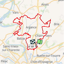
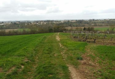
Trail Mountain bike of 50 km to be discovered at New Aquitaine, Charente, Champniers. This trail is proposed by tracegps.

Description

Départ du Décathlon de la zone commerciale, rue de la Genoise pour un parcours de 50 Kilomètres.

Elevation profile

Photos

Positioning

Country:
France
Region :
New Aquitaine
Department/Province :
Charente
Municipality :
Champniers
Location:
Unknown
Start:(UTM)
280845 ; 5063697 (31T) N.

Trails nearby

Trail Walking Angoulême - La Coulée Verte à Angoulème - Photo
Walking
tracegps

Walking

Medium
(1)
Angoulême, New Aquitaine, Charente, France
21 km | 25 km-effort
3h 0min
Yes
Trail Walking Magnac-sur-Touvre - La balade d'Antornac - Photo
Walking
alainjoseph6

Walking

Medium
Magnac-sur-Touvre, New Aquitaine, Charente, France
8.1 km | 9.7 km-effort
3h 50min
No
Trail Walking Angoulême - La rando d'Angoulême entre ville et campagne  - Photo
Walking
alainjoseph6

Walking

Medium
Angoulême, New Aquitaine, Charente, France
8.1 km | 9.9 km-effort
2h 59min
Yes
Trail Walking Champniers - La randonnée sandwich entre la LGV et la RN10 - Photo
Walking
alainjoseph6

Walking

Very easy
Champniers, New Aquitaine, Charente, France
7.7 km | 9.7 km-effort
2h 25min
Yes
Trail Walking Angoulême - La découverte d'Angoulême en partant du parc de Fregneuil  - Photo
Walking
alainjoseph6

Walking

Easy
Angoulême, New Aquitaine, Charente, France
8.9 km | 10.5 km-effort
2h 58min
Yes
Trail Walking Angoulême - De saint Cybard à Fléac - Photo
Walking
alainjoseph6

Walking

Very easy
Angoulême, New Aquitaine, Charente, France
11.4 km | 13.5 km-effort
2h 55min
No
Trail Walking Angoulême - St cybard ==》angoulemz A/R - Photo
Walking
xaliad

Walking

Medium
Angoulême, New Aquitaine, Charente, France
5.6 km | 6.9 km-effort
1h 29min
Yes
Trail Walking Saint-Yrieix-sur-Charente - St iriex - Photo
Walking
rouquie

Walking

Medium
Saint-Yrieix-sur-Charente, New Aquitaine, Charente, France
10.2 km | 11.7 km-effort
2h 31min
Yes
Trail Walking Vindelle - vindelle - Photo
Walking
thierry16

Walking

Medium
Vindelle, New Aquitaine, Charente, France
10.5 km | 11.7 km-effort
2h 27min
Yes


Close
My subscriptions