Trail Walking Champniers - La randonnée sandwich entre la LGV et la RN10 - Photo

La randonnée sandwich entre la LGV et la RN10

© OpenStreetMap contributors
Length
Length
7.7 km
Max alt
Max alt
109 m
Uphill gradient
Uphill gradient
152 m
Km-Effort
Km-Effort  
9.7 km
Min alt
Min alt
40 m
Downhill gradient
Downhill gradient
150 m
Boucle
Boucle
Yes
Creation date :
2019-03-07 14:13:19.625
Updated on :
2019-03-07 17:55:50.133

(0 Reviews)

Walking
Walking
2h25
Difficulty : Very easy

Scan this QR Code to open this trail in the SityTrail application

FREE GPS app for hiking

Logo SityTrail SityTrail

IGN / Geographical institutes

Download SityTrail from the App Store Download SityTrail from Google Play

Logo SityTrail SityTrail World

The world is yours!

Download SityTrail from the App Store Download SityTrail from Google Play Download SityTrail on Huawei AppGallery

About

Trail Walking of 7.7 km to be discovered at New Aquitaine, Charente, Champniers. This trail is proposed by alainjoseph6.

Description

C'est une randonnée surprise, qui fait découvrir une superbe campagne aux portes D'ANGOULÊME.
A faire.

Elevation profile

Photos

Positioning

Country:
France
Region :
New Aquitaine
Department/Province :
Charente
Municipality :
Champniers
Location:
Unknown
Start:(UTM)
280269 ; 5064959 (31T) N.

Trails nearby

Trail Walking Magnac-sur-Touvre - La balade d'Antornac - Photo
Walking
alainjoseph6

Walking

Medium
Magnac-sur-Touvre, New Aquitaine, Charente, France
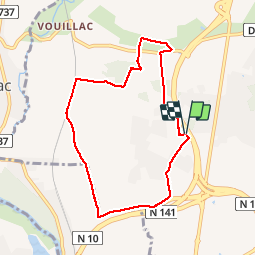
8.1 km | 9.7 km-effort
3h 50min
No
Trail Mountain bike Champniers - La Chignolle 50 - Champniers - Photo
Mountain bike
tracegps

Mountain bike

Difficult
Champniers, New Aquitaine, Charente, France
50 km | 61 km-effort
3h 0min
Yes
Trail Walking Angoulême - St cybard ==》angoulemz A/R - Photo
Walking
xaliad

Walking

Medium
Angoulême, New Aquitaine, Charente, France
5.6 km | 6.9 km-effort
1h 29min
Yes
Trail Walking Saint-Yrieix-sur-Charente - St iriex - Photo
Walking
rouquie

Walking

Medium
Saint-Yrieix-sur-Charente, New Aquitaine, Charente, France
10.2 km | 11.7 km-effort
2h 31min
Yes
Trail Walking Vindelle - vindelle - Photo
Walking
thierry16

Walking

Medium
Vindelle, New Aquitaine, Charente, France
10.5 km | 11.7 km-effort
2h 27min
Yes
Trail Walking Magnac-sur-Touvre - magnac - Photo
Walking
sy!

Walking

Very easy
Magnac-sur-Touvre, New Aquitaine, Charente, France
8.7 km | 10.6 km-effort
2h 0min
Yes
Trail Nordic walking Saint-Yrieix-sur-Charente - fleac boucle2 - Photo
Nordic walking
Ballot.daniel

Nordic walking

Very easy
Saint-Yrieix-sur-Charente, New Aquitaine, Charente, France
5.7 km | 6.5 km-effort
1h 10min
Yes
Trail Nordic walking Saint-Yrieix-sur-Charente - fleac 8 - Photo
Nordic walking
Ballot.daniel

Nordic walking

Easy
Saint-Yrieix-sur-Charente, New Aquitaine, Charente, France
8.3 km | 10.2 km-effort
1h 50min
Yes
Trail Walking Saint-Yrieix-sur-Charente - chauuseloup/Fleac - Photo
Walking
Ballot.daniel

Walking

Very easy
Saint-Yrieix-sur-Charente, New Aquitaine, Charente, France
8.1 km | 9.6 km-effort
2h 0min
Yes


Close
My subscriptions