Trail Walking Arboussols - Retenue de Vinça ->Chapelle Ste Eulària - Photo

Retenue de Vinça ->Chapelle Ste Eulària

 perittel
perittel

User

© OpenStreetMap contributors
Length
Length
17.3 km
Max alt
Max alt
758 m
Uphill gradient
Uphill gradient
660 m
Km-Effort
Km-Effort  
26 km
Min alt
Min alt
253 m
Downhill gradient
Downhill gradient
662 m
Boucle
Boucle
Yes
Creation date :
2014-12-10 00:00:00.0
Updated on :
2014-12-10 00:00:00.0

(0 Reviews)

Walking
Walking
5h26
Difficulty : Medium

Scan this QR Code to open this trail in the SityTrail application

FREE GPS app for hiking

Logo SityTrail SityTrail

IGN / Geographical institutes

Download SityTrail from the App Store Download SityTrail from Google Play

Logo SityTrail SityTrail World

The world is yours!

Download SityTrail from the App Store Download SityTrail from Google Play Download SityTrail on Huawei AppGallery

About

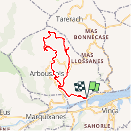
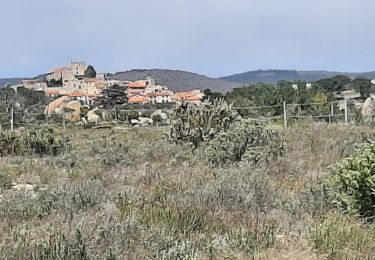
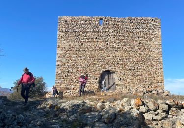
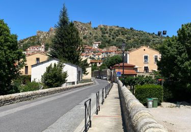
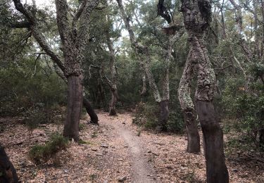
Trail Walking of 17.3 km to be discovered at Occitania, Pyrénées-Orientales, Arboussols. This trail is proposed by perittel.

Description


         Parcours en boucle

Elevation profile

Photos

Points of interest

Point of interest Arboussols - Point 1 - Photo
perittel
ARBOUSSOLS 
Point of interest Arboussols - Point 2 - Photo
perittel
ARBOUSSOLS 
Point of interest Arboussols - Point 3 - Photo
perittel
ARBOUSSOLS 

Positioning

Country:
France
Region :
Occitania
Department/Province :
Pyrénées-Orientales
Municipality :
Arboussols
Location:
Unknown
Start:(UTM)
460098 ; 4722213 (31T) N.

Trails nearby

Trail Mountain bike Vinça - parcours ronde de Sahorle 2013 - Photo
Mountain bike
micleo66

Mountain bike

Medium
(1)
Vinça, Occitania, Pyrénées-Orientales, France
17 km | 22 km-effort
1h 27min
Yes
Trail Walking Montalba-le-Château - Montauban le château corral grandes or - Photo
Walking
66Gribouille83

Walking

Difficult
Montalba-le-Château, Occitania, Pyrénées-Orientales, France
12.9 km | 16.3 km-effort
3h 42min
Yes
Trail Walking Arboussols - Marcevol  - Photo
Walking
francineposkin

Walking

Very difficult
Arboussols, Occitania, Pyrénées-Orientales, France
15.9 km | 23 km-effort
6h 58min
Yes
Trail Walking Tarerach - Tarerach - Photo
Walking
ombrabella

Walking

Difficult
Tarerach, Occitania, Pyrénées-Orientales, France
12 km | 16.2 km-effort
3h 19min
Yes
Trail Walking Los Masos - Los Masos Lionat - Photo
Walking
ombrabella

Walking

Very easy
Los Masos, Occitania, Pyrénées-Orientales, France
11.2 km | 15.5 km-effort
3h 11min
Yes
Trail Walking Montalba-le-Château - montant a - Photo
Walking
66Gribouille83

Walking

Difficult
Montalba-le-Château, Occitania, Pyrénées-Orientales, France
11.8 km | 14.7 km-effort
5h 2min
No
Trail Walking Rodès - 20221222  Rodés - Domanova…. Boucle  - Photo
Walking
ThonyM

Walking

Medium
Rodès, Occitania, Pyrénées-Orientales, France
21 km | 33 km-effort
5h 49min
Yes
Trail Walking Rodès - Gorges de la Guillera - Photo
Walking
Dadou 1

Walking

Easy
Rodès, Occitania, Pyrénées-Orientales, France
3.2 km | 4.9 km-effort
1h 37min
Yes
Trail Walking Rodès - 20220217 au départ de Rodes - Photo
Walking
ThonyM

Walking

Medium
Rodès, Occitania, Pyrénées-Orientales, France
15.2 km | 26 km-effort
4h 56min
Yes


Close
My subscriptions