Trail Other activity Saint-Gingolph - SCA-01-A-St-Gingolph - Villeneuve - Photo

SCA-01-A-St-Gingolph - Villeneuve

 Dgubler
Dgubler

User

© OpenStreetMap contributors
Length
Length
12.4 km
Max alt
Max alt
566 m
Uphill gradient
Uphill gradient
233 m
Km-Effort
Km-Effort  
15.5 km
Min alt
Min alt
370 m
Downhill gradient
Downhill gradient
237 m
Boucle
Boucle
No
Creation date :
2014-12-11 00:00:00.0
Updated on :
2014-12-11 00:00:00.0

(0 Reviews)

Other activity
Other activity
--
Difficulty : Unknown

Scan this QR Code to open this trail in the SityTrail application

FREE GPS app for hiking

Logo SityTrail SityTrail

IGN / Geographical institutes

Download SityTrail from the App Store Download SityTrail from Google Play

Logo SityTrail SityTrail World

The world is yours!

Download SityTrail from the App Store Download SityTrail from Google Play Download SityTrail on Huawei AppGallery

About

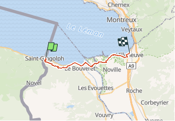
Trail Other activity of 12.4 km to be discovered at Valais/Wallis, Monthey, Saint-Gingolph. This trail is proposed by Dgubler.

Description

C''est le premier tronçon du Sentier culturel des alpes suisses. Nous l''avons parcouru en famille avec Namasha en juillet 2001. Départ au débarcadère de St-Gingolh, arrivée à celui de Villeneuve. Une partie de l''itinéraire peut se faire en bateau CGN entre Le Bouveret et Villeneuve (c''est ce que nous avions fait).

The first leg of the Swiss Alps Cultural Trail, starting at the Steamship Landing of St-Gingolph, through the wildlife reservation of Les Grangettes near Villeneuve

Elevation profile

Positioning

Country:
Switzerland
Region :
Valais/Wallis
Department/Province :
Monthey
Municipality :
Saint-Gingolph
Location:
Unknown
Start:(Dec)
Start:(UTM)
331315 ; 5140086 (32T) N.

Trails nearby

Trail Mountain bike Saint-Gingolph - TransAlpes VTT - 01/25 - St Gingolf - Lac de Tanay - Photo
Mountain bike
tracegps

Mountain bike

Difficult
Saint-Gingolph, Valais/Wallis, Monthey, Switzerland
13.8 km | 27 km-effort
2h 30min
No
Trail Walking Thollon-les-Mémises - 15 juillet - Photo
Walking
Huangdi

Walking

Very easy
Thollon-les-Mémises, Auvergne-Rhône-Alpes, Upper Savoy, France
10.8 km | 26 km-effort
4h 27min
No
Trail Other activity Saint-Gingolph - bdx001_0623 - Photo
Other activity
GUIDE+

Other activity

Very easy
Saint-Gingolph, Valais/Wallis, Monthey, Switzerland
11.3 km | 35 km-effort
8h 5min
No
Trail Other activity Saint-Gingolph - ST_harlin_test - Photo
Other activity
GUIDE+

Other activity

Very easy
Saint-Gingolph, Auvergne-Rhône-Alpes, Upper Savoy, France
32 km | 84 km-effort
14h 44min
No
Trail Other activity Le Léman (VS) - bdr99_StGingolphe_Leysin - Photo
Other activity
GUIDE+

Other activity

Very easy
Le Léman (VS), Valais/Wallis, Monthey, Switzerland
26 km | 38 km-effort
8h 59min
No
Trail Other activity Le Léman (VS) - bdr01_StGingolphe_Trient - Photo
Other activity
GUIDE+

Other activity

Very easy
Le Léman (VS), Valais/Wallis, Monthey, Switzerland
68 km | 170 km-effort
40h 54min
No
Trail Other activity Saint-Gingolph - xxx20_Heremence_StGingolphe - Photo
Other activity
GUIDE+

Other activity

Very easy
Saint-Gingolph, Valais/Wallis, Monthey, Switzerland
59 km | 59 km-effort
13h 24min
No
Trail Walking Novel - Novel -Col de Neuva et Pic Boré - Photo
Walking
marcel.F

Walking

Very difficult
Novel, Auvergne-Rhône-Alpes, Upper Savoy, France
10.3 km | 20 km-effort
4h 37min
Yes
Trail sport Saint-Gingolph - Etape1 St Gingolph-Refuge Chalets de Bise - Photo
sport
anne.legrand

sport

Very easy
Saint-Gingolph, Valais/Wallis, Monthey, Switzerland
11.2 km | 28 km-effort
Unknown
No


Close
My subscriptions