Trail Walking Montgaudry - Montgaudry / Contilly 9,3 Km - Photo

Montgaudry / Contilly 9,3 Km

 ODDAD78
ODDAD78

User

© OpenStreetMap contributors
Length
Length
9.3 km
Max alt
Max alt
206 m
Uphill gradient
Uphill gradient
148 m
Km-Effort
Km-Effort  
11.2 km
Min alt
Min alt
138 m
Downhill gradient
Downhill gradient
147 m
Boucle
Boucle
Yes
Creation date :
2019-04-13 16:36:26.364
Updated on :
2019-04-13 16:36:26.399

(0 Reviews)

Walking
Walking
2h27
Difficulty : Easy

Scan this QR Code to open this trail in the SityTrail application

FREE GPS app for hiking

Logo SityTrail SityTrail

IGN / Geographical institutes

Download SityTrail from the App Store Download SityTrail from Google Play

Logo SityTrail SityTrail World

The world is yours!

Download SityTrail from the App Store Download SityTrail from Google Play Download SityTrail on Huawei AppGallery

About

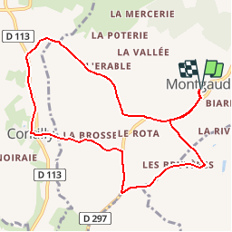
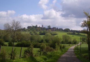
Trail Walking of 9.3 km to be discovered at Normandy, Orne, Montgaudry. This trail is proposed by ODDAD78.

Description

Départ : Eglise de Montgaudry

Elevation profile

Positioning

Country:
France
Region :
Normandy
Department/Province :
Orne
Municipality :
Montgaudry
Location:
Unknown
Start:(UTM)
307734 ; 5364753 (31U) N.

Trails nearby

Trail Walking Belforêt-en-Perche - La Perrière, forêt et village - Photo
Walking
jeannine grandjean

Walking

Difficult
Belforêt-en-Perche, Normandy, Orne, France
11.1 km | 13.8 km-effort
3h 8min
Yes
Trail Walking Pervenchères - [Itinéraire] Le chêne de La Lambonnière - Photo
Walking
ODDAD78

Walking

Medium
(1)
Pervenchères, Normandy, Orne, France
8.7 km | 9.8 km-effort
2h 14min
Yes
Trail Walking Belforêt-en-Perche - le chêne de l'école - Photo
Walking
fournieralain

Walking

Very easy
Belforêt-en-Perche, Normandy, Orne, France
15.7 km | 19.7 km-effort
6h 47min
Yes
Trail Walking Belforêt-en-Perche -  La Perrière - Saint-Germain-de-la-Coudre via Bellême (TCP) 28 km - Photo
Walking

Walking

Medium
Belforêt-en-Perche, Normandy, Orne, France
28 km | 35 km-effort
7h 16min
No
Trail Walking Belforêt-en-Perche - La Perrière - Saint-Germain-de-la-Coudre via Igé (TCP) 27 km - Photo
Walking

Walking

Easy
Belforêt-en-Perche, Normandy, Orne, France
27 km | 33 km-effort
7h 2min
No
Trail Walking Belforêt-en-Perche - La Perrière - Mortagne-au-Perche (TCP) 29 km - Photo
Walking

Walking

Difficult
Belforêt-en-Perche, Normandy, Orne, France
29 km | 34 km-effort
7h 18min
No
Trail Walking Belforêt-en-Perche - La Perrière : village millénaire - Photo
Walking
tracegps

Walking

Medium
Belforêt-en-Perche, Normandy, Orne, France
11.1 km | 14 km-effort
3h 0min
Yes
Trail Walking Belforêt-en-Perche - la perrière par la forêt  - Photo
Walking
Krissray

Walking

Medium
Belforêt-en-Perche, Normandy, Orne, France
5.6 km | 7.6 km-effort
1h 45min
Yes
Trail Walking Belforêt-en-Perche - fourneaux gr jusqu'au ruisseau - Photo
Walking
Krissray

Walking

Medium
Belforêt-en-Perche, Normandy, Orne, France
5 km | 6.7 km-effort
1h 15min
Yes


Close
My subscriptions