Trail Walking Champdeniers - Champeaux - Photo
 olaze
olaze

User

© OpenStreetMap contributors
Length
Length
8.1 km
Max alt
Max alt
152 m
Uphill gradient
Uphill gradient
132 m
Km-Effort
Km-Effort  
9.8 km
Min alt
Min alt
80 m
Downhill gradient
Downhill gradient
133 m
Boucle
Boucle
Yes
Creation date :
2014-12-10 00:00:00.0
Updated on :
2014-12-10 00:00:00.0

(0 Reviews)

Walking
Walking
2h08
Difficulty : Easy

Scan this QR Code to open this trail in the SityTrail application

FREE GPS app for hiking

Logo SityTrail SityTrail

IGN / Geographical institutes

Download SityTrail from the App Store Download SityTrail from Google Play

Logo SityTrail SityTrail World

The world is yours!

Download SityTrail from the App Store Download SityTrail from Google Play Download SityTrail on Huawei AppGallery

About

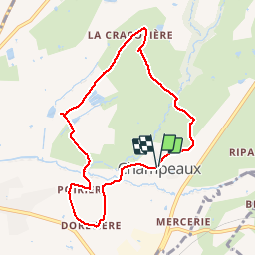
Trail Walking of 8.1 km to be discovered at New Aquitaine, Deux-Sèvres, Champdeniers. This trail is proposed by olaze.

Description

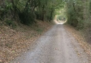
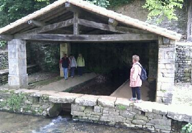
Agréable promenade autour de Champeaux. Valloné.
Club rando ATSCAF79 2013
         

Elevation profile

Photos

Positioning

Country:
France
Region :
New Aquitaine
Department/Province :
Deux-Sèvres
Municipality :
Champdeniers
Location:
Unknown
Start:(UTM)
702394 ; 5151176 (30T) N.

Trails nearby

Trail Horseback riding Augé - Bois Aigu Clavé 2 - Photo
Horseback riding
Dom4i

Horseback riding

Very difficult
(1)
Augé, New Aquitaine, Deux-Sèvres, France
40 km | 50 km-effort
6h 32min
Yes
Trail Walking Germond-Rouvre - 2020-09-19  - Photo
Walking
cagouille79

Walking

Medium
Germond-Rouvre, New Aquitaine, Deux-Sèvres, France
12.9 km | 16.2 km-effort
2h 59min
Yes
Trail Walking Saint-Christophe-sur-Roc - St Christophe sur Roc - Photo
Walking
olaze

Walking

Easy
Saint-Christophe-sur-Roc, New Aquitaine, Deux-Sèvres, France
10.9 km | 13 km-effort
2h 49min
Yes
Trail Walking Mazières-en-Gâtine - Mazières-en-Gâtine Golf - Photo
Walking
Philippe Baraton

Walking

Very easy
Mazières-en-Gâtine, New Aquitaine, Deux-Sèvres, France
9.4 km | 10.9 km-effort
2h 10min
Yes
Trail Walking Germond-Rouvre - azzz - Photo
Walking
Carlosenrique

Walking

Very easy
Germond-Rouvre, New Aquitaine, Deux-Sèvres, France
6.9 km | 8.2 km-effort
1h 40min
Yes
Trail Horseback riding Augé - Bois Aigu Flaye version à revoir  - Photo
Horseback riding
Dom4i

Horseback riding

Very difficult
Augé, New Aquitaine, Deux-Sèvres, France
37 km | 43 km-effort
6h 16min
No
Trail Horseback riding Augé - Bois Aigu v2 - Photo
Horseback riding
Dom4i

Horseback riding

Difficult
Augé, New Aquitaine, Deux-Sèvres, France
30 km | 36 km-effort
4h 42min
Yes
Trail Horseback riding Champdeniers - Rando de l' Autize 27 - Photo
Horseback riding
Dom4i

Horseback riding

Difficult
(1)
Champdeniers, New Aquitaine, Deux-Sèvres, France
28 km | 33 km-effort
4h 22min
Yes
Trail Horseback riding Germond-Rouvre - Rando de l'Autize - Photo
Horseback riding
Dom4i

Horseback riding

Difficult
Germond-Rouvre, New Aquitaine, Deux-Sèvres, France
27 km | 32 km-effort
4h 9min
Yes


Close
My subscriptions