Trail On foot Eguisheim - Abbaye de Marbach vers Col de Marbach - Osenbuhr - Langenberg et retour - Photo

Abbaye de Marbach vers Col de Marbach - Osenbuhr - Langenberg et retour

© OpenStreetMap contributors
Length
Length
11.8 km
Max alt
Max alt
754 m
Uphill gradient
Uphill gradient
482 m
Km-Effort
Km-Effort  
18.3 km
Min alt
Min alt
352 m
Downhill gradient
Downhill gradient
481 m
Boucle
Boucle
Yes
Creation date :
2019-01-10 08:38:05.82
Updated on :
2019-01-23 11:30:07.685

(0 Reviews)

On foot
On foot
--
Difficulty : Medium

Scan this QR Code to open this trail in the SityTrail application

FREE GPS app for hiking

Logo SityTrail SityTrail

IGN / Geographical institutes

Download SityTrail from the App Store Download SityTrail from Google Play

Logo SityTrail SityTrail World

The world is yours!

Download SityTrail from the App Store Download SityTrail from Google Play Download SityTrail on Huawei AppGallery

About

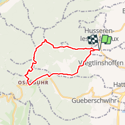
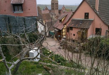
Trail On foot of 11.8 km to be discovered at Grand Est, Haut-Rhin, Eguisheim. This trail is proposed by patrickbeyrath.

Description

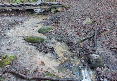
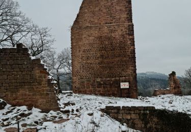
Parking au bord de la D1 au panneau Abbaye de Marbach -prendre triangle jaune direction Col de Marbach puis rond rouge jusqu'à Osenbuhr, Auberge des Chasseurs et repartir circulaire bleu du parcours sportif puis chevalet jaune puis losange rouge direction Langenberg et rester losange rouge jusqu'à l'Abbaye Marbach et retour parking

Elevation profile

Positioning

Country:
France
Region :
Grand Est
Department/Province :
Haut-Rhin
Municipality :
Eguisheim
Location:
Unknown
Start:(UTM)
371845 ; 5320645 (32U) N.

Trails nearby

Trail Walking Wettolsheim - 4 châteaux Wettolsheim Husseren - Photo
Walking
apa

Walking

Medium
(1)
Wettolsheim, Grand Est, Haut-Rhin, France
11.7 km | 17.7 km-effort
4h 28min
No
Trail Walking Osenbach - Osenbach - Sentier des Sols - Photo
Walking
gscheven

Walking

Easy
(1)
Osenbach, Grand Est, Haut-Rhin, France
4.7 km | 6.6 km-effort
3h 0min
Yes
Trail Walking Eguisheim - suuntoapp-Hiking-2023-12-29T09-05-16Z - Photo
Walking
GUIDE
holtzv

Walking

Medium
Eguisheim, Grand Est, Haut-Rhin, France
22 km | 32 km-effort
7h 16min
Yes
Trail Walking Pfaffenheim - Schauenberg 1 - Photo
Walking
regisbodilis

Walking

Easy
(1)
Pfaffenheim, Grand Est, Haut-Rhin, France
10.3 km | 16.5 km-effort
3h 30min
Yes
Trail On foot Walbach - wihr au val - le petit hohnack - Photo
On foot
OxygenLT

On foot

Medium
(1)
Walbach, Grand Est, Haut-Rhin, France
15.6 km | 25 km-effort
5h 46min
Yes
Trail Walking Husseren-les-Châteaux - Husseren les Châteaux - Photo
Walking
oscar1

Walking

Easy
Husseren-les-Châteaux, Grand Est, Haut-Rhin, France
12.7 km | 19.1 km-effort
3h 24min
Yes
Trail Walking Gueberschwihr - Les Marcheurs...et la fondue..26/01/2024 - Photo
Walking
boubou68

Walking

Medium
Gueberschwihr, Grand Est, Haut-Rhin, France
20 km | 31 km-effort
4h 59min
Yes
Trail Walking Eguisheim - Rando des cinq châteaux  - Photo
Walking
Koralie Werny

Walking

Medium
Eguisheim, Grand Est, Haut-Rhin, France
18.4 km | 28 km-effort
5h 19min
Yes
Trail Walking Gueberschwihr - Promenade circulaire Kuckuckstei - Photo
Walking
stef250

Walking

Medium
Gueberschwihr, Grand Est, Haut-Rhin, France
7 km | 10.5 km-effort
2h 57min
Yes


Close
My subscriptions