Trail Snowshoes Eyne - Boucle de la Cambre d'Ase - Photo

Boucle de la Cambre d'Ase

 ilur56
ilur56

User

© OpenStreetMap contributors
Length
Length
13.1 km
Max alt
Max alt
2060 m
Uphill gradient
Uphill gradient
507 m
Km-Effort
Km-Effort  
19.7 km
Min alt
Min alt
1638 m
Downhill gradient
Downhill gradient
473 m
Boucle
Boucle
No
Creation date :
2019-02-20 08:41:38.15
Updated on :
2019-02-20 08:43:36.678

(0 Reviews)

Snowshoes
Snowshoes
--
Difficulty : Easy

Scan this QR Code to open this trail in the SityTrail application

FREE GPS app for hiking

Logo SityTrail SityTrail

IGN / Geographical institutes

Download SityTrail from the App Store Download SityTrail from Google Play

Logo SityTrail SityTrail World

The world is yours!

Download SityTrail from the App Store Download SityTrail from Google Play Download SityTrail on Huawei AppGallery

About

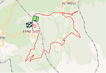
Trail Snowshoes of 13.1 km to be discovered at Occitania, Pyrénées-Orientales, Eyne. This trail is proposed by ilur56.

Description

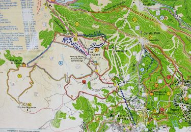
Boucle autour des stations de ski d'Eyne et de Saint Pierre des Forcats avec de nombreuses traversées de pistes

Elevation profile

Positioning

Country:
France
Region :
Occitania
Department/Province :
Pyrénées-Orientales
Municipality :
Eyne
Location:
Unknown
Start:(UTM)
426027 ; 4703348 (31T) N.

Trails nearby

Trail Walking Eyne - Eyne,col de Nuria,pic d'Eyne,Torre d'Eyne,Eyne. - Photo
Walking
Machaon6

Walking

Very difficult
(1)
Eyne, Occitania, Pyrénées-Orientales, France
24 km | 43 km-effort
8h 44min
Yes
Trail Walking Planès - étang de Planès - Photo
Walking
fhascoet

Walking

Medium
(2)
Planès, Occitania, Pyrénées-Orientales, France
10.8 km | 19.6 km-effort
3h 54min
No
Trail Walking Eyne - Le Cambre d'Ase - Photo
Walking
tracegps

Walking

Difficult
(1)
Eyne, Occitania, Pyrénées-Orientales, France
8.9 km | 22 km-effort
4h 0min
Yes
Trail Mountain bike Font-Romeu-Odeillo-Via - Espace VTT FFC Pyrénées Catalanes - Circuit n° 6 - Forêt d'Egat - Photo
Mountain bike
tracegps

Mountain bike

Medium
(2)
Font-Romeu-Odeillo-Via, Occitania, Pyrénées-Orientales, France
7.6 km | 10.1 km-effort
1h 0min
Yes
Trail Walking Eyne - Vallée d'Eyne - Photo
Walking
GUIDE
nadinebondoux

Walking

Medium
Eyne, Occitania, Pyrénées-Orientales, France
10.7 km | 17.6 km-effort
4h 40min
Yes
Trail Walking Bolquère - bolqueres - Photo
Walking
foxtay

Walking

Very easy
(1)
Bolquère, Occitania, Pyrénées-Orientales, France
3.8 km | 4.6 km-effort
1h 1min
Yes
Trail Walking Saint-Pierre-dels-Forcats - bains  de St Thomas  - Photo
Walking
Ptitjack30

Walking

Medium
(1)
Saint-Pierre-dels-Forcats, Occitania, Pyrénées-Orientales, France
8.6 km | 12.2 km-effort
2h 42min
No
Trail Walking Eyne - eyne - Photo
Walking
gardelg

Walking

Medium
(2)
Eyne, Occitania, Pyrénées-Orientales, France
6.2 km | 8.2 km-effort
2h 1min
Yes
Trail Walking Eyne - La vallée d'Eyne - Photo
Walking
suresnois

Walking

Difficult
Eyne, Occitania, Pyrénées-Orientales, France
11.2 km | 18 km-effort
7h 8min
Yes


Close
My subscriptions