Trail Cycle Ferrette - 0110  2  Ferette - Cornol - Photo

0110 2 Ferette - Cornol

 LCGsell
LCGsell

User

© OpenStreetMap contributors
Length
Length
23 km
Max alt
Max alt
601 m
Uphill gradient
Uphill gradient
395 m
Km-Effort
Km-Effort  
28 km
Min alt
Min alt
445 m
Downhill gradient
Downhill gradient
374 m
Boucle
Boucle
No
Creation date :
2014-12-11 00:00:00.0
Updated on :
2014-12-11 00:00:00.0

(0 Reviews)

Cycle
Cycle
--
Difficulty : Unknown

Scan this QR Code to open this trail in the SityTrail application

FREE GPS app for hiking

Logo SityTrail SityTrail

IGN / Geographical institutes

Download SityTrail from the App Store Download SityTrail from Google Play

Logo SityTrail SityTrail World

The world is yours!

Download SityTrail from the App Store Download SityTrail from Google Play Download SityTrail on Huawei AppGallery

About

Trail Cycle of 23 km to be discovered at Grand Est, Haut-Rhin, Ferrette. This trail is proposed by LCGsell.

Description

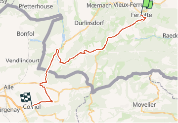
Von Ferette fahren wir über den Berg auf der D41 nach Winkel das wir in einer Baumallee erreichen. Ausgangs Dorf biegt die D41 nach rechts ab und über einen steilen Hügel geht es nach Oberlarg und nach Levincourt hinunter. In Levincourt halten wir nach rechts / Norden nach Courtavon. Hier biegen wir im beinahe 180 Grad Winkel nach links in die uns bereits bekannte D473 ein. Ein Badesee, rechts von uns, wird passiert und wir sind bald an der französich-schweizerischen Grenze. In eine leichten Abfahrt erreichen wir Miécourt und die sanfte Landschaft des Pountruter Zipfels liegt vor uns. Miécourt durchqueren wir über seine Breitseite und halten auf dem mystischen Mont Terri, Jurahügel zu an dessen Fuss Cornol liegt und durch welchen sich die Autobahn durchbohrt. In Cornol stossen wir auf die Nationale Veloroute Nr. 7, die Jura Route.

We exit Ferette to the top of the hill on road D41 and over the soft crest we finally downhill towards Winkel which we enter trough an alley. In Winkel we turn right and at the Y we cycle right / west , still on D41 across a steep hill to Oberlarg and down to Levincourt. Stay right / north in Levincourt to Courtavon. Here we turn almost 180 degrees left entering D473. We pass a swimming pond and camp ground which is to our right and across open fields we pass the border back to Switzerland and after an easy downhill reach Miécourt and the gentle landscape of the Swiss „lap“ of Porrentruy lays before us. We pass Miécourt across its wide side and head south towards the mystic Mount Terri , jura hill. At its foot lays Cornol and nearby the highway grinds its tunnel through the hill. In Cornol we hit on National Bike Route Nr.7, the Jura Route.

Elevation profile

Positioning

Country:
France
Region :
Grand Est
Department/Province :
Haut-Rhin
Municipality :
Ferrette
Location:
Unknown
Start:(UTM)
373006 ; 5261482 (32T) N.

Trails nearby

Trail Walking Ferrette - Ferrette - Grotte des nains - Photo
Walking
regisbodilis

Walking

Easy
(1)
Ferrette, Grand Est, Haut-Rhin, France
13.1 km | 21 km-effort
4h 0min
Yes
Trail Walking Kœstlach - Rando Koestlach...
Walking
boubou68

Walking

Very difficult
Kœstlach, Grand Est, Haut-Rhin, France
22 km | 31 km-effort
6h 43min
Yes
Trail Walking Ferrette - Ferrette ,château, grotte des nains,rossberg - Photo
Walking
jcguew

Walking

Difficult
Ferrette, Grand Est, Haut-Rhin, France
8.6 km | 13.7 km-effort
5h 1min
Yes
Trail Walking Lutter - rdpr 20200929 lutter - Photo
Walking
GUIDE
stempfel52

Walking

Difficult
Lutter, Grand Est, Haut-Rhin, France
15.8 km | 23 km-effort
4h 52min
Yes
Trail Equestrian Bouxwiller - Bouxwiller Doubs Franche Montagne - Photo
Equestrian
meggstone

Equestrian

Difficult
(1)
Bouxwiller, Grand Est, Haut-Rhin, France
104 km | 146 km-effort
18h 22min
No
Trail Cycle Ferrette - La balade des étangs -  Ferrette - Photo
Cycle
tracegps

Cycle

Difficult
Ferrette, Grand Est, Haut-Rhin, France
59 km | 68 km-effort
3h 0min
Yes
Trail Walking Ferrette - Ferrette château et grotte des nains - Photo
Walking
juliengsell

Walking

Medium
Ferrette, Grand Est, Haut-Rhin, France
6 km | 9 km-effort
2h 21min
Yes
Trail Road bike Ferrette - Lucelle - Photo
Road bike
PhilippeC54

Road bike

Medium
Ferrette, Grand Est, Haut-Rhin, France
53 km | 66 km-effort
3h 10min
Yes
Trail Walking Ferrette - Ferrette Chalet de Koestlach au Kastelberg - Photo
Walking
domi68440

Walking

Medium
Ferrette, Grand Est, Haut-Rhin, France
14.2 km | 20 km-effort
4h 45min
Yes


Close
My subscriptions