Trail Walking Uffholtz - Molkenrain 1 - Photo
© OpenStreetMap contributors
Length
Length
15.4 km
Max alt
Max alt
1043 m
Uphill gradient
Uphill gradient
772 m
Km-Effort
Km-Effort  
26 km
Min alt
Min alt
303 m
Downhill gradient
Downhill gradient
773 m
Boucle
Boucle
Yes
Creation date :
2014-12-10 00:00:00.0
Updated on :
2014-12-10 00:00:00.0

(1 Reviews)

Walking
Walking
4h00
Difficulty : Difficult

Scan this QR Code to open this trail in the SityTrail application

FREE GPS app for hiking

Logo SityTrail SityTrail

IGN / Geographical institutes

Download SityTrail from the App Store Download SityTrail from Google Play

Logo SityTrail SityTrail World

The world is yours!

Download SityTrail from the App Store Download SityTrail from Google Play Download SityTrail on Huawei AppGallery

About

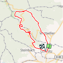
Trail Walking of 15.4 km to be discovered at Grand Est, Haut-Rhin, Uffholtz. This trail is proposed by regisbodilis.

Description

Uffoltz - Chateau d'Herrenfluh - Molkenrain - chateau d'Hirzenstein - Wattwiller - Uffoltz

Elevation profile

Positioning

Country:
France
Region :
Grand Est
Department/Province :
Haut-Rhin
Municipality :
Uffholtz
Location:
Unknown
Start:(UTM)
363638 ; 5297879 (32T) N.

Comments

Please log in to post a review or rate the element


Trails nearby

Trail Walking Soultz-Haut-Rhin - Hartmannswillerkopf - Circuit découverte - Photo
Walking
VacheKiri67

Walking

Easy
(1)
Soultz-Haut-Rhin, Grand Est, Haut-Rhin, France
3.6 km | 5.2 km-effort
1h 46min
Yes
Trail Walking Soultz-Haut-Rhin - Hartmannswillerkopf - Circuit anneau bleu - Photo
Walking
VacheKiri67

Walking

Medium
(1)
Soultz-Haut-Rhin, Grand Est, Haut-Rhin, France
3.7 km | 5.9 km-effort
1h 37min
Yes
Trail Other activity Steinbach - lac du ballon - Photo
Other activity
rodabruna

Other activity

Very easy
(1)
Steinbach, Grand Est, Haut-Rhin, France
33 km | 64 km-effort
5h 1min
No
Trail Trail Wattwiller - The History Ultra - stage 1 - Photo
Trail
Olivier Houette

Trail

Very easy
(1)
Wattwiller, Grand Est, Haut-Rhin, France
28 km | 48 km-effort
Unknown
No
Trail Walking Steinbach - Rando CLAS du 02/11/2023 - Photo
Walking
boubou68

Walking

Very difficult
Steinbach, Grand Est, Haut-Rhin, France
17.7 km | 27 km-effort
4h 35min
Yes
Trail Walking Steinbach - Rando Marcheurs du 03/07/2023 par ALAIN - Photo
Walking
boubou68

Walking

Very difficult
Steinbach, Grand Est, Haut-Rhin, France
20 km | 34 km-effort
5h 1min
Yes
Trail Walking Wattwiller - Wattwiller - Domaine du Hirtz (30/03/2023) - Photo
Walking
Richard68500

Walking

Easy
Wattwiller, Grand Est, Haut-Rhin, France
6.1 km | 9.9 km-effort
2h 7min
Yes
Trail Road bike Cernay - Le Grand ballon de Cernay  - Photo
Road bike
nadd73

Road bike

Difficult
Cernay, Grand Est, Haut-Rhin, France
23 km | 36 km-effort
2h 15min
No
Trail Walking Uffholtz - Uffholtz - Wattwiller (23/12/2021) - Photo
Walking
Richard68500

Walking

Medium
Uffholtz, Grand Est, Haut-Rhin, France
11.4 km | 17.2 km-effort
3h 27min
Yes


Close
My subscriptions