Trail Walking Steinbach - Rando CLAS du 02/11/2023 - Photo

Rando CLAS du 02/11/2023

 boubou68
boubou68

User

© OpenStreetMap contributors
Length
Length
17.7 km
Max alt
Max alt
917 m
Uphill gradient
Uphill gradient
697 m
Km-Effort
Km-Effort  
27 km
Min alt
Min alt
327 m
Downhill gradient
Downhill gradient
697 m
Boucle
Boucle
Yes
Creation date :
2023-11-02 08:05:05.046
Updated on :
2023-11-02 14:21:26.379

(0 Reviews)

Walking
Walking
4h35
Difficulty : Very difficult

Scan this QR Code to open this trail in the SityTrail application

FREE GPS app for hiking

Logo SityTrail SityTrail

IGN / Geographical institutes

Download SityTrail from the App Store Download SityTrail from Google Play

Logo SityTrail SityTrail World

The world is yours!

Download SityTrail from the App Store Download SityTrail from Google Play Download SityTrail on Huawei AppGallery

About

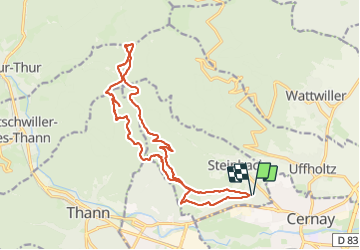
Trail Walking of 17.7 km to be discovered at Grand Est, Haut-Rhin, Steinbach. This trail is proposed by boubou68.

Description

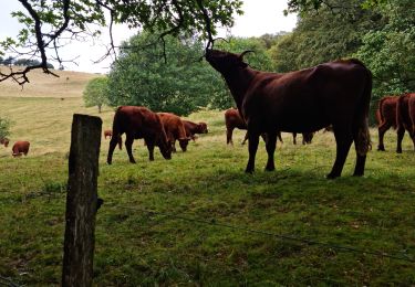
Rando bien pluvieuse en matinée " les gentils canards" qui m'ont accompagné  étaient ravis de se retrouver.!!
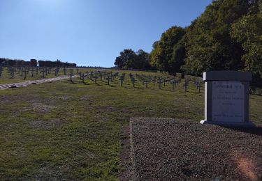
Abri Becherkopf plein à notre arrivée...nous avons déjeuné au grand air..
Plus de pluie l'après midi...
Le vent pratiquement absent.
Un grand merci à les compagnons de route.

Elevation profile

Photos

Positioning

Country:
France
Region :
Grand Est
Department/Province :
Haut-Rhin
Municipality :
Steinbach
Location:
Unknown
Start:(UTM)
362176 ; 5297298 (32T) N.

Trails nearby

Trail Walking Soultz-Haut-Rhin - Hartmannswillerkopf - Circuit découverte - Photo
Walking
VacheKiri67

Walking

Easy
(1)
Soultz-Haut-Rhin, Grand Est, Haut-Rhin, France
3.6 km | 5.2 km-effort
1h 46min
Yes
Trail Walking Soultz-Haut-Rhin - Hartmannswillerkopf - Circuit anneau bleu - Photo
Walking
VacheKiri67

Walking

Medium
(1)
Soultz-Haut-Rhin, Grand Est, Haut-Rhin, France
3.7 km | 5.9 km-effort
1h 37min
Yes
Trail Other activity Steinbach - lac du ballon - Photo
Other activity
rodabruna

Other activity

Very easy
(1)
Steinbach, Grand Est, Haut-Rhin, France
33 km | 64 km-effort
5h 1min
No
Trail Trail Wattwiller - The History Ultra - stage 1 - Photo
Trail
Olivier Houette

Trail

Very easy
(1)
Wattwiller, Grand Est, Haut-Rhin, France
28 km | 48 km-effort
Unknown
No
Trail Walking Thann - SityTrail - 2489713 - thann-roche--albert--grumbachkopf - Photo
Walking
argonneuweg

Walking

Medium
(1)
Thann, Grand Est, Haut-Rhin, France
7.6 km | 12 km-effort
2h 28min
Yes
Trail Walking Uffholtz - Molkenrain 1 - Photo
Walking
regisbodilis

Walking

Difficult
(1)
Uffholtz, Grand Est, Haut-Rhin, France
15.4 km | 26 km-effort
4h 0min
Yes
Trail Walking Steinbach - Rando Marcheurs du 03/07/2023 par ALAIN - Photo
Walking
boubou68

Walking

Very difficult
Steinbach, Grand Est, Haut-Rhin, France
20 km | 34 km-effort
5h 1min
Yes
Trail Walking Wattwiller - Wattwiller - Domaine du Hirtz (30/03/2023) - Photo
Walking
Richard68500

Walking

Easy
Wattwiller, Grand Est, Haut-Rhin, France
6.1 km | 9.9 km-effort
2h 7min
Yes
Trail Road bike Cernay - Le Grand ballon de Cernay  - Photo
Road bike
nadd73

Road bike

Difficult
Cernay, Grand Est, Haut-Rhin, France
23 km | 36 km-effort
2h 15min
No


Close
My subscriptions