Trail Walking Vars - col du cracher.pointe de l eyssina - Photo

col du cracher.pointe de l eyssina

 gibello
gibello

User

© OpenStreetMap contributors
Length
Length
8.8 km
Boucle
Boucle
Yes
Creation date :
2019-07-23 07:07:22.204
Updated on :
2019-07-23 14:03:45.145

(0 Reviews)

Walking
Walking
4h32
Difficulty : Medium

Scan this QR Code to open this trail in the SityTrail application

FREE GPS app for hiking

Logo SityTrail SityTrail

IGN / Geographical institutes

Download SityTrail from the App Store Download SityTrail from Google Play

Logo SityTrail SityTrail World

The world is yours!

Download SityTrail from the App Store Download SityTrail from Google Play Download SityTrail on Huawei AppGallery

About

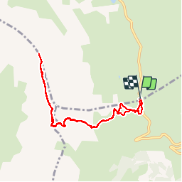
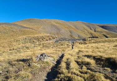
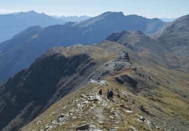
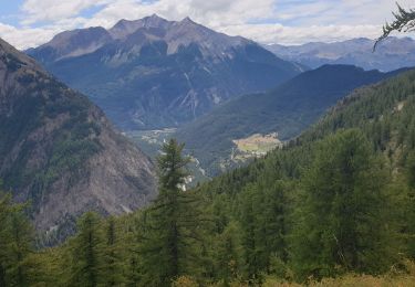
Trail Walking of 8.8 km to be discovered at Provence-Alpes-Côte d'Azur, Hautes-Alpes, Vars. This trail is proposed by gibello.

Description

départ du col de Vars 05
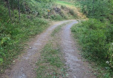
itinéraire au départ compliqué ..

Elevation profile

Photos

Positioning

Country:
France
Region :
Provence-Alpes-Côte d'Azur
Department/Province :
Hautes-Alpes
Municipality :
Vars
Location:
Unknown
Start:(UTM)
317466 ; 4934300 (32T) N.

Trails nearby

Trail Walking Vars - boucle col de Vars  - Photo
Walking
marmotte83

Walking

Easy
(2)
Vars, Provence-Alpes-Côte d'Azur, Hautes-Alpes, France
4.5 km | 6.1 km-effort
2h 39min
Yes
Trail Walking Vars - Tête de Paneyron - Col de Vars - Photo
Walking
tracegps

Walking

Difficult
(1)
Vars, Provence-Alpes-Côte d'Azur, Hautes-Alpes, France
10 km | 19 km-effort
3h 0min
Yes
Trail Other activity Vars - vars 2014 01 11 - Photo
Other activity
vincent.bessiron

Other activity

Very easy
(2)
Vars, Provence-Alpes-Côte d'Azur, Hautes-Alpes, France
34 km | 79 km-effort
2h 5min
No
Trail Walking Vars - La MORTICE ( nord et sud) depuis col de Vars - Photo
Walking
tchoua

Walking

Very difficult
Vars, Provence-Alpes-Côte d'Azur, Hautes-Alpes, France
22 km | 44 km-effort
6h 41min
Yes
Trail Walking Saint-Paul-sur-Ubaye - pointe de l'Eyssina  - Photo
Walking
orsel

Walking

Medium
Saint-Paul-sur-Ubaye, Provence-Alpes-Côte d'Azur, Alpes-de-Haute-Provence, France
8.7 km | 18 km-effort
6h 54min
No
Trail Walking Saint-Paul-sur-Ubaye - le tour de tournoux  - Photo
Walking
tchoua

Walking

Difficult
Saint-Paul-sur-Ubaye, Provence-Alpes-Côte d'Azur, Alpes-de-Haute-Provence, France
29 km | 49 km-effort
6h 50min
Yes
Trail Touring skiing Vars - tête de crachet Vars - Photo
Touring skiing
tchoua

Touring skiing

Medium
Vars, Provence-Alpes-Côte d'Azur, Hautes-Alpes, France
10.1 km | 21 km-effort
2h 17min
Yes
Trail Walking Vars - Cabane de l'Ecuelle - Photo
Walking
gildascb

Walking

Medium
Vars, Provence-Alpes-Côte d'Azur, Hautes-Alpes, France
4.2 km | 6 km-effort
1h 14min
Yes
Trail Walking Saint-Paul-sur-Ubaye - Ancienne Batterie de Vallon Claous - Photo
Walking
andre06130

Walking

Very difficult
Saint-Paul-sur-Ubaye, Provence-Alpes-Côte d'Azur, Alpes-de-Haute-Provence, France
10.7 km | 19.6 km-effort
3h 16min
Yes


Close
My subscriptions