Trail Walking Eaux-Bonnes - Le Col de Lurdé - Eaux-Bonnes - Photo

Le Col de Lurdé - Eaux-Bonnes

 tracegps
tracegps

User

© OpenStreetMap contributors
Length
Length
17.2 km
Max alt
Max alt
1954 m
Uphill gradient
Uphill gradient
1306 m
Km-Effort
Km-Effort  
35 km
Min alt
Min alt
723 m
Downhill gradient
Downhill gradient
1299 m
Boucle
Boucle
Yes
Creation date :
2014-12-10 00:00:00.0
Updated on :
2014-12-10 00:00:00.0

(0 Reviews)

Walking
Walking
7h45
Difficulty : Difficult

Scan this QR Code to open this trail in the SityTrail application

FREE GPS app for hiking

Logo SityTrail SityTrail

IGN / Geographical institutes

Download SityTrail from the App Store Download SityTrail from Google Play

Logo SityTrail SityTrail World

The world is yours!

Download SityTrail from the App Store Download SityTrail from Google Play Download SityTrail on Huawei AppGallery

About

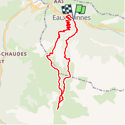
Trail Walking of 17.2 km to be discovered at New Aquitaine, Pyrénées-Atlantiques, Eaux-Bonnes. This trail is proposed by tracegps.

Description

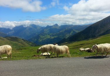
Départ depuis les Thermes des Eaux-Bonnes. Montée par les lacets du bois d'Assousta, puis passage par le col de Gourzy et le Pas de Brèque. Ensuite progression dans les prairies et lapiaz du plateau d'Anouilhas avant d'aboutir au col de Lurdé pour découvrir le Pic du Midi d'Ossau tout proche. Descente par le Cirque de Balour et la Coume de Balour. Randonnée longue et dénivelée importante qui nécessite de bien gérer les organismes.

Elevation profile

Photos

Positioning

Country:
France
Region :
New Aquitaine
Department/Province :
Pyrénées-Atlantiques
Municipality :
Eaux-Bonnes
Location:
Unknown
Start:(UTM)
712738 ; 4760952 (30T) N.

Trails nearby

Trail Walking Béost - Behost - Photo
Walking
swp648

Walking

Easy
(1)
Béost, New Aquitaine, Pyrénées-Atlantiques, France
6 km | 9.9 km-effort
2h 59min
Yes
Trail Walking Eaux-Bonnes - Le Pic Sanctus 2482m depuis Gourette - Photo
Walking
tracegps

Walking

Difficult
(1)
Eaux-Bonnes, New Aquitaine, Pyrénées-Atlantiques, France
11.4 km | 26 km-effort
6h 0min
Yes
Trail Walking Laruns - LARUNS le tour du valentin G3
Walking
GUIDE
marmotte65

Walking

Difficult
Laruns, New Aquitaine, Pyrénées-Atlantiques, France
8.2 km | 12.9 km-effort
2h 56min
Yes
Trail On foot Eaux-Bonnes - La promenade horizontale - Photo
On foot
PRO

On foot

Easy
Eaux-Bonnes, New Aquitaine, Pyrénées-Atlantiques, France
3.5 km | 5.3 km-effort
1h 12min
Yes
Trail On foot Eaux-Bonnes - Les thermes - Photo
On foot
PRO

On foot

Easy
Eaux-Bonnes, New Aquitaine, Pyrénées-Atlantiques, France
3.6 km | 5.9 km-effort
1h 20min
Yes
Trail On foot Laruns - L'eau - Photo
On foot
PRO

On foot

Easy
Laruns, New Aquitaine, Pyrénées-Atlantiques, France
4.8 km | 5.9 km-effort
1h 20min
Yes
Trail On foot Béost - Les crêtes d’Andreyt - Photo
On foot
PRO

On foot

Easy
Béost, New Aquitaine, Pyrénées-Atlantiques, France
9.6 km | 14.7 km-effort
3h 20min
Yes
Trail On foot Eaux-Bonnes - La montagne verte - Photo
On foot
PRO

On foot

Easy
Eaux-Bonnes, New Aquitaine, Pyrénées-Atlantiques, France
10.4 km | 17.8 km-effort
4h 2min
Yes
Trail On foot Louvie-Soubiron - Les carrières - Photo
On foot
PRO

On foot

Easy
Louvie-Soubiron, New Aquitaine, Pyrénées-Atlantiques, France
3.4 km | 7 km-effort
1h 35min
Yes


Close
My subscriptions