Trail On foot Châlonvillars - Chalonvillars - Moulin - Frahier - Le Thiamont - La Foret - Chalonvillars  - Photo

Chalonvillars - Moulin - Frahier - Le Thiamont - La Foret - Chalonvillars

© OpenStreetMap contributors
Length
Length
13.6 km
Max alt
Max alt
434 m
Uphill gradient
Uphill gradient
199 m
Km-Effort
Km-Effort  
16.2 km
Min alt
Min alt
353 m
Downhill gradient
Downhill gradient
201 m
Boucle
Boucle
Yes
Creation date :
2019-09-20 09:47:26.273
Updated on :
2019-09-20 09:53:24.705

(0 Reviews)

On foot
On foot
--
Difficulty : Very easy

Scan this QR Code to open this trail in the SityTrail application

FREE GPS app for hiking

Logo SityTrail SityTrail

IGN / Geographical institutes

Download SityTrail from the App Store Download SityTrail from Google Play

Logo SityTrail SityTrail World

The world is yours!

Download SityTrail from the App Store Download SityTrail from Google Play Download SityTrail on Huawei AppGallery

About

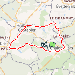
Trail On foot of 13.6 km to be discovered at Bourgogne-Franche-Comté, Haute-Saône, Châlonvillars. This trail is proposed by lebrisgerard.

Description

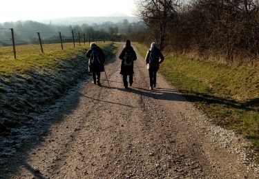
Facile  Sur route, mais peu de voitures. Beau parcours à faire aussi en vélo.

Elevation profile

Positioning

Country:
France
Region :
Bourgogne-Franche-Comté
Department/Province :
Haute-Saône
Municipality :
Châlonvillars
Location:
Unknown
Start:(UTM)
332873 ; 5278692 (32T) N.

Trails nearby

Trail Walking Sermamagny - Veronne PC - Photo
Walking
Papamoju

Walking

Very easy
(2)
Sermamagny, Bourgogne-Franche-Comté, Territoire-de-Belfort, France
8.1 km | 9 km-effort
1h 59min
Yes
Trail Walking Mandrevillars - Echenans et son fort - Photo
Walking
Bart2015

Walking

Very difficult
Mandrevillars, Bourgogne-Franche-Comté, Haute-Saône, France
14.8 km | 19.6 km-effort
4h 27min
Yes
Trail Walking Châlonvillars - Châlonvillars - Fort du Salbert - Evette-Salbert - Photo
Walking
Bart2015

Walking

Difficult
(1)
Châlonvillars, Bourgogne-Franche-Comté, Haute-Saône, France
11 km | 15.8 km-effort
3h 36min
Yes
Trail Mountain bike Châlonvillars - Châlonvillars - Fort Giromagny en passant au milieu des étangs - Photo
Mountain bike
Bart2015

Mountain bike

Very difficult
Châlonvillars, Bourgogne-Franche-Comté, Haute-Saône, France
40 km | 51 km-effort
3h 31min
Yes
Trail Mountain bike Châlonvillars - Châlonvillars - Menhir - Mandrevillars - Fort Essert et du Salbert - Photo
Mountain bike
Bart2015

Mountain bike

Very difficult
Châlonvillars, Bourgogne-Franche-Comté, Haute-Saône, France
31 km | 42 km-effort
2h 53min
Yes
Trail Walking Châlonvillars - Châlonvillars - le mehnir - Mandrevillars - Photo
Walking
Bart2015

Walking

Medium
Châlonvillars, Bourgogne-Franche-Comté, Haute-Saône, France
13.4 km | 17.1 km-effort
2h 39min
Yes
Trail Walking Châlonvillars - Châlonvillars - Mandrevillars - Photo
Walking
Bart2015

Walking

Easy
Châlonvillars, Bourgogne-Franche-Comté, Haute-Saône, France
9.5 km | 11.9 km-effort
1h 33min
Yes
Trail Walking Frahier-et-Chatebier - frahier - Photo
Walking
Evelyne3

Walking

Medium
(1)
Frahier-et-Chatebier, Bourgogne-Franche-Comté, Haute-Saône, France
5.6 km | 6.8 km-effort
1h 44min
Yes
Trail Walking Châlonvillars - Châlonvillars - Mandrevillars par les bois - Photo
Walking
Bart2015

Walking

Easy
Châlonvillars, Bourgogne-Franche-Comté, Haute-Saône, France
10.4 km | 12.9 km-effort
1h 40min
Yes


Close
My subscriptions