Trail Walking Bourbach-le-Haut - SityTrail - Bourbach-le-haut - La fourmi variante - Photo

SityTrail - Bourbach-le-haut - La fourmi variante

Jetz geht's wieder los, noch dem bloede COVID19

© OpenStreetMap contributors
Length
Length
10.3 km
Max alt
Max alt
791 m
Uphill gradient
Uphill gradient
378 m
Km-Effort
Km-Effort  
15.3 km
Min alt
Min alt
536 m
Downhill gradient
Downhill gradient
378 m
Boucle
Boucle
Yes
Creation date :
2020-02-24 10:45:01.416
Updated on :
2020-03-12 07:15:38.946

(0 Reviews)

Walking
Walking
3h11
Difficulty : Difficult

Scan this QR Code to open this trail in the SityTrail application

FREE GPS app for hiking

Logo SityTrail SityTrail

IGN / Geographical institutes

Download SityTrail from the App Store Download SityTrail from Google Play

Logo SityTrail SityTrail World

The world is yours!

Download SityTrail from the App Store Download SityTrail from Google Play Download SityTrail on Huawei AppGallery

About

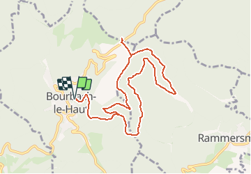
Trail Walking of 10.3 km to be discovered at Grand Est, Haut-Rhin, Bourbach-le-Haut. This trail is proposed by Seppala - Balades du jeudi.

Description

On va à la Fourmi en partant de Bourbach le Haut, balade déjà faite autrefois mais avec un retour inédit.
ACCÈS :
- direction Masevaux puis après Guewenheim avant l'entrée dans Sentheim prendre à droite => Bourbach le Bas => Bourbach le Haut.
PARKING :
- Bourbach le Haut, 300 m après le panneau d'entrée du village, dans un virage à gauche, prendre à droite au panneau "Foyer rural" une petite rue qui y descend
   47.7969001,      7.0308683  ou  
N 47°47'49",       E 7°01'51"
RESTAURATION :      
Restaurant de la Fourmi au col du Hundsruck
Tél: 03 89 38 86 02

Elevation profile

Positioning

Country:
France
Region :
Grand Est
Department/Province :
Haut-Rhin
Municipality :
Bourbach-le-Haut
Location:
Unknown
Start:(UTM)
352539 ; 5295600 (32T) N.

Trails nearby

Trail Walking Masevaux-Niederbruck - Masevaux - Rossberg par le belvédère du Fuchsfelsen - Photo
Walking
Bart2015

Walking

Medium
(1)
Masevaux-Niederbruck, Grand Est, Haut-Rhin, France
19.9 km | 34 km-effort
4h 44min
Yes
Trail Walking Sentheim - Sentheim Rossberg - Photo
Walking
helmut68

Walking

Medium
(1)
Sentheim, Grand Est, Haut-Rhin, France
27 km | 40 km-effort
6h 11min
Yes
Trail Walking Bourbach-le-Haut - 2024-01-12_14h17m14_239006910 - Photo
Walking
GUIDE
mumu.larandonneuse

Walking

Difficult
Bourbach-le-Haut, Grand Est, Haut-Rhin, France
11.4 km | 18.5 km-effort
4h 12min
Yes
Trail Walking Lauw - 2022-07-14 Marche Lauw Refuge CAF Baerenkopf - Photo
Walking
GUIDE
holtzv

Walking

Very difficult
Lauw, Grand Est, Haut-Rhin, France
18.4 km | 31 km-effort
5h 35min
No
Trail On foot Sentheim - Sentier géologique du Wolfloch - Photo
On foot
PRO

On foot

Easy
Sentheim, Grand Est, Haut-Rhin, France
3.8 km | 4.8 km-effort
1h 5min
No
Trail On foot Sentheim - Sentheim - Bergwald - Eichwald - Guevenheim - Sentheim - Photo
On foot
patrickbeyrath

On foot

Easy
(1)
Sentheim, Grand Est, Haut-Rhin, France
13.4 km | 16.6 km-effort
Unknown
Yes
Trail On foot Bitschwiller-lès-Thann - Bitschwiller les Thann - Rehbrunnel - Abri du Becherkopf - Roche Albert - Photo
On foot
patrickbeyrath

On foot

Medium
(1)
Bitschwiller-lès-Thann, Grand Est, Haut-Rhin, France
10.3 km | 16.4 km-effort
Unknown
Yes
Trail Walking Bitschwiller-lès-Thann - 68 Col du Hundsrück  - FA Gsang - retour ThannerHubel - Photo
Walking

Walking

Medium
(1)
Bitschwiller-lès-Thann, Grand Est, Haut-Rhin, France
11.2 km | 18.4 km-effort
3h 48min
Yes
Trail Walking Masevaux-Niederbruck - Rando CLAS du 25/04/2024 - Photo
Walking
boubou68

Walking

Very difficult
Masevaux-Niederbruck, Grand Est, Haut-Rhin, France
17 km | 28 km-effort
4h 24min
Yes


Close
My subscriptions