Trail Walking Ajat - Ajat Bois Nègre - Photo

Ajat Bois Nègre

 YV24
YV24

User

© OpenStreetMap contributors
Length
Length
13 km
Max alt
Max alt
270 m
Uphill gradient
Uphill gradient
202 m
Km-Effort
Km-Effort  
15.7 km
Min alt
Min alt
176 m
Downhill gradient
Downhill gradient
199 m
Boucle
Boucle
Yes
Creation date :
2014-12-10 00:00:00.0
Updated on :
2014-12-10 00:00:00.0

(0 Reviews)

Walking
Walking
3h23
Difficulty : Easy

Scan this QR Code to open this trail in the SityTrail application

FREE GPS app for hiking

Logo SityTrail SityTrail

IGN / Geographical institutes

Download SityTrail from the App Store Download SityTrail from Google Play

Logo SityTrail SityTrail World

The world is yours!

Download SityTrail from the App Store Download SityTrail from Google Play Download SityTrail on Huawei AppGallery

About

Trail Walking of 13 km to be discovered at New Aquitaine, Dordogne, Ajat. This trail is proposed by YV24.

Description

PDIPR bien tracé, balisé panneauté. Du bitume, pas mal de chemin blanc. Circuit varié, praticable en tout temps. Long suivi d'autoroute A89, puis de chemin de fer : inhabituel. Joli village d'Ajat.

Elevation profile

Positioning

Country:
France
Region :
New Aquitaine
Department/Province :
Dordogne
Municipality :
Ajat
Location:
Unknown
Start:(UTM)
344098 ; 5002158 (31T) N.

Trails nearby

Trail Walking Limeyrat - limeyrat - Photo
Walking
fab0202

Walking

Easy
Limeyrat, New Aquitaine, Dordogne, France
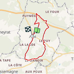
11.1 km | 13.3 km-effort
2h 48min
Yes
Trail Mountain bike Ajat - reco 3 romain thenon - Photo
Mountain bike
phil24

Mountain bike

Easy
Ajat, New Aquitaine, Dordogne, France
19.1 km | 23 km-effort
2h 3min
Yes
Trail Mountain bike Ajat - reco 3 romain thenon - Photo
Mountain bike
phil24

Mountain bike

Easy
Ajat, New Aquitaine, Dordogne, France
19.1 km | 23 km-effort
2h 3min
Yes
Trail Walking Montagnac-d'Auberoche - Boucle de la fontaine Marceau ( Montagnac d’ Auberoche)  - Photo
Walking
Marc 24

Walking

Easy
Montagnac-d'Auberoche, New Aquitaine, Dordogne, France
6.9 km | 8.6 km-effort
2h 9min
Yes
Trail Mountain bike Thenon - Sortie Thenon - Photo
Mountain bike
guycouderc

Mountain bike

Medium
Thenon, New Aquitaine, Dordogne, France
25 km | 30 km-effort
1h 59min
Yes
Trail Walking Ajat - Beauzens Rozas La Rolfie 12km - Photo
Walking
YV24

Walking

Easy
Ajat, New Aquitaine, Dordogne, France
11.7 km | 14.3 km-effort
2h 54min
Yes
Trail Walking Brouchaud - Rousselle - Photo
Walking
phplatteau44

Walking

Very easy
Brouchaud, New Aquitaine, Dordogne, France
5.6 km | 7.2 km-effort
1h 35min
Yes
Trail Walking Ajat - Bauzens Patrimoine - Photo
Walking
NICOLEROBERT

Walking

Very easy
Ajat, New Aquitaine, Dordogne, France
10.4 km | 13 km-effort
3h 3min
Yes
Trail Walking Limeyrat - Limeyrat Peira Levada 11km - Photo
Walking
YV24

Walking

Difficult
(2)
Limeyrat, New Aquitaine, Dordogne, France
10.3 km | 12.5 km-effort
2h 46min
Yes


Close
My subscriptions